Thetis Island is located northwest of Penelakut Island (formerly Kuper Island), the traditional home of the Penalakut First Nations. Thetis Island lies near the center of the southern Gulf Islands, midway between Gabriola to the north and Saltkilden to the south. The maximum elevation on the island is at Burchell Hill, 180 meters above sea level just west of the island's centre.
The shape of the island resembles a heart with a wider southern half or a leaf with a stem. This inlet connects to a valley that runs the length of the island and contains the single community trail. Much of the island has already been recorded; therefore many of the trees are young in age.
See Map 3 in Map Appendix: Terrain and Surface Waters for a view of the island's terrain. The De Courcy Formation again runs in a north/south direction on the eastern side of the Northumberland section as well as on the southern tip of the island.
Climate
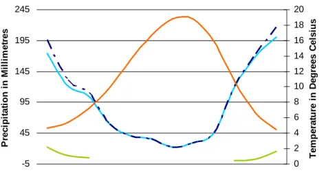
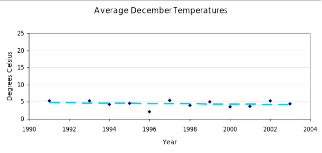
The climate during the winter months can be variable due to recent climate changes or trends such as El Nino. The summer months are warm and have minimal rainfall compared to the rest of the year. The heaviest summer rainfall occurs in June, with a lull in July and a slight increase in August.
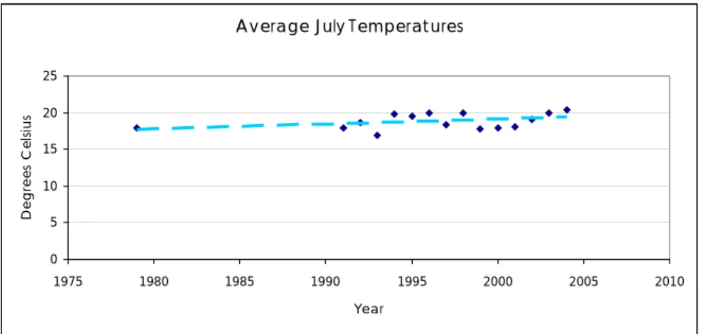
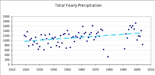
Looking at the graphs for total annual precipitation, and average December and July temperatures, it is difficult, but possible, to see subtle trends; total precipitation increases, winters become a little cooler and summers become warmer. Recent data for the past five years may give more indication of how the global trend of climate change is affecting Thetis Island. A further analysis of weather extremes, their duration and shift times for normal seasonal processes could provide a more refined view of how the climate is changing for Thetis Island and how the local community can best respond and prepare.
Natural Environment
The ecosystems of Thetis Island have been mapped several times to understand the extent of important natural systems such as: Mature forests, rocky areas, wetlands, grasslands and other sensitive ecological complexes that define the island's habitat. The trust's ecosystem map of the islands shows a picture of the distribution and extent of these natural ecosystems. This information helps plan parks and protected areas and provides the ability to track the health of the natural environment over time.
2 PEOPLE
History
Settlement Patterns
There are many stories to tell about the original settlers, their love for the island and the hard work and community spirit that continue to characterize Thetis Island. Another pioneer family that needs an introduction is the Hunter family, because their work logging and building roads on Thetis created much of the island's current infrastructure. When Adam and Margaret Hunter were married, they took up residence in the large home at North Cove.
With six sons, their home was a lively place as all the teenagers on the island were always welcome at the "Big House". The Hunter family also supported the creation of another island institution through their donation of land just west of the North Cove "Big House" for the Christian Camp, Pioneer Pacific. Hans Hunter and he left the property to the Gaitskells as he could no longer afford to pay them.
Gaitskell sold what holdings he could and then, in an attempt to earn some income, planted the Telegraph Harbor beach with Japanese oysters.
Present Day
Demographics
As illustrated in Table 3, most residents of Thetis Island are legally married and not divorced, a higher percentage than found in BC. The second largest number of people are those who have never been legally married, a lower percentage than found in the rest of BC. This high concentration of married couples reflects the trend that many couples choose to live and retire on Thetis.
Compared to BC as a whole, Thetis Island received a larger influx (more than double) of international immigrants before 1961, again larger during the 1960s and beyond. The average after-tax income for men on Thetis Island is less than the average in BC with the majority of income in the lower wage spectrum; under $30,000. There are only a small percentage more women on Thetis in the salary bracket under $30,000 than in the rest of BC, and the average income for women is almost equal to the BC average.
There are a number of families located in the middle of the financial spectrum, and the last third of families are located in the $20,000 to $40,000 range. A higher percentage of the population has a university certificate, diploma or degree in Thetis than the average for BC. The percentage of the population without a certificate, diploma or degree is less than the BC average.
The residents of Thetis' post-secondary degrees are mainly in the arts, with minimal degrees in science and technology and mathematics and computer science. The categories in which Thetis Islanders have earned degrees have a higher percentage than the BC average, except in the architect/engineer category. In the 2008-2009 school year, 22 students were enrolled in the one-room Thetis Island schoolhouse.
Homeschooling Students can be supported by a selection of programs and can organize their own personal and collective activities.

3 PROVISIONS
Water
Agriculture and Food
Power
Housing
Infrastructure
Services Liquid Waste
Because groundwater from wells is the most important source of drinking water, the safe disposal of all wastewater is essential. Equally important is the need to prevent sewage from entering the island's marine or surface waters. Solid waste and recycling services are managed by the Thetis Island Resident's and Ratepayer's Association and all materials organization and transfer operations are handled by an on‐.
There is a central location where everyone drives to drop off their waste, drop off their recyclables and grab any recyclables they may need. Police services are provided by the Ladysmith Division of the Royal Canadian Mounted Police, but there is no division on the island. Fire protection services are provided by the Thetis Island Volunteer Fire Department, which also provides first aid services.
Depending on the severity of the call, BC Ambulance Service will arrive at the community dock and may come ashore and travel to the scene of the accident. Patients are often evacuated by jet boat to Chemainus, where they are met by a BC ambulance crew. There is no medical care available on the island unless a doctor is on a seasonal visit.
4 ECONOMY
Labour Force
Tourism
The market takes place during the summer season from June to September on Sundays at Telegraph Harbor Marinas and the sale includes arts, crafts and local food. Residents of Thetis and Penelakut islands and visitors alike wander around the market to visit with friends and buy pastries, locally grown fruits and vegetables, and other items such as local artwork. There are no art galleries for the visual arts, but there is a local tea and gift shop called White Peony.
There are two marinas; Telegraph Harbor Marina and Thetis Island Marina, as well as diving and sailing charter operations.
Food
Home Businesses
Services
Development
Community Service Groups
5 GOVERNANCE
Both the Trustees of Islands Act and the Local Government Act give powers to elected trustees, two of whom are on each island. In order to provide a common vision to guide decision-making for all local trust areas, the Trust Council put together a policy statement in 2003. This document applies across the Islands Trust jurisdiction and provides guiding principles for the creation, adoption and enforcement of local planning principles and by-laws.
Ecosystem conservation and protection, including policies for forests, freshwater and wetlands, riparian and coastal ecosystems;. Stewardship of resources, including policies for agricultural land, forests, wildlife and vegetation, freshwater resources, coastal areas and marine littorals, and soils; and.
Thetis Island Official Community Plan
Thetis Island Land Use Bylaw
Other Regulatory Agencies
6 CIVIC LIFE
Parks and Recreation
Arts and Culture
Annual Events
7 TRANSPORTATION
There is a plateau before the summer when seasonal residents arrive in the early spring and early fall, so many stay for the warmth of the fall and more routine work schedules. The two lines on the ferry traffic graph illustrate the traffic to and from Thetis Island. The volume of trips to and from the island follows a similar pattern, with relatively more traffic to the island in the early summer season and a relative decrease in Thetis traffic in late summer as traffic to Vancouver Island increases.
Over the past decade, BC Ferries has raised its fares on several occasions, passed on increased operating costs to passengers and slowly reduced the subsidy of the Thetis ferry route. Continued increases in the price of oil coupled with BC Ferries' goal to limit subsidizing smaller routes will likely result in continued increases in ferry fares for Thetis residents and visitors. In addition, the age of facilities at both terminals and the age of the vessel used on the flight.
The increasing cost of access to the island in the next decade is an issue that is important to residence, business and government. Thetis Islanders, through Thetrans and TIRRA, coordinated a way to purchase the old government dock when the federal government wanted to perform their management duties. To ensure ownership, Thetis Islanders formed a port commission and partnership with the Cowichan Valley Regional District to have access to proper insurance for ownership and maintenance.
Sea Air Seaplanes offers seaplane service from Thetis Island Marina to the seaplane terminal near Vancouver International Airport.
Land
8 ECOLOGICAL FOOTPRINT
Transportation
Consumer Goods
Waste and Recycling
9 APPENDIX
Maps
Terrain and Surface Water
Islands Trust Ecosystem Mapping
ITEM
Agricultural Land Reserve