UNIVERSITA’ DEGLI STUDI DI NAPOLI “FEDERICO II”
Di.S.T.A.R. - Department of Earth Sciences, Environment and Resources
Doctorate School in Analysis of Environmental Systems - XXVI Cycle
UNIVERSITAT POLITÈCNICA DE CATALUNYA
R.S.Lab. - Remote Sensing Laboratory - Signal Theory and Communications Department
Doctoral Program in Signal Theory and Communications
Application of DInSAR techniques to the monitoring
of ground deformations
Ph.D. Thesis
Serena Tessitore
Advisors
Coordinators of the Doctorate Schools
Prof. Domenico Calcaterra Prof. Maurizio Fedi
Prof. Jordi J. Mallorqui Prof. Carlos López-Martínez
Co-Advisor
"Tu patria son tus amigos"
Contents
i
Contents
Abstract
...iv
Acknowledgements
...
v
CHAPTER I. Introduction
...
1
1.1. Structure of the thesis
...
3
1.2. Objectives
...
4
1.2.1. Thesis history
...
7
1.3. Materials and methods
...
9
CHAPTER II. Subsidence
...
13
2.1. Definition and classification
...
13
2.2. Importance of the phenomena: social hazard and historical cases
...
13
2.3. DInSAR monitoring of subsidence phenomena
...
15
2.3.1. Hydrological models
...
15
2.3.2. Geotechnical models
...
17
2.3.3. Structural monitoring
...
17
2.3.4. DInSAR monitoring of subsidence phenomena in Italy
...
19
CHAPTER III. Subsidence monitoring
...
28
3.1. Subsidence monitoring techniques
...
28
3.1.1. In situ techniques: Instrumental methods
...
29
3.1.1.1. Extensometers
...
29
3.1.1.1.1. Rod extensometers
...
29
3.1.1.1.2. Differential extensometers
...
30
3.1.1.2. Inclinometers
...
31
3.1.1.3. Micrometers
...
33
3.1.1.4. Instrumental methods to the cracks monitoring
...
34
3.1.1.4. Crackmeter
...
36
3.1.2. Remote sensing detection
...
37
3.1.2.1. Topographic conventional methods
...
38
3.1.2.2. Geodesic methods
...
39
3.1.2.3. Photogrammetric methods
...
41
3.1.2.4. Radar remote sensing techniques
...
41
3.1.3.4.1. GB-SAR
...
43
3.1.3.4.2. Airborne Radar
...
44
CHAPTER IV. Radar remote sensing techniques
...
46
4.1. Introduction: Radar acquisition geometry and images characteristics
...
46
4.2. Synthetic Aperture Radar
...
49
4.3. SAR limitations: parameters affecting radar backscatter and distortions
...
53
4.3.1. Parameters affecting radar backscatter
...
53
ii
4.4. SAR interferometry
...
60
4.5. Differential Interferometry
...
66
4.5.1. Error sources
...
68
4.6. Advanced DInSAR Interferometry techniques
...
70
4.6.1. A-DInSAR application
...
72
4.7. Coherent Pixels Technique
...
73
CHAPTER V. Subsidence modelling
...
81
5.1. Geotechnical overview
...
81
5.1.2. Over-consolidation stress
...
84
5.1.3. Oedometer test
...
85
5.1.4. The consolidation process
...
89
5.1.4.1. Terzaghi’s equations
...
92
5.1.4.2. Biot’s elastic theory
...
96
5.1.4.3. Subsidence due to water exploitation
...
98
5.1.4.3.1 Cause-effect hydrogeological mechanism
...
98
5.1.4.3.2. Subsidence models of soil response to the water exploitation
...
101
CHAPTER VI. Case studies
...
103
6.1. Murcia case study: introduction and phenomenon description
...
103
6.1.1. Previous studies
...
103
6.1.2. Study area settings
...
106
6.1.2.1. Geological settings
...
106
6.1.2.2. Hydrogeological and geotechnical settings
...
108
6.2. Monitoring data
...
110
6.2.1. In situ monitoring
...
110
6.2.1.1. Piezometers data analysis
...
110
6.2.1.2. Extensometers
...
114
6.2.1.3. Comparisons between extensometric data and water level variations
...
116
6.2.2. A-DInSAR monitoring
...
119
6.2.2.1. CPT processing
...
119
6.2.2.1.1. Sensibility analysis of the parameters influencing the displacement time series
...
123
6.2.2.1.2. CPT processing results
...
128
6.2.2.2. SPN data
...
131
6.2.3. Comparisons
...
132
6.2.3.1. Comparisons between CPT and SPN radar data
...
132
6.2.3.1.1. Spatial analysis
...
132
6.2.3.1.2. Time series analysis
...
133
6.2.3.2. Comparisons between radar and in situ monitoring data
...
137
6.2.3.2.1. Comparisons with piezometric data
...
137
6.2.3.2.2. Comparisons with extensometric data
...
141
6.2.3.2.3. Spatial evolution
...
149
6.3. Subsidence modelling
...
151
6.3.1. Model description
...
151
6.3.1.1. Input data
...
153
6.3.1.1.1. stratigraphic columns
...
153
Contents
iii
6.3.1.1.3. Geotechnical and hydrogeological properties
...
155
6.3.1.1.3.1. Local geotechnical characterization: oedometers
...
156
6.3.2. Sensibility analysis of the model
...
159
6.3.3. Model results and error computation
...
165
6.3.3.1. Deep models
...
167
6.3.3.1.1. Spatial analysis of the deep model results
...
174
6.3.3.1.2. Deep model correction for the North-Western part of Murcia City
...
176
6.3.3.2. Shallow models
...
178
6.3.3.3. Discussion
...
184
6.4. Geostatistical analysis: Bidimensional model
...
187
6.4.1. Geostatistical techniques: overview
...
187
6.4.1.1. Kriging with External Drift (KED)
...
192
6.4.1.2. Co-Kriging (CK)
...
194
6.4.1.3. Ordinary Kriging of Radar Errors (OKRE)
...
194
6.4.2. Deep model results interpolation
...
195
6.5. CPT processing improving using the model computed deformation maps
...
206
6.6. Telese Terme case study: introduction
...
209
6.6.1. Study area setting
...
210
6.6.1.1.Geological and hydrogeological settings
...
210
6.6.2. A-DInSAR monitoring
...
213
6.6.2.1. Results analysis
...
215
6.6.3. Structural analysis
...
217
6.6.3.1. Structural model
...
219
6.6.4. Geophysical surveys
...
224
6.6.5. Discussion
...
228
CHAPTER VII. Conclusions
...
230
7.1. Future research development
...
234
References
...
236
iv
Abstract
Subsidence is a natural hazard which affects wide areas in the world causing important economic losses
annually. This phenomenon has occurred in the metropolitan areas of Murcia City (Spain) and of Telese
Terme (Italy), causing relevant economic damage to structures and infrastructures. In Murcia city,
subsidence is the result of groundwater overexploitation; due to the intensity of the phenomenon,
institutions requested detailed studies since the ’90, to understand its cause-effect mechanisms. For this
reason a monitoring network of extensometers and piezometers has been installed and implemented
during the years. Telese Terme has been affected by subsidence due to its geological and hydrogeological
settings. Here, in fact, the underground water circulation provokes piping phenomena in the surficial
fine-grained soils and, because of chemical characteristics and physical properties of the water, may also
activate processes of accelerated travertine’s corrosion. In this case, a monitoring network is not available
and the only evidences of the phenomenon occurrence are the structural damage to buildings. These two
study areas have been chosen to test the applicability of the innovative Advanced DInSAR techniques in the
natural risk mitigation related to subsidence phenomena. In particular, these techniques can complete a
monitoring network where available (as in the case of Murcia city) and partially replace it in case of its
absence (as in the case of Telese Terme). In the first case, such techniques allowed to implement an
integrated monitoring system based upon satellite DInSAR monitoring, in situ monitoring and geotechnical
data. In particular, the correlation of the temporal evolution of ground surface displacement measures
(radar and in situ) and the piezometric groundwater level variation have been analyzed to determine
mechanisms and critical states of failure; this has permitted to implement a finite element model (FEM) of
the phenomenon. The proposed numerical model will allow the prediction of possible future deformations
and the consequences of any piezometric level variation in the study area. This is regarded as necessary to
better plan the subsequent water resources exploitation and the land use management. In the Telese
Terme case study, radar measured displacements allowed to understand the spatial extension of the
phenomenon, its magnitude as same as its historical development. In fact, a remote sensing monitoring
system allows the knowledge of unmonitored phenomena also in the past. This has permitted the
individuation of the causes which provoked damage for some “test buildings”. For one of them, a structural
model has been implemented; in this case, radar data have been used to verify whether its structural
response to the displacements detected by SAR corresponds to the overpassing of the limit states. In
conclusion, it has been argued that the proposed approaches could be applied to other scenarios affected
by similar phenomena.
Keywords
Acknowledgements
v
Acknowledgements
Many people have given their support to my PhD research and I am deeply grateful to all of them.
I have had the luck to collaborate with many research groups which have shared with me their high-professional technical competence, and above all they have always made me feel like at home, with their warm welcome and kindness.
I truly feel that all the thesis acknowledgements are not directed to collaborators, but to friends. After only one year spent in Spain, I feel to belong to two countries and the dedication "Tu patria son tus amigos" (your country are your friends) has been the perfect way to dedicate this thesis to all of them.
First of all, I want to thank my supervisors which have provided me this opportunity of great professional and personal growth.
Prof. Domenico Calcaterra (University of Naples) for his guidance and precious suggestions. I am very grateful to him for being my tutor and for having put his trust in me.
Prof. Jordi J. Mallorqui (UPC - Barcelona) for welcoming me and for his constant support.
Dr. Ing. Massimo Ramondini (University of Naples), for his endless helpfulness. He has been my reference point in every moment and at every hour both of night and day, my omnipresent technical and moral support!
Dr. Ing. Gerardo Herrera (IGME – Madrid) because, without him, this research would have not been possible. I have not enough words to adequately thank him. He has been first of all a friend and after a tutor, a guide and a constant support.
I would also like to show my gratitude to Prof. Filippo Barattolo and Prof. Maurizio Fedi (University of Naples), coordinators of the PhD School, which allowed me to enrich my studies with a challenging international experience.
Then I would like to thank all the people which have collaborate to this work; in particular:
vi Dr. Carolina Guardiola Albert and Dr. Margarita Sanabria Pabón (IGME – Madrid) for their inestimable support in geostatistical applications and their kindness and willingness;
Dr. Giuseppe Centolanza, Dr. Dani Monells, Dr. Ruben Iglesias (UPC – Barcelona), for the great help in the SAR processing learning and to be always patiently available to solve all the occurred issues;
Dr. Diego Di Martire (University of Naples) for his help during my PhD, especially for his explications concerning the SAR processing in an “Italian version”!
Dr. Alessandro Novellino (University of Naples) for his geological revisions and help, always provided with a smile and to Dr. Ahmed Ali for his help in the bibliographic research;
Mirko Iannarone for his support in the structural modelling;
Dr. Vincenzo Fuschini for the know-how regarding the geological and hydrogeological settings of Telese Terme and for the data feedback;
Dr. Joaquín Mulas (IGME - Madrid) for his kindness, precious suggestions and for 20 years of shared knowledge about Murcia case study;
Dr. Gabriella Castiello for the geophysical support;
Dr. Gabriella Tessitore (Bochum University), my sister, friend and colleague for her help in the English revisions, for our interesting mathematical debates and simply for being her!
Finally, I would like to acknowledge the referees of the thesis, Prof. Roberto Tomás and Prof. Kurosch Thuro for the important contributions to the work improvement.
Other kind acknowledgements have to be given to all those people who have made this experience unforgettable. A limitless thanks to all the IGME’s and the UPC’s teams (Diana, Robert, Marta, Esther, Esther, Virginia, Josè, Imma, Rosa, Raul, Dani, Ruben, Giuseppe, Alberto) and to the “IGME’s little Italy” for welcoming me with open arms and for being my Spanish family.
Acknowledgements
vii A big thanks to Virginia Zamparelli and Silvia De Simone for all the wonderful moments spent together in the beautiful Barcelona and for all the help they have provided me.
Another kind thanks to Rosa Maria Mateos, Immaculada Garcìa, Curro Roldan and Josè Miguel Azañón to the best tour (geological, cultural and gastronomical) of Granada and Mallorca ever!
A big thanks to Francesca Dalènz for her help in the thesis’ summary Spanish translations and to all the group of Italian friends which enjoy my stay in Madrid (Silvia, Roberta, Stefano, Ivan, Elisa, thanks for all).
The greatest thanks is for my family, my endless and unconditional support ever: to my parents and all the uncles and friends which have never leave me alone and to my soul, Danilo, for having always been near to me despite the distance and hold up my choices, being my main fan, my happiness, my peace.
Thanks, gracias, grazie, gràcies.
The SAR images used in this work for Murcia city were provided by the European Space Agency (ESA) in the framework of the EO CAT11 project 2494. The TerraSAR-X images were provided by DLR in the framework of the scientific project GEO0389: "High resolution DInSAR monitoring of subsidence induced by aquifer exploitation in the Vegas Baja and Media of the Segura river, SE, Spain”. Furthermore, the ESA Terrafirma project has funded all the SAR data processing with the SPN technique.
For the Telese Terme area, the ENVISAT images for the period 2002-2010 and the SAR data processed with PSInSAR technique were provided thanks to a specific agreement between the Department of Hydraulic, Geothecnical and Environmental Engineering of the University of Naples and the Italian Ministry of Environment (MATTM)
The Spanish Geological and Mining Institute (IGME), EMUASA, the Hydrographic Confederation of Segura (CHS), the company “Aguas de Murcia” and the Regional government of Murcia were so kind to provide piezometric and hydrological data. The extensometric data were provided by the Regional government of Murcia and by IGME. The Cartographical Service of Murcia (CARTOMUR) has provided DEM data and aerial photographs used in this work.
CHAPTER I
Chapter I. Introduction
1
Chapter I. Introduction
Subsidence is a gradual settling or sudden sinking of the Earth’s surface owing to subsurface movements of Earth materials. It represents a natural hazard, causing relevant economic damage and social alarm. It can affect wide areas over variable time periods, with deformations which can vary from a few millimetres to several meters. It may be due to several causes, both natural and anthropic, like compaction of soil materials, fluid withdrawal (oil, water, gas), deep material dissolution, excavation of tunnels or mining galleries, deep erosion (piping), lateral soil creep, or tectonic activity.
Therefore, subsidence risk assessment and prevention is a key-point for a correct territory management. For this reason, it is necessary to determine mechanisms and critical states of failure, and to evaluate, knowing the causes, possible corrective measures and their effectiveness (Tomás et al., 2005a). Thus, an effective monitoring system represents the starting point for the decision-making and the problem solving processes (Thuro and Schubert, 2009).
The development of subsidence monitoring techniques has allowed passing from the traditional topographic surveys, to the instrumental methods (i.e. extensometer), yielding to punctual measures of the ground deformations.
An effective monitoring system should be well distributed in the subsiding area and provide measures in the whole period of the phenomenon occurrence to reach a correct analysis of its evolution. This implies the necessity of a great number of instrumental installations, often resulting in high costs. Furthermore, the displacement measurements have to be matched with other physical factors, related to the examined phenomenon causes (i.e. piezometric level variation), also leading to additional costs.
The technological progress has provided new techniques for deformation measurements. In particular,
Remote Sensing techniques have demonstrated to be powerful investigation tools for their high spatial and multi-temporal coverage, fast data acquisition, and overall low costs. Thanks to the recent development of the sensor technology, it has been employed as a monitoring system for various instability phenomena, such as volcanic eruptions, earthquakes, landslides, subsidence, sinkholes, and it has been proficiently used for the related risk assessment.
In fact, among the various radar sensors, the modern Synthetic Aperture Radar (SAR) devices are able to irradiate the observed areas with microwaves, resulting in the transparency of the clouds. Therefore, they are able to operate 24-hour a day, and in any cloudiness condition. In particular, through the innovative
2 along the sensor Line of Sight (LOS), by calculating the differences of images referred to the same area, but detected in different times. The use of these techniques yields to a monitoring of wide areas (for the whole images acquisition period) characterized by a millimeter accuracy (function of the radiation wavelength) and it results to be particularly effective if these areas show deformations with a predominant vertical component, as in the case of subsidence andsinkholes.
A remote sensing monitoring system allows the integration of conventional techniques, if available, and the knowledge of unmonitored phenomena also in the past. The so obtained information about the historical development of a given phenomenon, permit to understand its cause-effect mechanism or to correlate the measured deformations with other monitored variables, if directly correlated with the phenomenon occurrence.
The details of the historical time evolution achieved through these techniques are function of the time elapsed between observations of the same point (revisit time: 4-8 days in the case of the recent COSMO Sky-Med and Terrasar-X satellite constellations vs. 35 days for ERS and ENVISAT). As to obtain comparable results, a long and continuous monitoring through traditional field surveys is required, also if often impossible to perform over wide areas, and highly costly and time-consuming.
The processing results, however, could not be conveniently used without their validation, necessary also to discretize the millimeter displacements detected by the SAR. In fact, displacements measured by radar could represent, for example, a structural response to the soil settlement and not directly its deformation.
Therefore, it is necessary to define the so-called “ground truth”, through the complete knowledge of the phenomenon characteristics. To this aim, the reconstruction of the geological and geotechnical model of the study area, based on the well-established field surveys and in situ instrumental monitoring is requested.
For the above reasons, implementing an integrated monitoring system of in situ and radar data could be employed to obtain reliable information of a phenomenon, in points not covered by the monitoring network or in achieving measures of variables related with the subsidence causes. In this case, displacement measurements could also give an estimation of an unmonitored variable (or unmonitored only in a part of the observation period), related with the observed phenomenon (i.e. water table levels), through a back-analysis procedure.
Chapter I. Introduction
3
1.1. Structure of the thesis
The thesis develops in seven chapters.
1. The first chapter includes the thesis objectives, material and methods.
2. In the second chapter the subsidence definition, several historical cases, and the related social
problems are introduced.
3. The third chapter illustrates the different subsidence monitoring systems.
4. In the fourth chapter, the DInSAR techniques are described.
5. The fifth chapter tackles the theme of the geotechnical and hydrogeological explication of the
subsidence phenomenon.
6. The sixth chapter shows the application of DInSAR techniques to the study areas (Murcia city, SE
Spain; Telese Terme, SW Italy). In particular, the processing results have been used to the
implementation of an integrated monitoring system based upon satellite DInSAR, conventional field
techniques and geotechnical data.
7. The seventh and last chapter reports the work’s conclusions and provides a critical analysis of the
4
1.2. Objectives
The present thesis is devoted to the implementation of an integrated monitoring system based upon satellite DInSAR, conventional field techniques and geotechnical data. In particular, the aim is to test the applicability of A-DInSAR results to the natural risk mitigation related to the subsidence phenomenon.
For this reason, two test sites have been chosen, both located within alluvial plains and affected by subsidence phenomena (Fig. 1.1):
∙
Murcia city (SE Spain);∙
Telese Terme (Benevento Province) in Campania Region (SW Italy).In the first case, DInSAR results have been used to model the subsidence phenomenon occurred in the metropolitan area through their integration with in situ monitoring and geotechnical data.
In the second case, DInSAR data have been employed to analyse the subsidence effects on structures. In particular, in an area where a monitoring network does not exist, they have been useful to verify whether the structural response of some buildings to the displacements detected by SAR overpassed the limit states.
Therefore, these two areas have allowed to test different approaches in using DInSAR results. Moreover, they can complete a monitoring network where available (as in the case of Murcia city) and partially replace it in case of its absence (as in the case of Telese Terme).
These two test sites have been chosen considering as discriminating factors the typology and the
Chapter I. Introduction
5 magnitude of the instability phenomena. In fact, in Telese Terme and in the metropolitan area of Murcia City, subsidence has provoked damage to structures and infrastructures, which, for the second case of study, have been estimated to be more than 50 million euros in the ‘90s.
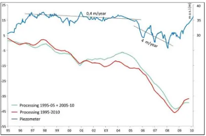
Murcia city represented the first case in Spain of subsidence due to aquifer system consolidation, in turn induced by ground water overexploitation (Tomas et al., 2011). Subsidence affects the first 5-30 m of fine-grained soils overlying a gravel layer where the pumping takes place. It has arisen in the flood plain of the Segura River, also known as the Vega Media (where Murcia city is located), since 1992. Consequently, a monitoring network of extensometers and piezometers has been installed and implemented during the years, in order to understand the cause-effect mechanisms of this phenomenon and to better plan the subsequent water resources exploitation and the land use. In particular, the temporal evolution of the subsidence in Murcia city has been monitored by an extensometer network since 2001 (Mulas et al., 2001, 2004, 2005; Peral et al., 2004), while since 1974 groundwater table variations (Aragón et al., 2004) have been recorded through a spatially dense piezometric network. The availability of the up-to-date extensometer measurements until November 2012, has allowed a complete analysis of the soil behaviour, including not only the subsidence phases occurred in the study area, but also the soil response to the last water level up-lift phase.
Moreover, the great amount of available field surveys and boreholes have allowed the implementation of a geotechnical model of the surficial aquifer. To this aim, the geotechnical and hydrogeological characterization performed by Mulas et al. (2003) and updated by Mulas et al. (2010) for the materials of the Vega Media of the Segura river (VMSR) has been adopted.
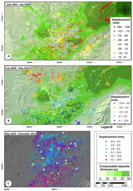
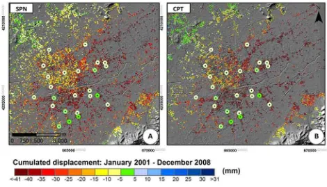
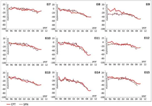
Subsidence has been analysed through the application of different Advanced DInSAR techniques. In this regard, the processing of the available SAR images has been performed through the Coherent Pixels Technique (CPT, Mora et al. 2003) and the results have been compared with other DInSAR data carried out with other techniques.
The displacement time series estimated through these techniques represent the whole deformation of the stratigraphic column and, for this reason, have been compared with the results of the model implemented up to the base of the surficial gravel layer (where the pumping takes place). These comparisons have allowed the individuation of local anomalies of the stiffness values, and have permitted a best model calibration.
6 detailed stratigraphic columns and a new model has been proposed.
Therefore, the integration of in situ measurements and DInSAR displacement estimates has permitted the calibration and the validation of a numerical model. Through the achieved validated model, it will be possible to predict future deformations of a given monitored area, finding the consequences of any variation of the imposed boundary conditions.
Today, several piezometers, installed in the study area, continue to supply data every 8 hours; considering that the extensometer measurements are taken about three times a year, the up-to-dated model results (achieved considering the real-time water level variation) could be very useful to the natural risk mitigation. At the same time, a future continue monitoring of the study area could be performed through the update of the achieved processing of the SAR images acquired by the high-resolution Terrasar-X radar satellite constellation. It is characterized by a revisit time of 11 days that could facilitate the risk management.
Using the model results, it has also been possible to obtain 2D maps of deformations, (performed with different geostatistical techniques) in order to well analyse the spatial evolution of the phenomenon. The 2D maps, then, have been used in the A-DInSAR processing to correct the differential linear part of the interferometric phase (related to the soil deformation) and to better estimate its non-linear part.
In the Telese Terme case, the purpose of the project regards the utilization of multi-pass DInSAR algorithms (Sanabria et al. 2013) to control the evolution of the structural damage in buildings located in a subsiding urbanized area. Then, a structural model of a building affected by severe damage has been performed. The differential settlements measured by SAR have been used to verify the structure. The model results have been then compared with the forensic analysis achieved in situ.
This could allow to mitigate the risk in an area where a monitoring system does not exist, by using this remote sensing technique as a complementary tool for the forensic analysis of building structures.
Chapter I. Introduction
7
1.2.1. Thesis history
The thesis project began in April 2011 and the original aim was to use A-DInSAR techniques to analyse phenomena characterized by a predominant vertical component (subsidence and sinkholes). The first choice of the study areas, supported by the bibliographic research, was obtained taking into account as discriminating factors: amount and quality of available data; typology and magnitude of the instability phenomena. In particular, a specific attention was given to these areas where both subsidence and sinkholes phenomena could be analysed.
Starting from a first list of Italian areas, including San Vittorino plain (Rieti province), Contursi (Salerno province), Telese Terme (Benevento province), Bottegone (Grosseto province), Palermo, the choice was subjected to substantial changes during the years. This was due to the unavailability of financial aid to the research which limited the acquisition of the in situ ancillary data necessary to the DInSAR results validation for most of the selected areas. Therefore, the exposed research project has been carried on with the help of external collaborations provided by some colleagues.
For this reason, two areas were chosen, located within alluvial plains: Telese Terme (Benevento Province) and Castelvolturno (Caserta Province), both in Campania Region (Italy), which resulted suitable to implement an integrated approach, based on the traditional “in situ” techniques (geological-geomorphological, topographic and geophysical monitoring) and on the innovative Advanced DInSAR Interferometry Techniques (A-DInSAR).
Thanks to a specific agreement with the Italian Ministry of Environment (MATTM) ERS and ENVISAT SAR images of Telese Terme and Castel Volturno have been obtained, for the periods 1992-2000 and 2002-2010 respectively.
In the Telese Terme case, two sinkholes occurred in the metropolitan area, but the available C-band SAR images did not allow to detect them because of the resolution and the phenomena date; in fact, radar images were acquired before the occurrence of the phenomena and after its filling. Therefore, in the Telese Terme case, the research aim passed from the sinkhole to the subsidence analysis; in particular, focusing the attention to the applicability of SAR results to the structural monitoring. Also in this case, the availability only of C-band images have considerably reduced the analysis possibilities. In fact, the use of X-band image processing results would provide a higher density of points (where the SAR-detected displacement information would be available) to improve the analysis and to achieve a better estimation of the structural response.
8 Therefore, the only possibility to obtain X-band images regarded the participation to projects devoted to their use to researches aimed to the natural risks mitigation. Unfortunately the time to obtain the images has not resulted compatible with the thesis duration.
For one of the originally chosen test sites (Palermo, Sicily), the X-band PS data were available thanks to the collaboration within the “Extraordinary Plan of Environmental Remote sensing (EPRS-E), lot 2: Analysis and assessment of the results achieved from the interferometric processing of Cosmo-SkyMed radar data in the test areas”. However, after a first analysis of the phenomena affecting the area of Palermo, this case study resulted of great interest to test the potentiality of DInSAR data to landslide monitoring only. In fact, in situ data have not resulted sufficient to the subsidence analysis; moreover, the sinkholes detected in Palermo city turned out to have an anthropic origin and little magnitude and their collapse characteristics were not compatible with the satellite revisit time.
Also in the case of Castel Volturno, the in situ data were not sufficient to implement an integrated monitoring system with radar data.
During the second PhD year, thanks to a collaboration with the “Instituto Geológico y Minero de España”
Chapter I. Introduction
9
1.3. Materials and methods
The present study has been focused on the application of the so called Advanced DInSAR Interferometry Techniques (A-DInSAR) to the ground deformation monitoring and on the analysis and interpretation of the obtained results.
Remote sensing represents the technical–scientific discipline which allows to obtain quantitative and qualitative information about targets located far from a sensor, through measurements of an electromagnetic radiation (emitted, reflected or transmitted) that interacts with the involved surfaces. Forty years of progresses in the sensors technologies and in developing tools able to observe the environment in different spectral bands, have considerably improved the effectiveness of the Earth observation through these techniques. In particular, in addition to the passive sensors which measure the energy emitted by an external source and reflected by the observed target, there are the active ones, that illuminate the scene and measure the backscattered signal. The first ones allow a qualitative observation of an area, working mainly with optical data; in this case the electromagnetic energy is characterized by wavelengths belonging to the visible up to the infrared in the electromagnetic spectrum. On the other hand, active sensors achieve quantitative information of an observed phenomenon working with wavelengths of the L-, C- or X- band. In particular, radars are active sensors that use electromagnetic waves in the radio wavelengths and determine the distance of an object (registering the two-way travel time of the pulse) and its physical quantities measuring its backscatter intensity. In the development of the radar technology, a considerable limitation has been represented by the achievable resolution of the pixels that did not allow the applicability of simple radar sensors on satellite platforms to the displacement measurements. This limitation was overcome through a Synthetic Aperture Radar where signal processing is used to improve the resolution beyond the limitation of physical antenna aperture (Curlander et. al., 1991). In others words, SAR “synthesizes” a very long antenna playing on the forward motion of the physical antenna. This innovation changed the possibilities in the remote sensing application, because these instruments, using microwaves, do not feel the effect of clouds and could achieve measures 24 hours a day obtaining radar images of wide areas.
10 between the two acquisitions. Subtracting the topographic component it is possible to estimate the component due to the displacement. Therefore, from a processing of the interferometric phase, compared with the ground topography, it is possible to obtain two kinds of results:
- High resolution Digital Elevation Models (DEMs);
- Deformation maps characterized by millimetre resolution.
In the last two decades, the development of the interferometry has led to techniques that permitted the knowledge of the temporal evolution of displacements in an observed period, called Advanced DInSAR Interferometry techniques. Among them, it is possible to cite the following approaches: PSInSAR (Ferretti et al., 2001), SBAS (Berardino et al., 2002), SPN (Arnaud et al., 2003), CPT (Mora et al., 2003), IPTA (Duro et al., 2005), PSP-IFSAR (Constantini et al., 2008), SqueeSAR (Prati et al., 2010). Through the innovative A-DInSAR techniques it is possible to evaluate ground deformations, projected along the sensor Line Of Sight (LOS) by calculating the differences of the images referred to the same area, but detected in different times. Using images acquired at different times (temporal baseline) and in different orbit positions (spatial baseline), processing may be affected by errors, which lead to additional contributions to the interferometric phase and may severely reduce the accuracy of the technique.
Among the various methods cited above, the approaches employed to overcome these issues are essentially two: the so called “Coherence-based” approaches, among which the DInSAR SBAS (Small BAseline Subset) technique can be mentioned, and the Persistent Scatterers (PS)technique.
In particular, SBAS techniques only use interferograms characterized by a small temporal and spatial baseline, obtaining a high areal density of coherent pixels (where the mean coherence, computed considering all the selected interferograms to the processing, overcome an imposed threshold value).
The second approach is the Persistent Scatterers (PS)technique, based on the observation of a small subset of radar targets (the PS), constituted by parts of buildings, metal structures, outcropping rocks, showing negligible electromagnetic characteristic variations among the various acquisitions.
Chapter I. Introduction
11 ENVISAT SAR images of Telese Terme were available respectively for the periods 1992-2000 and 2002-2010 and are being processed too.
In the case of Murcia, 129 SAR images acquired from the European Space Agency (ESA) ERS-1/2 and Envisat ASAR sensors) covering two periods, July 1995-December 2005 and January 2004-December 2008, have been processed through the SPN technique (Arnaud et al., 2003) from Altamira Information. In the case of Telese the interferometric data elaborated by the PODIS Campania through the PSInSAR technique have been used.
CHAPTER II
Chapter II. Subsidence
13
Chapter II. Subsidence
2.1. Definition and classification
Subsidence is a gradual settling or sudden sinking of the Earth’s surface owing to subsurface movement of earth materials. It may be classified in function of its causes (Scott, 1979), which can be natural or anthropic. In particular, it can be due to the compaction of soil materials, fluid withdrawal (oil, water, gas),
deep material dissolution, excavation of tunnels or mining galleries, deep erosion (piping), lateral soil creep, or tectonic activity.
As referred by Tomás et al. (2013), following Prokopovich’s genetic classification (1979), subsidence can be:
- “endogenic” if associated with internal geological processes, such as faulting, folding, isostatic
adjustments and volcanism; and
- “exogenic” if related to anthropogenic or natural processes involving the creation of cavities and/or the removal of material from the subsurface.
2.2. Importance of the phenomena: social hazard and historical cases
Subsidence is a natural hazard, usually characterized by slow movements and, for this reason, it rarely turns out to be dangerous for the human life. However it can interest wide areas over variable time periods, causing deformations that vary from a few millimeters to several meters. Therefore, if it affects metropolitan areas, can causes important damages to structures and infrastructures with consequent high
costs.
As referred by Tomàs et al. (2013), subsidence constitutes a hazard for bridges, roads, railways, storm drains, sewers, canals, levees, buildings and well pipes, increases the susceptibility to tidal flooding in low-lying coastal areas, Wu (2003) and can involve multi-million dollar losses (e.g. Kappel et al. 1999; Autin
2002; Gutièrrez et al. 2009; Mancini et al. 2009).
A lot of cities throughout the world have been experiencing subsidence problems. Most of them are coastal cities, like London, Houston, and Venice, or are built on river flood plains and deltas, like New Orleans, Baton Rouge, and the San Joaquin Valley of central California or on former lake, like Mexico City.
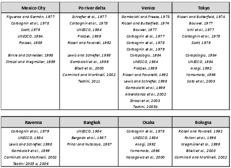
14 Murcia city, Barcelona, Granada, Almeria (Spain) and many other areas in the world. Some references are reported in Tab. 2.1.
Table 2.1: Historical cases of subsidence
In some cases, subsidence can manifest itself as catastrophic collapsing, called sinkholes, often dangerous for human life (Guerrero et al. 2008; Gutiérrez et al., 2008, 2009, 2011; Galve et al. 2009). They can be provoked by karst processes (consisting in the dissolution of limestone, dolomite, marble, or any other water-soluble rocks) or by piping phenomena. In the first case, between the countries affected by these
kind of phenomena, it is possible to cite Florida, Texas, Mexico, but also several areas in Italy (Nisio, 2004; Caramanna et al., 2008), like the Salento Peninsula (Polselli, 2005; Castiello, 2010), Toscana region (D’Amato Avanzi, 2004), Campania region and the famous S. Vittorino plain (Rieti).
The phenomenon of "soil piping" consists of the excavation of tunnels and cavities along the water preferential flow paths. The most famous cases of piping sinkholes are that occurred in Guatemala City in
2007 and 2010 in the Quaternary volcanic deposits. Here the leaking water mains progressively eroded and removed coarser materials, creating large underground voids. Other examples of piping sinkholes occurred in Italy in 2002 and 2006 in Telese Terme (Calcaterra et al., 2009).
Mexico City Po river delta Venice Tokyo
Figueroa and Germán, 1977 Schrefler et al., 1977 Gambolati and Freeze, 1973 Ricceri and Butterfield, 1974 Carbognin et al., 1978 Carbognin et al., 1978 Ricceri and Butterfield, 1974 Bouwer, 1977
Scott, 1979 UNESCO, 1984 Bouwer, 1977 Ishii et al., 1977 UNESCO, 1984. Placzek, 1989 Carbognin et al., 1977 Carbognin et al., 1978
Placzek, 1989 Ricceri and Favareti, 1992 Carbognin et al., 1978 Scott, 1979 Carbognin et al., 1979
Birkle and Schneider, 1998 Lewis and Schrefler, 1998 Corapcioglu, 1984 Corapcioglu, 1984 Strozzi and Wegmüller, 1999 Gambolati et al., 1999 UNESCO, 1984 UNESCO, 1984
Bitelli et al., 2000 Placzek, 1989 Akagi, 1992 Carminati and Martinelli, 2002 Ricceri and Favaretti, 1992 Yamamoto, 1996
Teatini, 2011 Lewis and Schrefler, 1998 Sato et al., 2003 Gambolatti et al., 1999
Alberotanza et al., 2002 Strozzi et al, 2003
Teatini, 2005b
Ravenna Bangkok Osaka Bologna
Carbognin et al., 1979 UNESCO, 1984 Carbognin et al., 1978 Ricceri and Favareti, 1992 UNESCO, 1984 Bergado et al., 1987 UNESCO, 1984 Folloni et al., 1996 Lewis and Schrefler, 1998 Prinzl and Nutalaya, 1987 Akagi, 1992 Wegmüller et al., 1999
Gambolati et al., 1999 Yamamoto, 1996 Bitelli et al., 2000 Carminati and Martinelli, 2002 Nakagawa et al., 2000 Carminati and Martinelli, 2002
Chapter II. Subsidence
15 Sinkholes can also have an anthropic origin and be correlated to land-use practices, like in the case of Palermo (Sottile, 2010) and Naples (South Italy) where are due to the presence of anthropic cavities; or
they can be originated by groundwater pumping and by construction and development practices; i.e. mining activities, (Pipia, 2007a; Yerro et al., 2014).
2.3. DInSAR monitoring of subsidence phenomena
The Advanced DInSAR Interferometry techniques has been used to monitor subsidence phenomena in many works (e.g.: Teatini, 2005; Cascini et al., 2006, 2007a,b; 2013; Marturià et al., 2006; Galloway and Hoffmann, 2007; Stramondo, 2008; Herrera et al., 2009; Ashrafianfar et al., 2011; Calderhead et al., 2011; Gutiérrez et al., 2011; Tomás et al., 2010, 2012; Raspini, 2013; Yerro et al., 2014). In particular, SAR
processing results, obtained through various A-DInSAR algorithms, proved to be helpful to the phenomenon analysis and to the related risk mitigation.
In the case of subsidence due to groundwater withdrawal, DInSAR displacement estimation resulted particularly effective to the phenomenon analysis and to achieve comparisons between the water level
measures and the consequent produced displacements. In many case, DInSAR data allowed the calibration of subsidence models: hydrological, geotechnical and structural models.
2.3.1. Hydrological models
In Galloway and Hoffmann, (2007) DInSAR, data have been used in a hydrogeological application, resulting very effective in the analysis, monitoring and simulation of the groundwater flow, of the
aquifer-system compaction and of land subsidence. In particular, DInSAR displacements reached to define the material and hydraulic heterogeneity of deforming aquifer-systems and to estimate system properties (e.g. storage coefficients and hydraulic conductivities).
The storage coefficients represent physical properties that characterize the capacity of an aquifer to release
groundwater. In particular, Sk is the aquifer system skeletal storage; it is function of the thickness of the aquifer system b (eq. 2.1) and of the skeletal specific storage Ssk
= ⋅ (2.1)
and represents the volume of water released from storage per unit decline in hydraulic head in the aquifer, per unit area of the aquifer. In other words, it represents the deformability of the aquitard, varying with the
16 In the case of water overexploitation, the water level could exceed under the historical minimum (hp) and,
consequently, the pre-consolidation pressure, by means of the highest pressure suffered by the soil along its life, could be overcome. In this case, a part of the produced deformation is not recoverable and the water released from storage derives from an inelastic compaction of the aquitard. Fine-grained sediments that constitute the confining and interbedded aquitards may deform both elastically and an-elastically.
The aquifer skeletal storage Sk can be calculated (Riley, 1969) as:
=∆
∆ (2.2)
Where Δb represents the change in the aquifer thickness (by means the subsidence) and Δh the water level
variation. Riley proposed a graphical methodology to the skeletal storage computation, consisting in the determination of the slope of the branch of the stress–strain curve
(elastic or anelastic). This methodology has been used by several authors (Hoffman, 2003; Hoffmann et al., 2003; Schmidt and Bürgmann, 2003; Galloway
and Hoffmann, 2007; Tomas et al., 2010), where, in particular, Δb computation, obtained from the DInSAR displacement measurements in conjunction with piezometer ones,
allowed to find spatially variation of storage coefficients and verify the elastic behaviour of the aquifer.
As reported from Tomas et al. (2010),
this approach permitted to implement a numerical model for the subsidence prediction in Murcia city and, in particular, to achieve an-elastic coefficient from the strain-stress curve
Figure 2.1: A) LOS-projected subsidence and piezometric data used for the calibration and prediction. B) Strain–stress curve
Chapter II. Subsidence
17 (Fig. 2.1), obtained thanks to the DInSAR displacements. It is showed a water level drought, occurred in the period 1993-1995, produced displacements measured through SAR data. The CPT displacement time series
corresponding to the 1993–1995 period were used to calibrate a one-dimensional subsidence model and to retrieve the soil physical parameters. In this period the historical piezometric minimum was overpassed, so the an-elastic storage coefficient has been achieved. Using 139 oedometric tests performed following the UNE 103-405-94 (UNE, 1994) procedure, the elastic storage coefficient was computed as a percentage of an-elastic storage coefficient (Skv). In fact, the ratio (which resulted equal to 15% on average) between the
swelling index Cs (slope of the oedometric unloading–reloading branch) and the compression index Cc (slope of the oedometric virgin compression branch), could be considered as that of the Ske and Skv parameters. The so obtained model was successfully used to predict the deformations for the period 1993–2007.
2.3.2. Geotechnical models
DInSAR measured displacements has demonstrated to be useful also for the calibration or validation of
more sophisticate subsidence geotechnical models, like referred by Herrera et al. (2009a;b), Calderhead et al. (2011).
In Herrera et al. (2009b), in particular, it was demonstrated that the consolidation process is the most important phenomenon to be simulated in Murcia city. Here, the elastic constitutive relation proposed by Biot (1941) was chosen to model the soil behavior and the possible occurrence of plastic deformations was
not taken into account. Through the comparison between the model results and DInSAR displacement time series, an average absolute error of 5.5 ± 4.7 mm (in the period 1995-2007) was achieved.
This result demonstrated the potential of A-DInSAR techniques to validate subsidence prediction models as an alternative to using instrumental ground-based techniques for validation.
2.3.3. Structural monitoring
Some other interesting applications of DInSAR displacement measurements have provided the monitoring of buildings affected by structural problems related to the subsidence, due to water over-exploitation. In particular, Cascini et al. (2006, 2007b, 2013), Tomás et al. (2012), used geotechnical criteria to characterize potentially risky situations, identifying buildings where damage related to the DInSAR
18 In Cascini et al. (2006), in particular, DInSAR results allowed to investigate the relationship between the
magnitude of absolute and differential settlements and the occurrence of building damage. In Figure 2.2 the magnitude of the deformation gradient has been compared with the localization of recorded damages.
Above all, it has been noted that the main directions of damage, often consisting of vertical cracks, seemed to be almost normal to the gradient deformation direction.
Figure 2.2: Deformation gradient map of the investigated area and spatial distribution of damaged buildings (Cascini et al. 2006).
In Tomàs et al. (2012), DInSAR data were used to understand the mechanism that affects the Santa Justa and Rufina Church in Orihuela city (Spain), related to the subsidence due to groundwater withdrawal. The geotechnical characterization of the substrate properties and geometry beneath the church, linked to a detailed forensic analysis and examination of the historical reports concerning the church pathologies,
allowed to interpret the DInSAR interpolated map.
Chapter II. Subsidence
19
2.3.4. DInSAR monitoring of subsidence phenomena in Italy
An important contribution to discover the potentiality of DInSAR monitoring systems was brought by the "The Extraordinary Plan of Environmental Remote sensing” (EPRS-E, 2009). In this project, the available ENVISAT images have been processed in the whole Italian territory and made available through the website
of the National ministry of environment (MATTM). Furthermore, the processing of high resolution Cosmo Sky-med images acquired by last generation sensors has been achieved for three test sites Bologna, Venice and Palermo to analyse advantages and limits of this technique.
Venice, is affected by subsidence due to the water overexploitation. In order to monitor the displacements a levelling network was installed in 2007 and implemented in the last years, introducing,
recently, also a DGPS network (Tab. 2.2).
An area of 5x3 Km has been chosen to test the DInSAR data, achieved from the processing of X-band Cosmo Sky-med images through the Persistent Scatterer Pairs (PSP)-IFSAR technique (Costantini et al. 2008).
Here, 38 images acquired in ascending orbit and 50 in descending orbit in 2009-2011 (having a revisit time
of 11 days) have been processed.
The comparison between in situ and radar data has been carried out considering a buffer of 100 m from the 18 GNSS network vertex and computing the average velocity between the PS within the buffer.
20 The reported velocity values have been compared with that of the topographic surveys obtaining an error
of 0.5 mm/year and 1.3 mm/year for the ascending and descending acquisition geometry.
Bologna is affected by subsidence due to the water overexploitation. Also in this case, it has been chosen to test the Cosmo Sky-med products because of the great amount of in situ monitoring data. Here,
in fact, topographic measurements (GNSS network, Tab. 2.3) have been achieved between 1993 and 2001 and after 2007 (ERGPS7). Starting from these networks, a topographic campaign has been performed in an area of 165 Km2 (21x12 Km).
Here, 36 CSK images acquired in ascending orbit between 2009 and 2011 and 40 CSK images in descending orbit between 2008-2011 (having a revisit time of 24 days) have been processed through the SqueeSAR™
technique (Prati et al. 2010).
Using the same criteria described in Venice case study, an error of 2.6 mm/year and 2.3 mm/year for the ascending and descending acquisition geometry have been obtained.
Table 2.3: Comparison between mean velocities of the displacements measured by SAR and in the 24 vertex of the GNSS network of Bologna (EPRS-E, 2009).
Chapter II. Subsidence
21 For this reason, their use is normally coupled with the “in situ” monitoring to perform an integrated monitoring system. Several other examples can be found in Avallone et al. (1999); Baldi et al. (2009);
Teatini et al. (2006; 2011).
Referring to Avallone et al. (1999) they used DInSAR method for measuring the ground displacement changes inNeapolitan volcanic area. The DInSAR method, applied to radar images in the period comprised between 1993 and 1996. It confirms the significant subsidence still occurring in the Campi Flegrei area after the last 1982-1984 seismic and inflation sequence. This subsidence is also observed by classical
levelling surveys. The best interferogram, corresponding to the 1993-1996 period shows that the centre of the Campi Flegrei caldera subsided by about 26±9 mm/year during this three years interval. This result is consistent with the value of 100±5 mm obtained from the routine levelling surveys carried out by observatories Vesuviano in the same area. The modelling of the fringe pattern using the Mogi's model
predicts a source centred offshore eight hundred meters Southwest of Pozzuoli at about 2.7 km depth. The modelled volume decrease at depth is 0.8x10⁶ m3/year and the maximum subsidence predicted by the model is 78 mm.
The other important subsidence case study in Italy is represented by Ravenna.
Ravenna is affected by subsidence provoked by the aquitard and reservoir compaction; this is caused, respectively, by extensive groundwater withdrawals from the unconsolidated Quaternary basin and gas production from a number of pre-Quaternary pools scattered over the area. Water pumping paralleled the post-war industrial development of Ravenna until the middle seventies when consumption was drastically curtailed owing to the economic crisis and the activation of a new aqueduct.
The discovery (made in 1952) of severalunderground gas pools and the construction of a big commercial
port promoted rapid industrial and agricultural development in the neighbouring area. Therefore, after the Second World War, Ravenna experienced a new flourishing era. The major environmental cost paid for this outstanding growth has been a pronounced land settlement as a direct consequence of groundwater overdraft and gas removal. Subsurface water has been extensively withdrawn since 1950 to cope with the
growing demand for fresh water for civil, industrial and agricultural use. The problem became critical in the middle 1970s because of obvious large damage to the infrastructure and the monumental heritage that was increasingly subject to flooding during the most intensive meteorological events, the highest Adriatic tides and the longest rainy periods. One major controversial issue was apportioning the responsibility for land subsidence between gas and water pumping. Overall geodetic evidence pointed out a joint
22 The extraction of gas in Ravenna Terra field reaching a peak withdrawal of about 7 million Sm3 per day in 1966 and being practically stooped in 1982. Water has also been heavily extracted from the upper aquifers
in the period 1950-1973. After that pumping was drastically reduced and finally stopped. Both extractions have contributed to surface settlement, however the one caused by gas extraction decreases rapidly away from the reservoir, while that due to water withdrawal is spread all over the area (Schrefler et al. 2008). They concluded that there is direct and indirect evidence that the reservoir sands of this region show the
typical features of soils in presence of capillary forces.
The exploitation of several reservoirs is currently under way and the search for new fields is still in progress. Geodetic records indicate that the maximum cumulative subsidence over the period 1950-1986, including a natural geologic settlement of perhaps 2 mm/yr, has been 1.30 m in the industrial zone of Ravenna. In 1980 the municipality promoted a reconnaissance study with the primary aim of providing the information base
needed to reconstruct the actual occurrence, understand correctly the physical behaviour and produce the essential input data to a mathematical model which realistically relates the subsidence of the city to groundwater withdrawal and gas removal with an emphasis on their respective influences.
All of the previous studies on the Ravenna subsidence are dealing with mathematical 3D models, geodetic, hydrogeological, seismic and environmental measurements. Gambolati et al. (1991) reported that a borehole (RA1) drilled down to 500 m by AGIP (Italian National Oil Company) and Ravenna municipality give
a detailed lithological description. Several analyses have been performed on the borehole core samples, including sediment grain size analysis, specific weight of the porous bulk, specific weight of the grains, Atterberg limits, natural water contents, oedeometer tests on soil consolidation, and permeability tests with either constant or variable load. The oedeometer tests were performed on cohesive as well as granular sediments to assess the vertical soil compressibility. The range of stress explored was between 0.5
and 82 kg/cm 2, taking care to exceed the in situ consolidation stress by at least 2 times. Gambolati et al. (1991) noted that the compressibility decreases with depth and the difference between the sand and clay compressibilities become smaller for larger values of depth. Values of compressibility appear to be
between 4 X 10⁻³ and 6 X 10⁻⁵ Kg/cm2.
The results from the three-dimensional numerical simulations, performed with the aid of mixed finite element, finite difference and integral models, show that the primary responsibility for the regional land sinking should be placed on the subsurface water overdraft which occurred until the middle 1970s. Gas withdrawal plays a role restricted to the area overlying each reservoir with a magnitude depending on the depth of burial, thickness of mineralized rocks and overall volumetric production. A major environmental
Chapter II. Subsidence
23 Figure 2.3: Vertical soil compressibility versus depth as obtained from oedometer tests carried out on core samples RA1
(after Gambolati et al., 1991).
Teatini et al. (2005) studied the Ravenna land subsidence by implementing the levelling measurements
carried out since 1987 in a GIS environment. They noted that land subsidence increased in the last decades due to groundwater withdrawal from a well-developed multi-aquifer system underlying the coastland and, subordinately, to gas extraction from deep reservoirs scattered through the area and still productive nowadays. Land settlement occurred at anaverage rate of about 5 mm/year until World War II, increased
greatly up to an order of magnitude in theRavenna industrial area, mainly due to the aquifer over-draft in connection with the post-war economic growth. The construction of new public aqueducts using surface water during the late 1970s and 1980s has significantly reduced the subsurface water consumption and the settlement rates to the pre-war values. However, local areasof significant land subsidence are still present because oflocal groundwater pumping and the development of deepgas reservoirs. The cumulative land
settlement, accounting for both the natural and the anthropogenic components, has achieved the alarming value of 1.6 m from 1897to 2002 in the industrial area located between the city andthe seashore, with the coastland and the historical centre settled by more than 1 m. Although the mainland appears to be substantiallystable to date, subsiding rates up to 15 mm/year recorded between the Lido Adriano and Lido di Dante villages facing Ravenna and in the northern area separating the Comacchio Lagoon from the
24 Figure 2.4: Land subsidence versus time along the shoreline of the Ravenna Municipality obtained from the GIS slicing
of the levelling data (Teatini et al., 2005).
As referred by Teatini et al. (2006) mentioned that Anthropogenic land subsidence due to groundwater overdraft has caused serious and costly damages to theEmilia-Romagna coastland, a low-lying area facing
the Adriatic Sea south of the Po River delta, Italy.Both areal pattern and time behaviour of the occurrence are reconstructed over the last 50 years and predicted until 2016 by a 3-D FE model. The model addresses the pumping-related hydrodynamics of the complex multi-aquifer system underlying the study area and predicts ground surface displacements. The simulations have been performed using the most recent and advanced 3-D interpretation of the aquifer geology. However, the paucity of data on the pumping rate
distribution does not allow for local in-depth investigations. The aquifer/aquitard hydraulic conductivity and compressibility have been estimated by in situ and laboratory tests and calibrated by a coupled iterative procedure matching the historical piezometry, land subsidence, and multi-aquifer system compaction over the study area. The hydrologic and geo-mechanical models have been calibrated over,
Chapter II. Subsidence
25 anthropogenicland subsidence experienced by the Emilia-Romagna coastland after World War II. Over the last two-three decades, when a general head recovery has been observed within thepumped formations,
residual land settlement measured allover the region appears to be accounted for by the delayed aquitard consolidation.
In the same article it has been mentioned that a most fundamental parameterfor a reliable modelling of land subsidence due to fluid withdrawal is the uniaxial vertical compressibility (CM) which controls the amount of vertical soil compaction caused by pore pressure drawdown. Pumping testscan provide some in
situ estimates of the aquifer elastic storageS. As reported in eq.2.1, dividing the S values by the aquifer thickness, a specific elastic storage Ssis obtained. In this case, a specific elastic storage between 10
-4 -10-5 m-1 has been found. Ss is related to the vertical compressibility by the relationship:
= ( + ) (2.3)
Where and are, respectively, the groundwater specific weight and volumetric compressibility ( = 0.432 X 10⁻⁸ kg/m2) and = 0.3 the medium porosity. Hence the in situ measurements provide a sand compressibility thatis from 5 to 10 times smaller than that found from laboratory tests, displayed in Figure 2.3, consistent with the most recent findings that laboratory tests tend to overestimate the actual CM.
Teatini et al. (2006) concluded that Groundwater withdrawal from the upper multi-aquifer system is the main responsible for the anthropogenic land subsidence experienced by the Emilia-Romagna coastland after World War II. Over the last two-three decades, when a general head recovery has been observed within the pumped formations, residual land settlement measured all over the region appears to be accounted for by the delayed aquitard consolidation.
Baldi et al. (2009) studied the land subsidence in the Po plain using regional and local networks of continuously operating GPS stations (CGPS) distributed in the northern-central part of the Italian peninsula. They mentioned that over the last century the Ravenna area has been affected by a widespread land
subsidence of both natural and anthropogenic origins; initially, it was of the order of a few mm/yr, but the extensive groundwater withdrawals started in the early 1950s and the beginning of gas production from onshore and offshore reservoirs, discovered in the area in 1952, increased the subsidence up to 110 mm/yr (Gambolati et al., 1991). Following the late 1970s, the water withdrawal was drastically reduced due to the economic crisis and the activation of a new aqueduct, inducing an abrupt decrease in the land subsidence