Ontologies Models Cohesiveness: A First
Assessment of Integration
Mercedes Vitturini
1and Pablo R. Fillottrani
1,21
LISSI - Laboratorio de I+D en Ingeniería de Software y Sistemas de Información, Departamento de
Ciencias e Ingeniería de la Computación, Universidad Nacional del Sur
2
Comisión de Investigaciones Científicas de la Provnicia de Buenos Aires
Abstract—Multiple ontologies over shared domain has been produced in the geographic ontology-design field for GIS environments. In geneal, each GIS solution has its own data model or application ontology. Ontol-ogy model mapping could provide a common language from which several systems could exchange information in a semantic form. In this paper we present a novel technique that collaborates with the task of analyzing the degree of cohesion between ontologies and servers in order to anticipate the quality resulting from the integration process.
Keywords: Ontology Integration, Interoperability, GIS, Ontology
I. INTRODUCTION
Geographic Information (GI) accessible on line covers a range of systems types, such as Geographic Information Systems (GIS), Spatial Data Infrastruc-tures (SDI), and Location Based Mobile Systems (LBMS). Private companies and national and in-ternational research and education organizations are some of their major customers. Generally, GI is unwieldy, has a complex structure and usually is distributed by theme over different servers. Many new users consider attractive the possibility of use GI services. If a new GI service is needed, an extra cost to consider is the acquisition of geographic data when unavailable. Sometimes it occurs that the GI data on a topic already exists in some previous development, for instance, information about “routes and roads”. The possibility of sharing information and services means lower costs and start-up times, as well as improvement of information reliability. In the last few years, several software development problems have been faced with the need of sharing and reusing knowledge acquired for a specific do-main. This is accomplished by the Semantic Web and it is linked to the notion of interoperability [Gua98], [ISO94], [OGC94]. The goal is to have an unambiguous knowledge of the Web that can be interpreted by automated agents. In particular, there is a need of a Geospatial Semantic Web [Ege02] on a framework comprising various thematic spatial ontologies. The design of some kind of solutions to GI heterogeneity problems is needed in order to
share GI. In this way, data could be processed and interpreted by remote systems. Ontology semantic integration is based on several ontologies working as mediators in the communication between systems. For a successful mediation, a semantic mapping between ontology models is required. This task will be effective as long as the concepts of different ontologies are really comparable. In this paper we propose a simple technique based on relationships of concept sets that could help to anticipate the effectiveness of this communication process.
II. HETEROGENEITY INGEOGRAPHIC
INFORMATION
For years, each new GIS development defined its own models of storage and visualization for spatial data, in addition to their conceptual data models. GI format diversity involves interoperability problems between GIS’s.
A. Context
Heterogeneity Application A1 Application A2 Syntactic A1represents A2represents
the areas the areas according to according to Bahía Blanca Bahía Blanca population population density under density under the spatial the spatial vector model. raster model. Structural A1represents A2represents
the areas the areas according to according to Bahía Blanca Bahía Blanca population with population with details about details about the distribution types of of public constructions services. -buildings,
private neighborhoods, etc.-. Semantic A1represents A2represents
the areas the areas according to according to Bahía Blanca Bahía Blanca population population density. The unit density. The unit of measurement of measurement used is number used is number of inhabitants. of family groups.
TABLE I
EXAMPLES OF SYNTACTIC,STRUCTURAL,AND SEMANTIC HETEROGENEITY
such as distance and orientation. Topology refers to properties like proximity, adjacency, inclusion, and connectivity that remain invariant to morphological changes of scale or projection.
B. Heterogeneity Levels in Geographic Data
In any two given representations of a geographic problem, we will distinguish the following types of heterogeneities [LGMR05], [WVV+01]:
• Syntactic Heterogeneity: for a single phe-nomenon each solution provides different for-mats and space representation models -vector or mosaic-, and/or different coordinate representa-tion systems.
• Structural Heterogeneity: refers to the “form” that each solution chooses in order to represent the same phenomenon. Many differences are expected to exist in terms of structure between models.
• Semantic Heterogeneity: it occurs when distinct solutions interpret different meanings for the same phenomenon.
Table I illustrates all these types of heterogeneities. The solution to GI heterogeneity problems encour-ages research in the field of Computer Sciences.
III. PROPOSALS ONGEOGRAPHICINFORMATION
INTEGRATION
Research work to make progress towards GI inte-gration is addressed in two different ways. On the one hand, there is research that defines standards
that normalize representation models for spatial data. On the other hand, there is research on semantic difference solutions that are generally linked to the definition of ontologies that provide formal specifi-cations and tools for automatic integration. Defining integration rules is only possible if the meaning of data is known.
A. Standards in Geographic Information
The international standards for geographic data and services are primarily concerned with the Open Geospatial Consortium (OGC) [OGC94] and the Technical Committee of Standardization on Geomat-ics and Geographic Information ISO/TC211 [ISO94]. OGC is an international consortium. Its participants represent business companies, government agencies, and universities. It has a consensus process to develop interface specifications applicable to open source geo processing systems. OGC solutions are referred to as Open GIS Specifications and pro-vide interoperable solutions to make the GI “geo-available”. OGC mission is to lead to development promoting the use of architectures that allow for the integration of geographic applications.
Meanwhile, the International Standards Organiza-tion (ISO) established the Technical Committee for Standardization in Geomatics and Geographic Infor-mation ISO/TC211 to be responsible for defining reference standards for digital GI and for the transfer of data and services. The ISO 19100 family is a set of standards related to geographic features. These regulations deal with methods, tools, and services for managing, acquiring, processing, analyzing, access-ing, presentaccess-ing, and transferring digital GI among different users, systems, and locations.
OGC members also participate in ISO/TC211 through the Joint Consultative Council ISO/TC211-OGC. Its mission is to coordinate the efforts of both organizations and to ensure a single standard reference.
B. Ontology Models
Ontologies unify the interpretation of concepts and terms so that such interpretation can be unique [FEA+
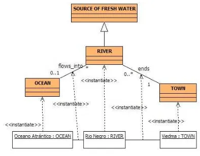
Fig. 1. Instantiation Feature-Ontology
and its relationships. The notation used is proposed by UML. In the example there are classes (color) which define the common properties of the elements of the same type, and instances (white) representing a particular concept, occurrence or instance. You can see a hierarchical relationship between classes
SOURCE OF FRESH WATER and RIVER specified
byis_adistinguished relation. Other relations in the example are:flow_into, which specifies that instances of RIVER lead to instances of OCEAN and ends which represents a TOWNwhere a RIVERends. The link between instances and their respective class or relation is represented by the stereotyped dependency << instantiate >>. These definitions make it possible to achieve the following basic conclusions:
1) ‘Río Negro’ is a RIVER. 2) ‘Atlántico’ is an OCEAN. 3) ‘Viedma’ is a TOWN.
4) ‘Río Negro’ flows into ‘Atlántico’. 5) ‘Río Negro’ ends in ‘Viedma’.
And these more elaborated implicit conclusions: 1) ‘Río Negro’ is a SOURCEOFFRESHWATER. 2) ‘Viedma’ is near the ‘Océano Atlántico’
OCEAN.
3) ‘Viedma’ has a SOURCEOFFRESHWATER. A benefit of having this explicit representation for instances and their binding model is that an auto-mated agent could reach to these same conclusions, as if it could understand or reason.
IV. ONTOLOGY-BASEDARCHITECTURE
INTEGRATIONMODEL
As stated, to find and recover efficiently distributed heterogeneous GI is a key factor. Standards pro-mote interoperability and classification for GI by catalogs. However, difficulties caused by semantic heterogeneities are still a challenge in integrating distributed open environment GI.
In the field of ontology, there are different ontolo-gies built for various application domains. They vary
in the level of detail they express. Ontologies can be organized according to their degree of generality as follows [Buc09], [WVV+
01]:
• Generic Ontology (Top-Level): captures the gen-eral purpose knowledge, regardless of any par-ticular domain, such as space, time, event, ac-tion, etc. It is expected that these ontologies will be adopted by a large community of users. • Domain Ontology and Task Ontology: define the
particular knowledge of a domain (for example, medicine, geography, etc.) or a specific activity (for example, trade), describing their vocabulary through the specialization of the terms intro-duced in the high-level ontology.
• Application Ontology (Low-Level): captures the knowledge needed from an individual system or application. It describes concepts that depend on both the domain and activity ontology, that are often specializations of the two previous kinds of ontology.
The options for ontology-based semantic inte-gration systems are arranged into different styles [CSH06], [WVV+01]. One style considers a single
ontology shared by all applications. Another defines multiple ontologies along with integration functions between pairs. A more flexible option is to combine the two previous styles. The latter proposal of inte-gration, based on hybrid ontology, establishes a do-main ontology(DO)shared by a community of use that provides the definition of its basic terms (prim-itive). Hybrid ontology assumes that the common semantics of its primitives is known and understood by the community. Independently, each supplier is free to define his or her own OGI Si application ontology. Furthermore, the data model of each GIS solution plays the role of application ontology. Be-sides, the communication interface or “mapping” betweenDO ontology andOGI Si ontology should
be established. This kind of semantic integration provides a flexible framework that respects applica-tion ontology and complies with every need, keeping the various OGI Si ontologies comparable [Buc09],
something crucial when making semantic searches or requiring information integration services.
V. COHESION BETWEENONTOLOGICALMODELS
scheme aligned to the GFM standard [ISO05] and to define them(OGI Si)→DO mapping function.
Thus, the problem of solving semantic heterogene-ity among different GIS solutions turns into defining the correct m(OGI Si) → DO mapping function,
with the added advantage of having concepts for-malized by an ontology. However, the effectiveness of the mapping, and thus the result of integration, depends on the degree of cohesion between the world shaped byDO and the world shaped byOGI Si.
This work presents a technique used to measure the degree of interrelation or cohesiveness between DO ontology and OGI Si application ontology. In particular, we want to measure the level of cohe-siveness between concepts defined in OGI Si and concepts defined by DO. In order to progress with rigor, we present the following definition [Vit09]: let CGI S be a set of concepts defined by OGI Si
ontology and CDO the ontology concepts defined
by DO ontology. It is possible to approximate the cohesiveness between the application model and the domain ontology by formalizing the following mem-bership relations between sets:
1) CGI S⊂CDO∧ |CGI S| ≈ |CDO|, presents the
situation of domain ontology with maximum coverage and high accuracy. This is the optimal relation between DO and OGI Si concepts.
Domain ontology concepts cover the concepts required by the application. We can say that DOcontains definitions and semantics close to
the application problem. For example, suppose thatCDOdefines the concept LOCATIONwhile CGI S provides the definition for a concept named CITY. In all instances, city inCGI S is covered by the concepts LOCATION in CDO and is hoped that its semantic definition is close.
2) CGI S ⊂ CDO ∧ ¬(|CGI S| ≈ |CDO|),
repre-sents a situation with high coverage but low precision. The relationship between concepts in domain ontology and the concepts in the GIS application can be defined as “good”. In this case, DO also covers the concepts required by the application. However, the se-mantic content in DO is not as close to the semantic content required by the GIS, and the mapping shall be potentially less accurate. For example, CDO has a definition for a concept SPECIESwhileCGI Sconsiders a definition for a concept NATIVESPECIES. It is expected that the description for NATIVESPECIESinOGI Si
will be more refined than the characterization of the concept SPECIES provided byDO on-tology.
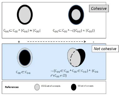
3) CDO ⊂ CGI S. Concepts in DO do not
cover the universe of concepts required by the OGI Siapplication. There are concepts defined
[image:4.595.310.537.67.249.2]by the GIS application for which there are
Fig. 2. Relationship between Domains and GIS Ontology Concepts
no concepts to map in DO. The semantic relationship between OGI Si andDO is “not good”. The greater the number of concepts excluded, the worse the cohesion ratio relation is. For exampleCGI S contains a definition for SITE whereasCDO defines LOCATION. There
are site elements inCGI S which do not map any location ofCDO and, thus, will be lost in
the mapping process.
4) ¬(CGI S ⊂CDO∧CDO ⊂CGI S)∧(CGI S∩
CDO). Both ontologies contain concepts that
do not have a correspondence in the other uni-verse, although they share a subset of concepts. This is the worst relationship scenario among ontologies. For example, consider aCGI S set
which defines concepts such as SOURCE OF FRESH WATER, while CDO defines concepts such as STREAM OFWATER. There are ele-ments in CGI S such as “reservoir” which do not map any concept in STREAMOFWATERin CDO. Conversely, the semantic definition for the elements in DO, such as “seas” are not represented in theCGI Sof the GIS application.
Figure 2 shows a graphic for the above items using traditional set representations. The kind of relationship between sets of concepts has an impact on the effectiveness of the mapping process from OGI Si to OD. We can state that the mapping function looses accuracy as we move away from the situation in the states in 1, being 4 the least desirable alternative.
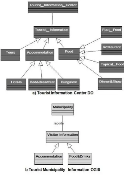
Fig. 3. DO&OGI SConceptual Model
OGI SConcept DOConcept Map Relation Municipality Tourist (.4.) Bad
Information Center
reports offers (.1.) Very Good Visitor Tourist (.1.) Very Good Information Information
Accommodation Accommodation and (.2.) Good its specializations: the map depends Hotels, Bungalows uppon the existence Bed&Bredfast of a discriminator Food&Drinks Food and its (.3.) Not Good
specializations: the map is partial Restaurant, Typical and depends uppon Dinner&Show the existence of Fast Food a discriminator
TABLE II
ANALYSIS OF RELATIONSHIP BETWEEN CONCEPTS
an automatic ontology mapping, we could apply the analysis of relationship between concepts present in both ontologies under our proposal. Results are shown in Table II.
[image:5.595.76.282.410.549.2]As shown, in this case is difficult to ensure a good mapping relation between both models. Some possible solutions are: enrich de OGI S, if it is possible, and/or define manually mapping function. Surely theOGI SandDOontology were defined in-dependently over a shared domain and requirements. If the case of new GIS application solution, the best option is to define an application model according to existingDOontologies which ensure best results [Vit09].
VI. ANALYSIS OF THEPROPOSAL
In order tosemantic queriesandontologies reuse, is needed to align application ontologies and domain ontologies contents. Generally, a domain expert must determine the correlation between concepts of these ontologies. Doing matching task manually is time-consuming, tedious, and error-risk process. To reduce this effort, many approaches to semi-automatically determine element correspondences were developed. As example, COMA++ (Combining Matchers) plat-form [Do06], present a generic and customizable sys-tems for semi-automatic schema matching, allowing flexible combination of different match algorithms and a way for solving the match task in stages. On the same idea GEN-MAPPER (Generic Mapper) [Do06], present an approach for integrating hetero-geneous web data sources using correspondences between objects. GEN-MAPPER explicitly captures existing relationships between objects to drive data integration and combine annotation knowledge from different sources. A generic schema is used to uni-formly represent object data and correspondences.
Other research is iPrompt and AnchorPrompt [NM03], a suite of tools for managing multiple on-tologies. This suite provides users with a framework for comparing, aligning, and merging ontologies, maintaining versions, translating between different formalisms with support to semi-automatic ontology merging: iPrompt is an interactive ontology merging tool that guides the user through the merging process, presenting suggestions for next steps and identify-ing inconsistencies and potential problems. Anchor-Prompt uses a graph-based algorithm for finding correlations between concepts in different ontologies which provide additional information for iPrompt. It takes as input a set of pairs of related terms or anchors from the source ontologies. The requirement for “align concepts” between diverse sources, may mean align the schema or metadata, translating infor-mation from one structure to another, or may mean align data o content, when data gathering of diverse sources is needed.
A survey and a taxonomy that covers many of existing approaches of match partially automa-tion is found in [RB01]. The work distinguish between schema-level and instance-level (instance data o schema level information), element-level and structure-level (simple attributes or complex schema structures), and language-based and constraint-based matchers (based on names or based on keys and relationships).
conceptual level. As described in the example devel-oped in Figure 3 and Table II, the method includes identifying concepts in the ontology source -concepts and relationships- and classifying the mapping re-lationship (1 to 4) with regard to the concepts of the target ontology. As far as the target ontology covers the concepts of source ontology, it is expected that mapping to shared ontology shall be possible without loosing information. In our example, we see that between the two models there is a “very good” relationship with the DO ontology for the concepts “Visitors Information” and“reports”; a “good” rela-tionship between “Accommodation” concepts, with a different and even impossible way of mapping the system used to classify them; and a “bad” and even impossible way of mapping for instances of the remaining concepts.
VII. CONCLUSIONS
Continuous progress in Information and Commu-nications Technologies (ICTs) offers the possibil-ity of having a great amount of heterogeneous GI available. In current research in the field of Com-puter Sciences on the topic of ontology, researchers are looking for ways of representing and accessing knowledge in digital GI towards promoting interop-erable systems. Meanwhile, researchers in geography ontology-design field have developed ontologies in many domain areas. The distributed nature of on-tology development has led to a large number of ontologies covering overlapping domains.
Ontology is a kind of tool that gains importance when looking for interoperability among heteroge-neous GIS and web applications. The style of hybrid ontology-based integration provides customers with a unified abstraction layer that allows for independence from the conceptual models of each service provider. In order to make this possible, we need to define the mappings between the various implementation models and shared ontology.
Much of the effort of the research community in Semantic Integration aims at developing techniques and automated tools to ensure successful results. In this paper we propose a novel technique based on set relations in order to measure the interrelation-ship between different data models and to foresee the result of the integration process. As long as the relevant concepts of the application conceptual model maintain a good cohesive relationship with domain ontology concepts, it is expected that the result of integration shall be acceptable and that no information shall be lost. In a future work, we intend to break down this first measure into specific and measurable sub-measures and accompany the proposal with automated tools that shall give a result that will allow us to measure its applicability.
REFERENCES
[Buc09] Agustina Buccella. Integración de Sistemas de Información Geográfica. PhD thesis, Departamento de Ciencias e Ingeniería de la Computación, Uni-versidad Nacional del Sur. Bahía Blanca. Argentina, 2009.
[CSH06] Namyoun Choi, Il-Yeol Song, and Hyoil Han. A sur-vey on ontology mapping.SIGMOD Rec., 35(3):34– 41, September 2006.
[Do06] Hong-Hai Do. Schema matching and mapping-based data integration. 2006.
[Ege02] M. Egenhofer. Toward the semantic geospatial web, 2002.
[FEA+02] F. Fonseca, Max J. Egenhofer, P. Agouris, C. Cmara,
Frederico Fonseca, Max J. Egenhofer, Peggy Agouris, and Gilberto Câmara. Using ontologies for integrated geographic information systems, 2002. [Gua98] Nicola Guarino. Formal ontology and information
systems. pages 3–15, 1998.
[ISO94] ISO/TC 211 Geographic information/Geomatics. Website, 1994. http://www.isotc211.org/.
[ISO05] Geographic information – rules for application schemas. International Organization for Standardiza-tion (ISO) 19109. Technical report, ISO/TC 211, 2005.
[LGMR05] P. Longley, M. Goodchild, D. Maguire, and D. Rhind. Geographic information systems and science. Wiley, John and Sons, Incorporated, 2005. [NM03] Natalya F Noy and Mark A Musen. The prompt suite: interactive tools for ontology merging and mapping.International Journal of Human-Computer Studies, 59(6):983 – 1024, 2003.
[OGC94] Open Geospatial Consortium, Inc. (OGC). Website, 1994. http://www.opengeospatial.org/.
[RB01] Erhard Rahm and Philip A. Bernstein. A sur-vey of approaches to automatic schema match-ing. The VLDB Journal, 10:334–350, 2001. 10.1007/s007780100057.
[Vit09] M. Mercedes Vitturini. Tesis de magister: Modelos de representación de información geográfica, 2009. [WVV+01] H. Wache, T. Vögele, U. Visser, H. Stuckenschmidt,
G. Schuster, H. Neumann, and S. Hübner. Ontology-based integration of information - a survey of exist-ing approaches. pages 108–117, 2001.