1
Urban sprawl and city compactness. A proposal for regional
sustainability indicators. Case study of the towns of Alcorcon and
Majadahonda (Comunidad de Madrid, Spain)
Author: Rivera Blasco, Darío (Universidad Politécnica Madrid, Spain)
Abstract: The main contribution of this research paper is to display a range of figures and values which could help urban planners to quantify the urban phenomenon of sprawl. In this way, after a rigorous analysis and comparison between a scattered urban fabric
(Majadahonda) and a compact urban fabric (Alcorcón), several possible indexes are established and characterized in order to verify the main hypothesis: in what extent land consumption and exploitation of energy resources are higher in a scattered urban fabric than in a compact one.
Keywords: Urban dispersion, unitary urban footprint, scattered suburbs, urban fragmentation, spatial segregation, land articulation, diffused city.
1. INTRODUCTION
Most of the time “Urban Sprawl” seems to be a blurred concept, related to low densities, spatial segregation and urban fragmentation. This paper suggests a definition of sprawl throughout different measuring systems based on urban parameters that can be easily
recognized. The main questions we will try to clarify along the present investigation will be: How much scattered (in terms of measure) can be an urban territory? And: What level of fragmentation can we expect to found there?
We will consider several indicators which will help us to operate with territorial features attached to a diffused urban area, in order to verify relations of land consumption per habitant in a scope of 2 and 5 times higher in towns with a scattered urban growth in contrast to those with a more compact urban growth. At this point, this research will focus in two cases of study. Two opposite urban models in the periphery of the city of Madrid, with moderate differences between them, will be analyzed. This analysis, now a preliminary one, should be carried in a deeper way in future investigations, in order to establish a more consistent scientific basis.
2 West sector inside the central almond of the city of Madrid. For the same land consumption (58 km2), the densities are different between these two models of urban growth: from 16 inhabitants/hectare in Sprawl areas to 180 inhabitants/hectare in the city core fabric, a disequilibrium which generates an ecological impact.
These results may lead us to the establishment of sustainability patterns for a specific geographical area between these two models of urban growth. A new concept of urbanism will arise, with the aim of improving the diffused city problem by the revitalization of public space, the implementation of a more compact urban fabric in order to reduce displacements across the city, the mixing of uses for increasing activity and a more pedestrian and cycle-based mobility, instead of the car massive-use of nowadays.
2. CASES OF STUDY AND INDICATORS CHOICE
Some geographical areas of the periphery of Madrid, with their spectacular processes of urban growth in the last three decades, constitute an extraordinary case of study in terms of
analyzing the logic of urban phenomena of sprawl and compactness at a metropolitan scale. By the one hand, the geographical area chosen for studying urban indicators of sprawl will be Carretera de La Coruña Corridor. This urban corridor presents a large amount of single-family homes (since the beginning of the 1970s), an intensive use of private transport with a great investment in road transport infrastructures, and a lucrative land exploitation with the urbanization of former farming lands. By the other hand, the compact urban model analyzed is located at the South West sector of Madrid. It is characterized by the investment in social housing and public transport as well.
The chronological frame extends from 1991 to 2011 and the spatial limits analyzed are the North West area, with the councils of Las Rozas de Madrid, Majadahonda, Boadilla del Monte and Pozuelo de Alarcón, and the South West sector,
with the councils of Alcorcón, Leganés and Getafe. Image 3. Comunidad de Madrid (Spain). North West and South West areas of the Metropolitan Crown of Madrid, chosen as cases of comparative study for the present research.
A comparative study which aspires to reveal some specific balances and surpluses, requires a correct choice of the cases of study for an ultimate comparison between them, in order to obtain the correct and proportional relations for verifying the hypothesis with a not to high margin of error (not a suspicious choice for the cases of study).
Considering the previous premises, there have been chosen for the investigation the towns of Majadahonda and Alcorcón. Majadahonda is located in the North West sector of the
3 and its current population comprises 169, 308 inhabitants. Both towns feature opposite
models of urban growth, although with moderate differences between their patterns, allowing us to present a more consistent speech than other with two more extreme cases of study. The choice of some values (as some kind of indicators or rates), that are going to allow us to operate with these two models of urban growth will be focused on: urban dispersion over the land (which will be deal as a problem of surfaces in relation with density) and the urban fragmentation degree of the diverse monofunctional cores over the territory, which generates a surfeit of polycentrism, landscape problems and socio-economic imbalance.
The first indicator consists of establishing the urban land surface (SU) and the general urban systems at each case (without including the land susceptible to be urbanized in the near future, which is usually taking into account as a transformed land tax although it is not occupied indeed by any use or activity, having no repercussions over the overall urban system yet) for interrelating this rate with the sum of local population, obtaining finally the “unitary urban footprint”: the unitary urban land surface occupied per inhabitant in the year of study at each particular case.
Apart from this urban footprint, the present research is going to determine also other urban parameters usually used by urban planners, such as “gross density” (dwellings/Hectare of Urban Land) and “net density” (dwellings/hectare of Urbanization) in order to enforce and make easier the comprehension of the index results.
With the purpose of defining an index of urban fragmentation, there have been dismissed the possibility of taking into account the different formulae used normally in ecology, choosing better a model of quantifying isolated former urban cores for each case and relating them with the distance between each other.
By last, the delimitation of the investment budget per inhabitant in transport infrastructures will show in a more detailed way, the consequences of each urban model. For measuring this item, the research proposes to quantify the existing amount of kilometers of highways and fast ways (a necessary issue when connecting the different areas of the diffused city) in each area, and then relate them with the current population which makes use of these infrastructures. By this way, we will obtain a rate which will reflect a notorious unbalanced investment per cápita, as a clear consequence of choosing one or another model of urban growth.
3. COMPARED RESULTS: MAJADAHONDA (Northwest) VERSUS
ALCORCÓN (Southwest)
A. Consumption land evolution: towards a model of settlements
NW Area Councils Sum Surface (Km2) SU Surface in 1991 % SU/Sum in 1991 SU Surface in 2008 % SU/Sum in 2008
LAS ROZAS 58,35 15,15 25,96% 28,92 49,56%
MAJADAHONDA 38,49 6,33 16,45% 12,50 32,47%
BOADILLA DEL MONTE 47,49 12,92 27,21% 23,93 50,40%
POZUELO DE ALARCÓN 43,09 15,84 36,76% 29,42 68,28%
SW Area Councils
LEGANÉS 43,25 9,2 21,27% 18,70 43,23%
ALCORCÓN 33,60 7,45 22,17% 13,46 40,07%
4 Table 1. Evolution of consumption of urban land (SU), referred to each town in the North West and the South West metropolitan sector in the last twenty years. Note: 2008 data can be considered as similar to 2011 data because of the cease of construction activity due to the blast of the “Spanish real-state bubble”.
In the analysis framework considered, appear two remarkable aspects: two examples of frenetic construction activity (The town of Pozuelo de Alarcón with a SU close to the 70% of the municipality extension, and Getafe with a transformation of the 420% of its SU); and at least, the towns of Majadahonda and Alcorcón as cases of moderate growth in their respective sectors (40% of their SU and a transformation below 200%).
B. Population evolution: an unbalanced demographic growth
As a main highlight, South West sector was 2.7 times more populous than North West sector by the year 1998. In 2011, this difference was reduced to 1.8 times. This data shows a process of population re-location towards the North West. In relation with the overall of Madrid Region, the average of inter-annual population growth (2.1%) is almost a half in SW (1.1%) and more than a double in the NW (4.4%). According to the previous occupation of urban land data, it may be surprising that in the towns of the SW there have been discrete population growth rates (11% during a decade) that do not justify the high rate of urbanization which took place there (between 200% and 420%).
C. Urban densities: the evidence of two different
If we attend to land consumption and population evolution data, it is possible to reach the idea that both parameters lead basically to an urban growth based on low density of isolated and monofunctional urban fabrics in the NW. Therefore, it is not only a matter of surface
proportion of consumption of urban land (SU), but for the capacity of the SU for assimilating population (measured by number of homes too).
After a study of the regional housing capacity carried out by the Regional Government of Madrid in the year 1999 which involved the main 55 local municipalities, the final sum in the NW area showed a 40% of consumption of the vacant land for the entire Region and, in the other hand, reflected that only absorbed the 10% of the regional housing. This implies that, by that time, the foresee densities for the new urban developments were approximately 16
dwellings/hectare in the NW sector and 55 dwellings/hectare in the SW sector.
In this scenario, the most important consequences in terms of “gross densities” (involving the entire extensions of the municipalities) between the years 2001 and 2011, would be the increase of the gross density in a 38% in the NW instead of the 10 % in the SW. Nowadays, the SW municipality with the highest population density is Alcorcón (4,996 inhabitants/km2) while in the NW is the municipality of Pozuelo de Alarcón (1,919 inhab/km2) followed so close by Majadahonda (1,822 inhab/km2).
5 homes; if we rise the ratio to 15 dwellings/hectare there will be the 22% of dwellings,
occupying the 42% of its SU.
Alcorcón constitutes an example of high density with a remarkable urban compactness in the SW, while Majadahonda represents a more moderate example in the NW. On this way, the results will not be so biased.
D. Proposed Indexes: urban dispersion and urban fragmentation
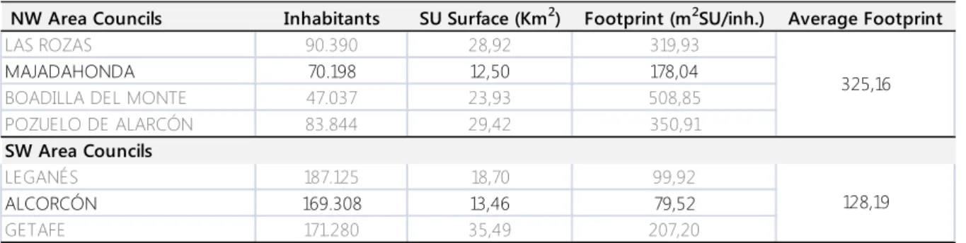
Table 2. “Unitary urban footprint” in the year 2011, for each municipality and overage for NW and SW sectors of the metropolitan crown of Madrid.
Urban dispersion:
The choice of the cases of study in this research seems to be so appropriate in order to merge at a same point. The values of urban dispersion for Majadahonda (178 m2/ inhabitant) and urban compactness for Alcorcon (79.5) in relation with the average in both sectors, NW (325 m2/inhabitant) and SW (128), might support this idea. Additionally, the current tendency suggests that the denser settlements develop the higher urban footprint (in urban systems) otherwise, the less dense tend to decrease its urban footprint (suburban and peripheral system). Nevertheless, differences are still so large between both urban systems.
In terms of housing, Alcorcon reflects 249.5 m2/dwelling unlike Majadahonda with 626. This contrast would reside in home composition (an average of 3.1 and 3.5 persons per house respectively) and acquires more significant importance with the value of average density of SU for each case: 29 dwellings/hectare in Majadahonda and 71 in Alcorcón.
Urban fragmentation:
It becomes very interesting the possibility of measuring the degree of urban fragmentation of the territory identified previously as dispersed and obtaining conclusions as a result of its comparison with a more compact one, especially if we have into account references to several parameters such as ecological sustainability, landscape or socioeconomic aspects.
The coefficient of fragmentation ranges from “1” (very fragmented) to “0” (non-fragmented). In Majadahonda this coefficient is 0.5 while in Alcorcón is 0.16. The urban fragmentation index can be obtained by multiplying by 100 those coefficients, resulting in 50% and 16% respectively.
NW Area Councils Inhabitants SU Surface (Km2) Footprint (m2SU/inh.) Average Footprint
LAS ROZAS 90.390 28,92 319,93
MAJADAHONDA 70.198 12,50 178,04
BOADILLA DEL MONTE 47.037 23,93 508,85
POZUELO DE ALARCÓN 83.844 29,42 350,91
SW Area Councils
LEGANÉS 187.125 18,70 99,92
ALCORCÓN 169.308 13,46 79,52
GETAFE 171.280 35,49 207,20
325,16
6 To get a simple outline of this difference, while in Majadahonda the hinterland town roads which link 10 fragmented settlements represents 19.95 km, in Alcorcon there are only 12.55 km linking 2 accidentally isolated settlements.
Image 4. Identification of the 10 sprawl cores in the hinterland of Majadahonda (adjacent to the center of the city can be identified 4 in the North and 2 in the South East, the last 4 are isolated and spread over the
municipality area). Image 5. Occupation, measured in kilometres, of highways and motorways in Majadahonda. It shows too the measure for local roads taken into account for connecting the cores of sprawl inside the municipality borders.
E. Land articulation: an unbalanced investment per capita in the road system
In terms of length of local roads (highways and split roads), the results obtained for the two cases of study shows 18.98 km in Majadahonda and 22.93 km in Alcorcon. This suggests a value for the proposed indicator of 0.00027 km/inhabitant in Majadahonda versus 0.000135 km/inhabitant in Alcorcon. This difference becomes higher if we take into account the nearly 20 km of local roads for connecting the diverse fragmented cores inside the administrative boundaries of Majadahonda.
4. CONCLUSSIONS
• The index which relates land consumption and urban densities (m2/inhabitant), that is
2.24 times higher in Majadahonda than in Alcorcon, does not represent any values to enable the establishment of parameters for defining the social dimension of the towns analyzed, but enables us to clearly identify an unsustainable and unavailable pattern of urban growth, at this moment.
• The population absorption capacity is 0.38 in a dispersed urban fabric compared to a
compact one, in the cases of Majadahonda and Alcorcon respectively. Therefore, the same consumption of ecological resources implies a higher impact over the territory and the urban economy, supporting much less population. In this way, it is a matter of low moderate densities versus high densities.
• Landscape impact, in terms of degree of urban fragmentation, is 3 times higher in
Majadahonda than in Alcorcon, due to the excess of isolated peripheral urbanizations which spread over the territory disrupting ecological corridors and dividing natural areas.
• Road infrastructure investment matches with land consumption, but differences are
7 these infrastructures: 2 times higher in Majadahonda than in Alcorcon. A dispersed urban model, based in a massive car use, implies an additional economic impact due to a higher infrastructure investment that generates a budget imbalance per inhabitant and a lack of social justice for the local citizens regarding the compact one.
• The dispersed and fragmented urban model of Majadahonda, connected with several
speed corridors, must be re-formulated. An improvement in the uses, activities and densities (which will provide a higher presence), would allow a better interaction among local citizens with a fewer impact over the landscape and the socioeconomic local policy.
Future lines of research an open path:
The parameters obtained after the empirical analysis suggest interesting patterns of urban, ecological, and socioeconomic procedures for specific urban extension models. It is necessary to develop an analytical tool for the evaluation and comparison of the diverse factors which drive urban density and form, with the goal of foreseeing events and helping in a better urban planning towards physical and political aspects, always in a long-term vision. What has happened with the land occupation model in the region of Madrid? What had been the most influential elements from the last decades? What are the estrategic target for the current land policy of polynucleated specialization and the subsequent high-investment in linking
infrastructures? It is necessary to focus the problem and use the adequate analytical tools in order to obtain a full panorama of the recent urban expansion in relation with the
sustainability triangle.
REFERENCES:
Fariña, J. y Pozueta, J. (1997) Mobility in the residential fabrics of the scattered suburbs. Universidad Politécnica de Madrid. Departamento de Urbanismo y Ordenación del Territorio. Gutiérrez Puebla, J. y García Palomares, J.C. (2007) Espacios residenciales en la ciudad dispersa. Homenaje al Profesor Casas Torres, 445-456. La ciudad dispersa: cambios recientes en los espacios residenciales de la Comunidad de Madrid. Universidad Complutense de Madrid. Departamento de Geografía Humana.
Hayden, D. (2003) Building Suburbia: Green Fields and Urban Sprawl. New York. Pantheon Books.
Inostroza, L. (2012) Urban Sprawl and Fragmentation in Latin America: A Comparison with European Cities. The Myth of the Diffuse Latin American City. Cambridge, MA. Lincoln Institute of Land Policy.
López de Lucio, R. (1993) De la ciudad fragmentada y compacta a la disgregación espacial articulada. Universitat de Valencia. Servei de Publicacions.
Muxí Martínez, Zaida (2013) Postsuburbia. Barcelona. Comanegra.
8 Ruiz, J. (2000) Planeamiento urbano territorial en Madrid. La experiencia reciente. Urban 5(14): 122-142. Universidad Politécnica de Madrid. Departamento de Urbanismo y Ordenación del Territorio.
Santiago, E. De (2008) Madrid 'ciudad única' (II). La explosión urbana en la región madrileña y sus efectos colaterales. Urban 13(14): 138-164. Universidad Politécnica de Madrid.