Procedia Chemistry 8 ( 2013 ) 328 – 336
1876-6196 © 2013 The Authors. Published by Elsevier B.V.
Selection and peer-review under responsibility of the IA-CS (Italian Association of Conservation Scientists) and University of Antwerp doi: 10.1016/j.proche.2013.03.040
Youth in Conservation of Cultural Heritage, YOCOCU 2012
Tiermes Cultural Lab: Excavation, conservation and musealization
of the archaeological site of Tiermes (Soria, Spain)
Pablo Arribas Lobo
a, Sagrario Fernández
b, Carlos Rodríguez
c, Flavia Zelli
d.*
aArchaeology Unit, IEUniversity of Segovia, Spainb-dDepartment of Theory and Architectural Projects, UVA University of Valladolid, Spain
Abstract
The intent of this paper is to explain the excavation, the renovation and the valorization intervention of the forum complex in the archeological area of Tiermes, located in the south east of Soria province (Spain).
This intervention has been made by a multidisciplinary expert group as part of the project "Tiermes: Cultural Lab", whose activity, after the problems diagnosis, has consisted in an intervention of consolidation and protection of the ruins, as well as an architectonic project to improving the accessibility and the integration of the archeological remains with the uniqueness of Tiermes landscape.
© 2012 The Authors. Published by Elsevier B.V.
Selection and peer-review under responsibility of IA-CS (Italian Association of Conservation Scientists)
Keywords: Tiermes; Architecture; Archeology; Heritage; Landscape.
1.Introduction
With this work we present an exhibition of the work carried out on the set and environment Forum Tiermes archaeological site, located in the southwest of the province of Soria, between the months of June 2007 and June 2010.
The commissioning of this work was carried out by the General Directorate of Heritage and Cultural Heritage of the Junta de Castilla y Leon, and has been endorsed by a multidisciplinary team from the University of Valladolid and IE University Segovia articulated in the Plan PAHIS through the initiative "Tiermes: Cultural
* Corresponding author. Tel.: +34 983 423 457. E-mail address: [email protected].
© 2013 The Authors. Published by Elsevier B.V.
Selection and peer-review under responsibility of the IA-CS (Italian Association of Conservation Scientists) and University of Antwerp Open access under CC BY-NC-ND license.
Lab", a slogan that defined the strategy for action on a Cultural Landscape of extreme singularity, the result of the interaction of different natural agents and human hand itself, which in this enclave has taken the soft sandstone which forms the matrix of the hill as the basis for public or domestic buildings.
Since 2007 when this project began, its activity can be grouped into different phases, including emergency works of consolidation and restoration, museological and enhancement works, be reconciled each with an integrated program of research, consolidation and restoration works.
2.Works of consolidation and restoration
This early intervention aimed at alleviating the deteriorating situation that threatened the ruins of the forum of the Roman city, began in the spring of 2007 after an initial evaluation and diagnosis-oriented analysis of the problems affecting the surface, restore object covered by a very poor geotextile mesh, under which there could be observed many of the pathologies afflicting the underlying structures: uncontrolled growth of vegetation, water accumulation, brick walls collapsed or at risk of collapse, etc.
Having identified the main problems in this area, works are grouped into four groups based on the type of intervention: consolidation, restoration, protection and water drainage, respecting strict criteria of reversibility, identification and constructive support, to allow non-aggressive removal of the added elements if deemed necessary, and the distinction between the original ruin and the reconstructed one by using parts, separating elements or materials that could clearly be distinguished [1] [2].
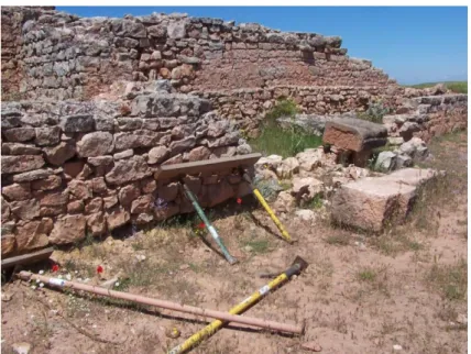
Fig. 1. Archaeological site, previous state. Collapsed walls, uncontrolled growth of vegetation and obsolete fastening elements.
2.1.Consolidation
construction
(
sottosquadro
)
covered with a plastering mortar of lime, sand and red earth, of a hue similar to the existing wall.Due to the neglect and lack of support some of the walls appeared collapsed, so we took the next step by relocating them; relocation received by mortar of lime, sand and red earth. Also, by concrete backings made with similar technique, there has been underpinning of structures that due to the effect of water runoff or over-excavation had lost some of their original medium. These measures have allowed the removal of obsolete fastening elements, including props that were no longer working and also the felling that carried by steel profiles unloaded, on shaky ground, the east wall of the Forum.
Also, we have proceeded to re-grow with a row of sacrifice all those walls that needed a guarantee of protection and contributing to facilitate the reading of the architectural spaces that they define. This was performed with identical characteristics of the existing construction: concerted masonry received with red and lime sand mortar, always separating the intervention provided by interposing a mesh between the original wall and the new.
2.2.Restoration
The presence in the north of the Forum of a space functioning as a tanker kept part of its opus signinum
coating in a state of serious deterioration, demanding a restoration intervention, carried out under the supervision of Numantino Museum´s Restoration Service. Moreover, its provisional protection covering the passenger compartment was eliminated, in order to proceed with its substitution by a more stable one, made of treated wood and copper coat, which rests on four small lime concrete footings. Thus a cabin was achieved, where all the restore process takes place, ensuring the same way conservation later on.
2.3.Protection
Those parts of the deposit which due to their weathering fragility could not be left outdoors, have been covered, once documented, with unused soil from older excavations, always on geotextile membrane, after filling in the case of drainage that would have required renewal of water under the fillings. In the cases where the imprint of a design element useful in reading the whole was hidden under the padding, we proceeded to recovery by placing similar parts made with different material, to make them identifiable: thus, in small elements´ cases they have been made with mortar as specified, and in the case of large building blocks with stone filled gabions, which guarantee its complete reversibility.
2.4.Water drainage
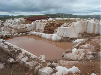
Fig. 2. Archaeological site, previous state. Water accumulation on the geotextile mesh and obsolete protections.
3.The archaeological works
Due to the status of the site declared a Cultural Interest Site since 1999, the archaeological activity has consistently been present since the beginning of the works, and through monitoring or controlling of these, or in its last phase with the excavation of the street and taverns located south of the terrace of the Forum, complex constituted by a great artificial platform, that embraces the slope of the hillside on which it is located, subject to different interpretations over its historiography, where it appears as Celtiberian or Roman fortress, or until recently as water reservoir and distributor.
The first of these activities has allowed the register, using the archaeological methodology, of all actions related to the needs of the consolidation project that have involved some kind of earth movement, allowing the recovery of a large batch of archaeological materials, including a wide variety of ceramic types, building materials, iron and bronze items, bone industry and fragments of mural paintings. Prominent among these the presence of a fragment corresponding to a hand sculpture made of white marble, broken at the height of the wrist and belonging to a monumental sculpture, probably related to the iconographic program of the Forum [3].
Meanwhile, the excavation during two campaigns in the area located south of the Forum has been effected for the purpose of providing the archaeological site of a unit that facilitates the understanding of the visitor after completing the work of recovery, exposing the street and the group of taverns located in the southern gallery of this complex [4] [5].
Its floor has been dug up on the hill of sandstone, which forms the floor of the streets and taverns to its eastern end, where the natural fall of the land make a leveling layer and the execution of a stronger foundation for the southeast corner and the first pillars of the gallery necessary, unlike most westerners who rely directly on graves excavated in the rock. All of them are of quadrangular section, and have a base constituted by a large block of tuff on which it rests, in cases that it has been preserved, a first row of the same type blocks followed by sandstone.
collected, among other materials, a complete profile of roman painted pottery, fragments of an amphora and a knife.
Other recesses made in the rock floor, possibly intended to support wood structures, are located in the street and inside the taverns. These, with dimensions of about 5 x 3 m, have more elongated proportions than the taverns from eastern gallery, and like those, they have retained their thresholds, consisting of large blocks of limestone with the groove and notches for the locking system.
The recovery of different building elements during excavation, such as arcade parts decorated with half columns, or the remains of stucco overlying, has allowed a first approach to the elevation of this complex, whose construction can be estimated, based on material provided in their levels of foundation (gallic roman pottery and numismatics) between the late Emperor Claudius and early Flavian period [6]. Other pieces, like the polished axe located next to the door of one of the premises, and whose presence we explain through its apotropaic function, allow us to approach the world of Roman ideology.
Meanwhile, among all of the archaeological material recovered at the landfill which filled the gallery, stands a rich batch of late Hispanic pottery and variety of coins and metal elements, among which are included the staple of lead for holding a statue or other related to the martial activity and horse riding. Also singular pieces have been
It is necessary to also mention the presence of reforms recorded in some of these taverns from the second half of the fourth century A. D., and how from this moment an urban decay process, is shown by the construction material and metal stockpiles documented within the gallery, as witnessed by the discovery in 2008 of a major batch of bronze, mostly corresponding to a robed statue, intentionally fragmented, perhaps like preparation for its melt [7].
In this way, the information provided by this intervention has served to enhance the data that we had about the core area of the city of Termes, adding a new space for the recovery project and encouraging the keeping, disclosure and thus, their heritage.
4.Musealization and enhancement
4.1.The landscape of the forum
Once established and recovered the archaeological site, as we proceeded with the excavations in the southern area during the summer of 2009 an architectural project that would meet 2 objectives was needed:
a) Make visible and understandable the ruins of the Forum as the central structure of the city, improving as far as possible the feasibility and accessibility to the public.
b) Contextualize and extend the value of the Forum archaeological remains within the overall structure of the site and so unique landscape of Tiermes.
Hence arises the conception of the whole Forum as a landscape understood in its full extent, including location, space, elements, interventions, tours, and with particular emphasis on building a sensitivity that allows a new way of seeing and understanding the ruins as fragments of history in a landscape.
The Landscape design greatly expands the meaning of the Forum within the site and forwards the intentions that are to be developed in the future. By this view, the meaning of the site in general, and the forum, in particular, is greatly expanded, not only from an intellectual and heritage view, but above all, from the understanding of the visitor, to which a multitude of mechanisms and values that give greater prominence to the visit are offered.
In this way, an enclosure that includes both the archaeological and all necessary supporting infrastructures for its enhancement, is defined. Parking is remodeled to provide an image along with the rest of the intervention, which raises an access area, with new signage, as input to the Forum area but also with the launch condition of visiting the site itself. In this way the visitor is introduced into the landscape of the site from the landscape of the Forum.
4.2.The idea of enclosure
The uniqueness of the Forum within the overall structure of the site necessitates the creation of a concept of enclosure that extends the geometric condition that the set introduced in the landscape of Tiermes. This defines a rectangular area with paths that depart from the actual design of the Forum. This enclosure also allows the definition of a tour organized for the visitors, who can see and understand the architectural establishment in the landscape of the hill on which they are situated.
One idea that Tiermes Cultural Laboratory aims to launch is the sustainability of the site. For this reason, part of the material used in the emergency of 2007-2008 is recycled for the definition of the new Forum part: the protective elements of the work (support consisting of concrete, metal post and rope) are reused and placed under geometry as described above. This mechanism is achieved by orienting the visit and defining an area that must be traversed by following the instructions of the guides of the site.
Fig. 3. Joint Forum, reformed state. The consolidation of the north area, with a new protection for the opus signinum tank, made of wood and copper coat. Behind, the wooden bridge.
4.3.Tours and facility visits
The tour starts on the ramp that provides access to the Forum from the Prairie Chapel, at that point a wall built with concerted masonry stone from the waste reservoir, with a sign in bronze with the word Tiermes. From there the visitor crosses the edge of the enclosure, using the definition described above; at different points along the way appear, strategically, concrete benches so that visitors can sit.
During the emergency, a provisional viewpoint, which is now reformed to adapt its position and profile to the site, was built; taking advantage of surplus land and also articulating the way. From the top of the lookout, the site as a whole is contemplated, from a privileged position, taking the view even beyond, to dominate the rest of the landscape.
In the highest part of the route lies a wooden platform as an observation and explanation point. From there, a wooden walkway of 1,50 m. wide starts, that browses the top of the forum without having to enter the wall remains. From the platform both a global and detailed view of the site are available. The gateway is constructed on uprights with concrete substrate, performed in situ and directly supported on the ground, without the need for footings or trenches. At the end of the gangway ladder, also made of wood, allows us to descend again to continue the visit along the sides of the Forum on the east side of the taverns below.
The tour continues through a paved road with rammed earth on the east and south side of those taverns: a platform in the corner becomes a point from which to look at the structure of the Forum or the landscape. The trail continues climbing through a new wooden staircase to the upper area of the taverns, where a path marked on the ground allows access to the highest point of any intervention, indicated with a new wooden platform from which a new path allows convenient access to the house of the Aqueduct to continue the visit.
We propose an alternative route that crosses the outside of the forum coming to the east of the tavern below, and another running from the south side of the taverns directly to the House of the Aqueduct, to avoid the use of ladders and facilitate the most of a visit to the set.
Fig. 4. Joint Forum, reformed state. Landscape view from the north stair. Streets and taverns after the restoration.
4.4.The elements of the project
To achieve the above purposes the project incorporates a number of elements already mentioned, which provide the whole of the Forum of the consistency needed to be traveled and understood:
a) Access: The entrance to the set is solved by a ramp that takes advantage of the natural slope to create the beginning of a journey, slightly ascending, complete with a side wall of concerted stone masonry, topped with the bronze letters mentioned above. The ramp is performed on packed earth with wooden planks and perimeter drains.
vision and understanding of the complex. A protective railing and stairs, also made in wood structure, to descend to the taverns of the East are included.
Its construction system uses wooden pillars formed by two planks of 7,5 x 20 cm plugs, interconnected by wooden beams consisting of wooden planks of the same dimensions, and small plank non-slip floor grooving with blunt edge, 5 x 15 cm. All the wood used is national, dried and autoclaved pine.
c) Platforms: In three points of the Forum (home gateway, corner taverns and lower connection to the new road to the Aqueduct ) paths are built using wooden platforms that allow visitors to locate and that contain information signals. Its construction is similar to that of the gateway.
d) Viewpoint land: During the emergency a small mound with soil from the excavation was formed provisionally, that is now relocated permanently to serve as a privileged point of observation of both the Landscape and Landscape Forum Reservoir. The viewpoint is solved by the earth on slopes, wooden shield, in form of steps made of wooden planks and wooden platform on top and with protective railing.
4.5.The marking of the forum
From the general access parking starts a signaling system of the complex, through "type signs" of different sizes. Within the precincts of the Forum, described above, these signaling elements are placed at various points, with particular emphasis on the act of looking. The marking serves different purposes: to guide, locate, inform, explain and teach how to observe, considering this observation at two levels: the historical reading (how the Forum was) and the current reading (how to be understood).
This signage also incorporates corresponding planimetric information, text and image reconstruction with hypotheses that help visitors to understand both the entire set as each of its singular parts. Four types of signs are used: type A, with an overview of the entire Board, Type B, with partial information of the Forum, Type C, with information about the details or sectors, Type D, indicating the points at which visitors must stop and watch. Thus, the signal broadens and emphasizes the philosophy of the project.
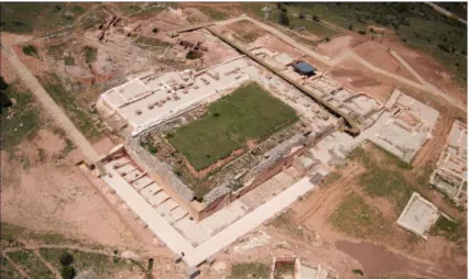
Fig. 6. Joint Forum, reformed state. Aerial view from southeast.
4.6.Typological and comparative analysis of the discovered structures
archaeological documentation and the keys of the architectural project are used as a method of analysis, which will help us understand and explain the final architectural result, simulating situations of design.
References
[1] Iglesia Santamaría, MÁ. Trabajos de consolidación, restauración del yacimiento arqueológico de Tiermes. Oppidum, 4. Segovia; 2009, p. 35-48.
[2] Álvarez D, Iglesia MÁ, González J, Zelli F, Fernández S, Rodríguez C, Santos P. Consolidación del Conjunto del Foro del Yacimiento Arqueológico de Tiermes. Montejo de Tiermes (Soria). VIII Premio de Arquitectura de Castilla y León, Actas. Valladolid; 2011, p. 116-119.
[3] Pérez González C, Illarregui Gómez E, Arribas Lobo P. Obras de consolidación en el yacimiento de Tiermes, 2007: Control Arqueológico. Oppidum 4. Segovia; 2009, p. 49-72.
[4] Pérez González C, Illarregui Gómez E, Arribas Lobo P. Excavación y control arqueológico en el foro de Tiermes. Intervención de 2008. Oppidum, 4. Segovia; 2009b, p. 73-98.
[5] Pérez González C, Illarregui Gómez E, Arribas Lobo P. Excavación arqueológica en la calle y tabernae meridionales del foro de Tiermes. Intervención de 2009. Oppidum, 5. Segovia; 2010, p. 79-112.
[6] Pérez González C, Illarregui Gómez E, Arribas Lobo P. Moneda y foro en Tiermes. Oppidum, 6-7. Segovia; 2011a, p. 61-84.