Emergency management in the highways of the future
A performance-based multilayered ITS architecture design proposal
Abstract—Emergency management is one of the key aspects
within the day-to-day operation procedures in a highway. Efficiency in the overall response in case of an incident is paramount in reducing the consequences of any incident. However, the approach of highway operators to the issue of incident management is still usually far from a systematic, standardized way. This paper attempts to address the issue and provide several hints on why this happens, and a proposal on how the situation could be overcome. An introduction to a performance based approach to a general system specification will be described, and then applied to a particular road emergency management task. A real testbed has been implemented to show the validity of the proposed approach. Ad-hoc sensors (one camera and one laser scanner) were efficiently deployed to acquire data, and advanced fusion techniques applied at the processing stage to reach the specific user requirements in terms of functionality, flexibility and accuracy.
Keywords- Highway, Emergency management, ITS architecture, Service Specification, Ad-hoc services, User requirements.
I. INTRODUCTION
There is an increasing trend in ITS-oriented communications to consider the user as the central piece of the design of the systems involved in a service or application making use of those communications. Of course, the users have always been the starting point of the specification of any service or system by means of service requirements and, more rarely, operational specifications of these services and applications. However, the system design choices resulting of these requirements, usually of a higher level of technological detail than the user's requirements, are often imposed on the users, rather than simply extracted from their needs.
This is particularly relevant in the case of emergency response systems for public safety, in which several responder groups, with different priorities and responsibilities, are commissioned to perform their corresponding tasks and rely mostly on their own established procedures, systems and technologies to accomplish those tasks. There is, however, a need to coordinate different teams, and the actuations of different emergency response groups must be integrated in a single protocol framework.
Invariably, a key aspect of the emergency protocols should be the acquisition of data about the incident in order to first activate the appropriate action chain and at a later stage, to support the taking of decisions, if necessary.
However, it is possible that due to the nature of the incident, and the environment and circumstances in which it takes place, part of the infrastructure that should have been used for data acquisition is partly or completely unavailable, either for the first assessment of the situation -to activate the corresponding protocol- or in the decision making within the protocol itself. In these cases, the deployment of ad-hoc resources for data acquisition or communications is necessary, but it is equally possible that even though available data sensor and communications infrastructure allows for a limited performance emergency response operation, improved performance and efficiency in this response can be achieved by the ad-hoc deployment of equipment which provides specifically additional data which allows the emergency services for a more accurate assessment of the emergency situation and its development intime.
The specification of the data necessary for this correct assessment of the emergency must come from the emergency teams themselves, and in fact, in several cases in which integrated emergency protocols have been established, minimum data specification and the required infrastructure for its acquisition have been provided by them.
However, some issues are still open. Is there any way to specify what exactly "necessary data" is? And once this data is defined, how its acquisition and processing in the most efficient way in relation to the users requirements should be specified? Finally, is there some way to specify the resources necessary to achieve these requirements? It can be argued that one of the reasons of the relative reluctance of the emergency teams to adopt new solutions to help them face these issues is the absence of a common way to specify requirements of complex systems, both in terms of system description as well as to how do define the performance of it from the user's point of view.
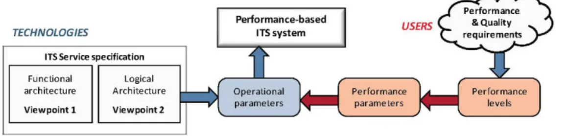
architecture. This mapping is based in the identification and specification of relevant performance levels from the user's point of view and the definition of a set of operational parameters which allow the univocal description of the performance levels in terms which can be subsequently easily imposed as operational requirements for simple devices and elements of such a complex system [2].
The whole methodology (Fig. 1) will be illustrated in this paper by means of a particular emergency response service example: a traffic incident emergency response in a highway, and in particular, a functionality which could be the Situation Analysis. We will focus on the importance of using sensors networks to acquire data, process it applying different technologies and transmit relevant information (E.g. image captures, videos, etc.) from the incident and the environment around for a better assessment from the distance of the situation.
II. HIGHWAY EMERGENCY RESPONSE SITUATION
ANALYSIS
One of the typical steps in highway operators' emergency protocols, the situation analysis is the stage of the procedure in which all possible data about the incident is gathered in order to engage the appropriate emergency response: which internal resources to use, which external entities to notify, if necessary, etc.
The information to be gathered in case of an accident in a highway is defined in the case of Spain, by means of highway operations emergency protocols, which in turn extend the corresponding applicable laws on the subject [3]. In general, this data may include the location, date and time of the accident, the number and vehicle of vehicles involved, the damage caused to vehicles and infrastructure, possible injured/deaths, and the general scenario characterization.
Usually, an emergency protocol takes a particular situation as the starting point of the emergency response procedure, but there is very little described on how the situation should be identified of how additional useful data should be acquired from a sensor point of view.
Throughout this paper, these issues will be addressed in the context of an emergency situation, namely a traffic accident in a highway, consequence of which part of the highway sensor infrastructure might have been damaged, and therefore an ad-hoc sensor deployment is necessary in order to obtain the data necessary for the proper assessment of the
situation. Further extending this view, a basic assessment of the potential links between the desired performance level of this functionality and the implications on the requirements to be imposed on its different sub-systems will be explored, with particular attention in the data acquisition sub-system.
III. THE "TRADITIONAL" SPECIFICATION OF AN IT S
ARCHITECTURE
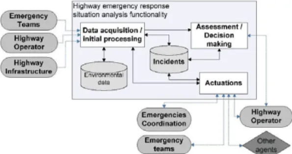
As with any complex system, the description of the chosen emergency response situation analysis functionality can be addressed in first instance by applying the usual steps in architectural description of the services. This approach has usually been based in a thorough description of applications/services, their requirements and functional breakdown (Table I) [1].
Viewpoint 1 is the key to any service specification in the sense that it provides the tools to describe uniformly the relevant high-level elements of the services and applications, such as the relevant functionalities, main actors and main data structures; storage, flows and internal and external interfaces. In the example developed in this paper (Fig. 2), the basic data required for the emergency protocols must be identified here, as well as the main steps of the emergency protocols as "data acquisition", "assessment/decision making" and actuations are concerned. The complete description of the service includes other functionalities, such as the external communications functionality, which would specify in further detail the data exchange with external agents, or the acquisition of environmental data, not directly related to the incident, but which can provide useful information for the assessment of the emergency.
However, the key to the performance-based description of the service is its Viewpoint 2 specification (Fig. 3). Viewpoint 2 is the logical and topological description of the service and its functionalities. Viewpoint 1 described the applications in terms of what should be done, while Viewpoint 2 makes a big approach to the question of how it should be done (which will be extended later by the methodology proposed in this paper to make it how to describe how well it should be done). As with Viewpoint 1, the complete description of the emergency response service will include additional functionalities, the combination of which can be seen as the application implementation and layout of a given emergency protocol in terms of logical elements.
TECHNOLOGIES
ITS Service specification
Functional architecture
Viewpoint 1
Logical Architecture
Viewpoint 2
n
Performance-based ITS system
Operational
parameters
fc
USERS
TABLE I. ARCHITECTURE VIEWPOINTS
Denomination Description
Viewpoint 1 Functional
The basic elements in Viewpoint 1 are the services to be offered by the road operators, described in this abstraction level by means of the main identified functionalities, actors, data storage and data flows.
Viewpoint 2 Application
The basic elements in Viewpoint 2 are logical components of the Viewpoint 1
functionalities, considering in particular input/output elements, processing elements, data storage elements and data
communication links, together with a first approach to topological distribution.
Viewpoint 3 Implementation
The basic elements of Viewpoint 3 are the particular technologies which will be used to fulfil the requirements specified by services and applications described in Viewpoint 1 and Viewpoint 2.
Finally, Viewpoint 3 must be the practical deployment of the necessary resources to ensure that the minimum service requirements established in Viewpoint 1 are met, following additionally the topological layout specified as adequate in Viewpoint 2. This practical view means that technological, rather than operational decisions must be taken, and choices must be made based on the knowledge that Viewpoint 1 and Viewpoint 2 provide about a given service.
From our point of view, the highways of the future should provide operators in the control centres with relevant pre-processed information coming from the network of sensors deployed in the infrastructure, both ad-hoc in case of emergency and those remaining fixed in a normal operational situation. On one hand, camera and LIDAR-based technologies have shown remarkable developments over recent years, reaching at the same time cost-effectiveness and reliability. Furthermore, multisensor data fusion has become a broadly demanded discipline to achieve advanced solutions that can be applied in many real world situations, allowing the overall classification accuracy improvement [5]. On the other hand, the use of nomadic devices (mobile phones, PDAs, etc.) for support and communication of other types of information that at the moment cannot be provided by sensors is becoming increasingly common.
IV. PERFORMANCE-BASED SERVICE SPECIFICATION
The main advantage of the proposed description of the logical architecture of the service would be that a given end-to-end service requirement can be more easily distributed on the different relevant elements, imposing particular requirements for the defined parameters of those elements or extending the defined parameters to include new specifications.
A typical example of end-to-end parameter is the latency of a service, which can be understood as the time elapsed between the occurrence of an incident and the reception by the user of the notification from the corresponding service. While in some services this delay might not be important, in other cases it is the key operational parameter of the service, as it happens in the case of emergency response services, for example. Knowing that a service should have a latency limit of 2 minutes, it is possible with the proposed scheme to distribute this latency in the different elements of the service, accurately and precisely specifying the maximum delay in different communication links, data retrieval processes, data filtering and processing and notification to the users.
The general methodology for extracting operational requirements for the previously identified logical elements is a procedure involving several stages:
1. Identification of relevant performance levels within the service/application/system. These can be seen as criticality levels from the point of view of the user, and correspond therefore with the user's high-level performance requirements.
The following levels can be identified: "Off-line information", "Real time information", "Warning", "Advise" and "Support/Intervention", corresponding to increasing levels of criticality and system intervention in the response [2].
In the case of this paper example service functionality, it must be assumed that the desired performance level is largely defined by the strictest requirements on the response of the system, plus be able to support the decision making process. Thus, according to this methodology, a performance level of "Advise" is selected for this functionality.
2. Identification of relevant performance parameters which allow the complete characterization of the different performance levels.
The second step involves the identification and specification of different value combinations of a set of parameters and indicators so that the performance level
Highway emergency response situation analysis functionality
Figure 2. Simplified Viewpoint 1 example service functionality specification
Highway emergency response situation analysis functionality
Road / Roadside Main Control Centre Fixed infrastructure
Ad-hoc deployment
Situation assessment
Local Ad-hoc Data Fusion
Decision making
Q B
Operator additional data-H Actuations
selected is univocally and completely characterized. Some relevant performance parameters identified are "legibility", "workload", "flexibility", "error management", "accuracy" and "latency" [2].
Therefore, considering the "Advise" performance level for the selected functionality, its possible description in terms of selected performance parameters could be that the required "accuracy" could be specified at 95%, "latency" could be established at a conservative maximum value of 1 second response time for the functionality, and we can finally assume an error intolerant approach to the data acquisition, processing and distribution within the functionality.
However, it is to be noted that in some cases this mapping of parameters into operational requirements is not as straightforward a task and remains still an open issue. What does "Accuracy" mean in terms of data which can involve well defined magnitudes such as distance, time, a discrete number of vehicles, but also degree of damage in a vehicle or status of the possible injured?
3. Mapping of performance values and logical elements. This can be seen as the crucial step of the methodology, in the sense that it represents the overlapping point of the detailed user's requirements in relation to the service provided and the description of the logical deployment of the service. In this step, a number of operational requirements
can be extracted from a general performance level need and afterwards mapped into identified logical elements of the service/application, as can be seen in Table II.
However, it is to be noted that this step might involve an iterative process in order to reach the results of the table. Following the example, the starting point is an initial Viewpoint 2 which may consider only which data to be acquired from the scene of the incident, but when the performance requirements in the previous point are defined (for example, the 95% accuracy), it is necessary to further detail these same logical elements to ensure the requirements are met. Several issues arise now that must be considered. In ideal circumstances, is the existing infrastructure enough to provide the required levels of performance? What happens if the incident happens at night? And finally, what happens if the incident makes part of the existing sensor infrastructure unavailable?
Providing answers to these questions is closely related to the following step: the selection of technologies and technological processes which comply with these operational requirements, thus ensuring that the overall performance level requirements will consequently be met. The result of this process would be the full Viewpoint 3 specification of the service/application, a small part of which will be presented in the next part of this paper.
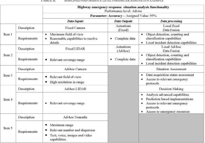
TABLE II. SIMPLIFIED PERFORMANCE LEVEL PARAMETER ASSIGNATION EXAMPLE
Item 1
Item 2
Item 3
Item 4
Item 5
Description
Requirements
Description
Requirements
Description
Requirements
Description
Requirements
Description
Requirements
Highway emergency response situation analysis functionality
Performance level: Advise
Parameter: Accuracy — Assigned Value: 9 5 %
Data Inputs
Fixed Camera
• Maximum field of view • Reasonable capabilities to resolve
details
Fixed LIDAR
• Relevant coverage range
Ad-hoc Camera
• Relevant field of view
• High resolution in range
Ad-hoc LIDAR
• Relevant coverage range
Ad-hoc Nomadic
• Maximum range
• Relevant number and dispersion
• Text, voice, images and video capabilities.
Data Outputs
Actuations (Fixed)
• Complete data
Actuations (Ad-hoc)
• Complete data
Data processing
Local fixed Data Fusion • Object detection, counting and
classification capabilities • Local incident detection capabilities
Local Ad-hoc Data Fusion • Object detection, counting and
classification capabilities • Local incident detection capabilities
Situation Assessment
• Data acquisition status assessment • Access to relevant emergency
protocols
Decision Making
• Analysis advanced capabilities • Prediction based implementations • Access to relevant emergency
protocols
V. DESIGN CHOICES
Some of the design choices can be made even without entering into particular application scenarios or technological issues. An incident might occur in a place where coverage by operator infrastructure is limited or nonexistent or has been affected by the incident itself. As requirements in relation to accuracy, for example, must still be met, the only solution is to deploy the necessary ad-hoc equipment to ensure this condition, either for the acquisition and processing of data, or in relation to the data communications devices. Thus, the second iteration of the step 3 must include the presence of ad-hoc logical elements, and more detailed operational requirements for this second "version" of the Viewpoint 2 can thus be extracted.
Traffic monitoring has specific requirements in terms of object detection and reliable identification of incidents in order to ensure safety of road users. In terms of flexibility to provide relevant information, cameras provide a lot of visual pre-processed data but are quite sensitive to illumination and weather changes. On the other hand, laser scanners offer robust and accurate distance information even in poor lighting conditions although they do not provide visual information that allow verifying the result of the detection. The integration and analysis of data coming from multiple sensors allows developing a more accurate understanding of a situation and determining how to respond to it. Thus, complemented with the appropriate processing capabilities, any ad-hoc system like the proposed in this paper could be used to provide information about the number and type of vehicles involved in the incident, and the particular characteristics of the scenario being monitored.
In case of emergency, nomadic devices can be used to send images of the vehicles involved in the traffic incident, the occupants and their surroundings, and their positioning to third parties. Once aware of the potential limitations and operational characteristics of the data input devices to be used, it is necessary to match the desired requirements in terms of the identified performance parameter values and the available resources for the emergency response. With relation to the flexibility of the system, this process will imply that the system will need to be aware of the time of the day, and in case the incident takes place during nighttime hours, for example, data from the cameras should not be weighted as heavily as data from other illumination-independent devices, but as the number of these might not be enough, higher level processing modules should be aware of this situation and consequently advise for the deployment of the necessary additional resources (in this case, ad-hoc LIDAR or nomadic devices). Just to point out another aspect related to the flexibility (and also accuracy), an incident involving a dangerous goods vehicle will require an additional deployment of resources in order to identify its cargo properly and being able to call for the appropriate emergency response groups. The system must be therefore able to recognize this situation, and after the accident has been detected and the presence of the dangerous goods vehicle confirmed, advise consequently as the next step to
deploy the necessary additional data input resources to gather the necessary information about the incident.
Some of these issues are included in the table of logical requirements for accuracy, as reaching a certain level of accuracy when counting vehicles involved in an accident, for example, will require a minimum number of data input devices, the number and type of which will depend on other factors such as the time of the day and damages to the sensor infrastructure itself, which in turn might make it necessary to deploy more devices. On the other hand, if there are more road users able to provide additional information through their nomadic devices, it could happen that the number of devices to be deployed as ad-hoc sensors can be reduced. It is certainly difficult to specify requirements based on this idea, and probably tools such as metrics for measurement of adaptation capabilities of a system, or development of advanced analysis and prediction algorithms will be necessary before the issue can be addressed in a proper way.
At a smaller scale, it is possible to address both flexibility capabilities and accuracy improvement by means of data fusion of different sensors. In the next part of the paper, it is going to be seen how the use of a camera and a LIDAR, both with their own strengths and weaknesses, can greatly widen the capabilities of the emergency detection system.
VI. MULTISENSOR DATA FUSION
As commented before, traffic monitoring applications have specific requirements in terms of object detection and reliable identification of incidents in order to ensure safety of road users. Thanks to the appropriate data fusion technique, we can give these systems the power to exploit automatically all relevant information from multiple sources to assess both daily supervision and emergency management operations.
We will focus on the application of data fusion to active vehicle monitoring in a particular area of high density traffic. By means of the combination of different computer vision, signal processing and machine learning techniques, the effectiveness of detection and tracking of objects is improved. Similarly to [5], our system proposes fusion of data at a feature level which is extracted from a video camera and a laser scanner contributing to detect accurately objects even under poor visual information. In addition, a set of logical and spatio-temporal constraints are applied on these features to make correct assessment on the situation or incident that may have happened.
A real experimental testbed in Madrid (Spain) has been implemented for the evaluation of the proposed architecture. Such scenario is a closed circuit where real traffic situations can be simulated, and where a firewire camera and a SICK LMS221 LIDAR have been ad-hoc deployed.
.J..
HOC
1 I
"
. i.fl
-j-j- :
1 *ji
¡ Í
Y |
* •• I f- Í
upon
3DJD
2500
2 [AD
1HQ
1000
500
•
;
fi
[t -
fi
J
•
•
t
t
X
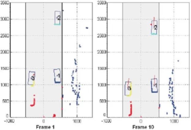
Figure 4. Visual results provided by processing laser scanners information in a traffic monitoring scenario, in which three vehicles are correctly detected and tracked along the sequence
reasons, no captures from the camera can be shown at these moments.
Finally, in the same way that humans are able to analyze both temporal and spatial relations among items in the scene to associate them a meaning, once the targets objects have been correctly detected and tracked, it is desired that machines can provide a trustworthy description of what is happening in the scene under surveillance in order to correctly assess the situation [6]. Accomplishing so ambitious task requires a machine learning-based hierarchic architecture like the one proposed in [5] able to extract and analyse behaviours at different abstraction levels in a traffic incident related scenario. By defining in advance what can be considered as incident, this processing step at high-level would complement the proposed system to provide the desired local incident detection capabilities.
V I I . CONCLUSIONS
There are of course some issues within the general methodology presented, arguably more evident when considering the emergency situations, in which resource deployments are usually made on a case-by-case basis and additionally, often under tight time constraints. One of the main issues is the reliance of the presented methodology on a thorough knowledge of the logical specification and layout of the applications, something that might not be possible with the kind of applications used in different, overlapping
emergency response protocols used in general emergencies. However, in the context of the highway emergencies, response protocols are usually quite detailed, including extensive specifications of resources and tasks to be performed in every case. The methodology presented in this paper can be seen as a potential additional value of these emergency protocols, in which performance issues have been addressed and matched with existing resources and the resources likely to be deployed in an emergency case to reach a minimum specification of the response application in order to meet the necessary or desired performance level.
Finally, to show the validity of the proposed approach, and taking the parameter accuracy as the reference for the study, a real experimental testbed has been implemented. One firewire camera and one LIDAR scanners have been ad-hoc deployed and some simulations have been carried out. In the processing stage, thanks to the appropriate multi-sensor data fusion technique, all relevant information is extracted from these sources and then combined to assess the emergency management supervision operation in case of a traffic incident.
ACKNOWLEDGMENT
Part of this work is being supported by the Spanish CENIT OASIS (CENIT-2008 1016) project [4], funded by CDTI (belonging to the Spanish Ministry of Science and Innovation).
REFERENCES
[1] R. Bossom, V. Avontuur, J.-F. Gaillet, G. Franco, P. Jesty, "European ITS Framework Arquitecture Overview", KAREN Framework Architecture Development Deliverable D3.6, 2000.
[2] J. Alfonso, J. Torres, J.M. Menéndez, "Towards a user goals-based multilayered ITS architecture", 8l European ITS Congress
Proceedings, Lyon, France, June 6-9, 2011.
[3] Directive 2004/54/EC of the European Parliament and of the Council on minimum safety requirements for tunnels in the Trans-European Road Network, April 2004.
[4] CENIT OASIS Project (CENIT-2008 1016): www.cenitoasis.com
[5] N. Sánchez, A. Cuerdo, D. Sastre, J. Alfonso, J.M. Menéndez, "Multisensor Data Fusion for Accurate Modelling of Mobile Objects", Information Systems Technology Panel Symposium on Emerged / Emerging "Disruptive" Technologies (NATO RTO IST-099/RSY-024, Madrid, Spain, May 9-10 2011.