Report on
1:100 000 Scale Geological and Metallogenic Maps
Sheet 3366-23
Province of San Luis
John P. Sims, Peter G. Stuart-Smith and Roger G. Skirrow
GEOSCIENTIFIC MAPPING OF THE SIERRAS PAMPEANAS ARGENTINE-AUSTRALIAN COOPERATIVE PROJECT
AUSTRALIAN GEOLOGICAL SURVEY ORGANISATION
CONTENTS
Page
SECTION I: GEOLOGY ... 1
1. INTRODUCTION ... 1
1.1 Location and access ... 1
1.2 Nature of work ... 1
1.3 Previous investigations... 4
2. STRATIGRAPHY ... 5
2.1 General Relations ... 5
2.2 Palaeozoic Metamorphic Basement ... 7
2.2.1 Introduction ... 7
2.2.2 Cambrian ... 7
Conlara Metamorphic Complex ... 7
2.2.3 Devonian ... 10
Las Lajas Shear Zone ... 10
2.3 Palaeozoic Igneous Rocks ... 12
2.3.1 Ordovician Intrusives ... 12
Undifferentiated granitoids and pegmatites ... 12
2.3.2 Devonian Intrusives ... 13
San José del Morro Granite ... 13
Achiras Igneous Complex... 14
2.3.3 Minor Dyke rocks ... 16
2.4. Tertiary volcanics ... 17
San Luis Volcanic Group ... 17
2.5 Cainozoic ... 19
Unconsolidated cover ... 19
2.6 Quarternary ... 20
Unconsolidated deposits ... 20
3. TECTONICS ... 21
3.1 Pampean Cycle ... 21
3.2 Famatinian Cycle ... 23
3.3 Achalian Cycle ... 24
3.4 Andean Cycle ... 27
4. GEOMORPHOLOGY ... 28
5. GEOLOGICAL HISTORY ... 29
5.1 Early Cambrian sedimentation ... 29
5.2 Pampean Cycle ... 30
5.3 Early Palaeozoic turbidite sedimentation ... 30
5.4 Famatinian Cycle ... 30
5.5 Achalian Cycle ... 31
5.6 Carboniferous - Permian sedimentation ... 32
5.7 Mesozoic sedimentation and magmatism ... 33
SECTION II: ECONOMIC GEOLOGY ... 34
1. INTRODUCTION ... 34
2. METALLIC MINERAL OCCURRENCES ... 36
2.1 W deposits of the sierras de Los Morillos, Morro and Yulto ... 36
2.2 Pegmatite-related deposits of Be, Li ... 40
3. NON-METALLIC MINERAL OCCURRENCES ... 42
3.1 Mica, quartz, feldspar ... 42
BIBLIOGRAPHY ... 43
SECTION I: GEOLOGY
by John P. Sims and Peter G. Stuart-Smith
1.
INTRODUCTION
1.1 LOCATION AND ACCESS
The 3366-23 map area forms an east-west transect within San Luis and Córdoba Provinces; ~46km by 40km between latitude 33°00’-33°20’ S and longitude 65°00’-65°30’ W. The area includes parts of two 1:250 000 scale map sheets: 3366-IV (unnamed), and Sierras de San Luis y Comechingones.
The area covers Sierra del Morro, Sierra del Portezuelo, southern Sierra de Comechingones and eastern Sierra del Yulto, and includes the minor population centres of La Punilla, La Esquina, and San José del Morro. The area is traversed by national route 148 and
provincial routes 1, 10, 13, 22A and 25A. The main drainage is via numerous minor creeks including Arroyo los Pozos, Arroya la Aguada and Arroya La Guardia.
1.2 NATURE OF WORK
The mapping of the sierras de San Luis and Comechingones was carried out in 1995 and 1996 under the Geoscientific Mapping of the Sierras Pampeanas Argentina - Australia Cooperative Project by geologists from the Australian Geological Survey Organisation and the Subsecretaría de Minería, Argentina. The mapping employed a multidisciplinary approach using newly acquired high-resolution airborne magnetic and gamma-ray spectrometric data, Landsat TM imagery, and 1:20 000 scale (approximate) black and white air photography. All geological maps were compiled on either published 1:20 000 scale topographic maps where available, or topographic bases produced at photo-scale from rectified Landsat images controlled by field GPS sites.
was derived from the digital terrane model (DTM).
1.3 PREVIOUS INVESTIGATIONS
Previous regional geological mapping was at a scale of 1:200 000 includes investigations by Pastore and Gonzalez (1954) of San Francisco (Hoja 23g), Pastore and Huidobro (1952) of Saladillo (Hoja 24g), and Sosic (1964) of Sierra del Morro (Hoja 24h).
More recent geological investigations have been of greater detail and have concentrated on the stratigraphy (e.g. Prozzi and Ramos, 1988; Ortiz Suárez and others, 1992) , regional structure (e.g. González Bonorino, 1961; Criado Roqué and others, 1981; von Gosen and Prozzi, 1996), the complex igneous intrusive history (e.g. Zardini, 1966; Brogioni and Ribot, 1994; Llambías and others, 1996a, b; Sato and others, 1996; Otamendi and others, 1996; Pinotti and others, 1996), Tertiary volcanism (e.g. Brogioni, 1987, 1988; 1990), and extensive studies on the numerous mineral deposits (e.g. Sabalúa and others, 1981;
2.
STRATIGRAPHY
2.1 GENERAL RELATIONS
The Sierras Pampeanas are a distinct morphotectonic province of early- to mid-Palaeozoic metamorphic, felsic and mafic rocks that form a series of block-tilted, north-south oriented ranges separated by intermontane basins. These ranges are bounded by escarpments developed on moderate to steeply dipping reverse faults developed during the Cainozoic Andean uplift (Jordan and Allmendinger, 1986).
Recent geological and geophysical surveys conducted during the Cooperative Argentine-Australia Project in the Sierras Pampeanas show that the Paleozoic basement of the southern Sierras Pampeanas contains of a number of distinct lithological, structural and metamorphic domains separated by major tectonic zones. There are two principal domains: an older, Cambrian domain, and a slightly younger, Ordovician domain. Both domains share a common geological history since early Devonian times.
Rocks of the Cambrian domain in the 3366-23 consist of the Conlara Metamorphic Complex. The Ordovician domain is not represented on this sheet, however, a number of Ordovician granitoids intrude the Cambrian basement. Additionally, the Cambrian
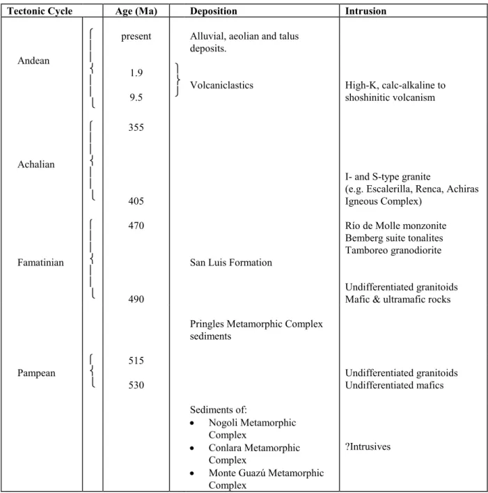
Table 1. Summary of the stratigraphy and age relations of the Sierras de San Luis y Comechingones (Sims and others, 1997). Age data and discussion of the various tectonic cycles are presented within the text. Some units are not represented on 3366-23.
Tectonic Cycle Age (Ma) Deposition Intrusion
Andean present 1.9 9.5
Alluvial, aeolian and talus deposits.
Volcaniclastics High-K, calc-alkaline to shoshinitic volcanism Achalian 355 405
I- and S-type granite
(e.g. Escalerilla, Renca, Achiras Igneous Complex) Famatinian 470 490
San Luis Formation
Río de Molle monzonite Bemberg suite tonalites Tamboreo granodiorite
Undifferentiated granitoids Mafic & ultramafic rocks
Pringles Metamorphic Complex sediments Pampean 515 530 Undifferentiated granitoids Undifferentiated mafics
Sediments of:
Nogoli Metamorphic Complex
Conlara Metamorphic Complex
Monte Guazú Metamorphic Complex
2.2 PALAEOZOIC METAMORPHIC BASEMENT
2.2.1 INTRODUCTION
The metamorphic basement of the 3366-23 consists almost entirely of rocks of at least Cambrian age (Conlara Metamorphic Complex) that were deformed and metamorphosed during the late Cambrian, Pampean Tectonic-Cycle. A minor subdivision of the basement rocks is represented by the Las Lajas Shear Zone that formed during the Achalian Tectonic Cycle in the Devonian.
2.2.2 CAMBRIAN
Conlara Metamorphic Complex ( –Ccgn, –Cce)
Pelitic and psammitic schist and gneiss; orthogneiss, minor calc-silicate and marble; pegmatite.
The Conlara Metamorphic Complex, comprises the majority of the basement outcropping within the valley (Valle del río de Conlara) between the Sierras de San Luis and Sierra de Comechingones. The Conlara Metamorphic Complex also incorporates the metamorphic part (the “Metamorfitas y Anatexítas India Muerta”) of a previously defined metamorphic-intrusive complex, the Achiras Complex (Otamendi and others, 1996), in the extreme south of the Sierra de Comechingones. The igneous part of the Achiras Complex of Otamendi and others (1996) has been redefined as the Achiras Igneous Complex.
The Conlara Metamorphic Complex comprises dominantly late Neoproterozoic - early Cambrian sediments intruded by Cambrian and/or early Ordovician granite and
polymetamorphosed in the early-mid Palaeozoic. The thickness of the sedimentary sequence is unknown due to the generally shallow orientation of the main transposition foliation. The Complex is intruded by a series of Devonian granites, which post-date the dominant structural and metamorphic episodes, and by Neogene calc-alkaline to shoshinitic volcanism. The Complex has a generally low magnetic signature and may be separated into regions that are comprised dominantly of gneiss, and areas comprised dominantly of schist.
Metapelitic and metapsammitic quartz-feldspar-biotite-muscovite-garnet-sillimanite ±tourmaline±chlorite schist is the most abundant rock type in the Conlara Metamorphic Complex (approximately 50%). The schist contains a well-developed biotite-muscovite foliation that is openly folded at a meso- to macro-scopic scale with long, generally shallowly east-dipping limbs and short, shallowly west-dipping limbs. Strongly corroded sillimanite, biotite coronas on garnet, and coarse poikiloblasts of muscovite and quartz containing tightly crenulated inclusions of sillimanite, suggest that the dominant fabric is a low temperature overprint of an earlier higher-grade (amphibolite-facies) fabric. Biotite and muscovite define a generally east plunging mineral lineation while shear-sense indicators are well developed and show a dominantly east-up displacement that is
consistent with the asymmetry of folding. An east-down shear-sense is locally preserved, however, particularly close to the western margin of the complex and where this fabric is associated with migmatitic shear bands and extensive pegmatites.
In places, the schist contains a metamorphic differentiated layering that consists of
alternating leucosome and millimetre-scale quartz-rich layers, and in the southern Sierra de Comechingones, contains minor interlayered tonalitic gneiss and banded ortho- and para-amphibolite. Within a kilometre of the Las Lajas Shear Zone in the southern Sierra de Comechingones, the schists are mylonitic and boudinaged, and chloritic alteration of biotite is common.
Metapelitic and metapsammitic quartz-feldspar-biotite±garnet±sillimanite gneiss is the next most abundant unit within the Conlara Metamorphic Complex (~40%). It is clearly distinguished from the schist by the paucity of muscovite in the foliation, and more
massive outcrop style. Where secondary muscovite is developed, it is generally unoriented and a minor component of the mineral assemblage, or it is associated with discrete
veins are common in this rock type and typically define the main foliation, which is tightly to isoclinally folded (and refolded) at a meso- to micro-scopic scale.
Felsic orthogneiss is interlayered with both the gneiss and schist and constitutes a relatively minor component of the Complex. The orthogneiss is strongly foliated and consists
dominantly of equigranular quartz, feldspar and biotite with minor muscovite. The foliation in the orthogneiss appears to be contiguous with the earliest fabric in the
enclosing rocks and suggests that the original granite was emplaced during either the early Cambrian Pampean orogeny or Cambro-Ordorvician Famatinian orogeny.
Calc-silicate and marble are intimately associated and are a minor constituent of the complex, they are restricted to a series of narrow layers and pods through Sierra de Yulto, Sierra Los Morillos, Sierra del Morro and Sierra de la Estenzuela. Marble is subordinate and is predominantly calcite with minor quartz and diopside, while the calc-silicate assemblage includes hornblende, plagioclase, garnet, sphene, calcite and magnetite, with thin diopside coronas locally developed on garnet. Additionally, secondary veins crosscut the marble and calc-silicate and are associated with tungsten mineralisation, these include wollastonite-flourite-scheelite veins in Sierra los Morillos, and pegmatitic epidote-feldspar-amphibole-biotite-pyrite-calcite-magnetite-quartz veins in Sierra de Yulto. The magnetic susceptibility of the marble is generally low (<36 x 10-5 SI) while the calc-silicate produced
values up to 1231 (x 10-5) SI, and the late pegmatitic veins produced local values up to
3512 (x 10-5) SI.
Various generations of quartz-feldspar-biotite±muscovite±tourmaline±garnet pegmatite also occur within the Conlara Metamorphic Complex. Early generations are strongly deformed and are elongate and boudinaged in the schist and gneiss. Later generations are somewhat less deformed and are spatially associated with Devonian granites. The
2.2.3 DEVONIAN
Las Lajas Shear Zone (Dlmi)
Mylonitic schist, granite, marble, orthoamphibolite, pegmatite and serpentinite
The Las Lajas Shear Zone is a linear northwest-trending high strain zone, traversing the Sierra Comechingones southeastwards from near Villa Carmen, and is exposed in the very northeast of 3366-23. The zone, from 1-2 km wide, can be traced on aeromagnetic images further to the southeast towards Sampacho, beneath a thin cover of Cainozoic sediments. The shear zone, named after Estancia Las Lajas, has been described by Otamendi and others (1996) who differentiated two subunits, the “Unidad Metamorfitas Loma Blanca” and the “Unidad Metamorfitas Monte Guazú”. The name Las Lajas Shear Zone is used here only for those rocks placed within the “Unidad Metamorfitas Loma Blanca”. The “Unidad Metamorfitas Monte Guazú” has been renamed the Monte Guazú Metamorphic Complex. Rocks in the shear zone are mostly well exposed within the numerous quarries locatted in marble lenses.
The shear zone is a mylonitic melange of metamorphic and intrusive rocks, and is faulted-bounded within the Conlara Metamorphic Complex. The main penetrative greenschist-facies mylonitic fabric cross-cuts the Achiras Igneous Complex (382 ± 6 Ma) and hence must be no older than Early Devonian in age. Pelitic schist predominates with lesser granite, marble, amphibolite, pegmatite and rare serpentinite.
Sillimanite-bearing feldspar-muscovite-biotite-quartz schist is the predominant rock type in the shear zone. The schist is more quartz-rich than gneiss in the Monte Guazú
Pink to buff medium-grained recrystallised equigranular leucogranite comprises about a third of the unit, forming concordant sheets interlayered with schist and other rocks within the shear zone. Foliated metamorphic muscovite and rare relict primary biotite together with bands of granoblastic polygonal quartz and feldspar define a well-developed moderate east-dipping mylonitic foliation with a quartz-muscovite mineral lineation. S-C fabrics are common. Rare idioblastic garnet is present in places, showing sericitic alteration. The granite is indistinguishable to that in the Achiras Igneous Complex.
Lenses of white to grey banded marble, up to 500 m thick and 5500 m long, make up about 20% of the unit, and occur throughout the entire length of the exposed shear zone. The marble is typically strongly mylonitised with a prominent lineation.
Minor orthoamphibolite lenses (~5%) occur throughout the shear zone, interlayered with schist and marble. The amphibolite is a fine-grained, banded, dark green to black rock consisting mostly of prismatic hornblende, quartz and plagioclase. Bands of recrystallised quartz, carbonate, plagioclase and epidote define a penetrative greenschist facies mylonitic foliation with lineated quartz.
Semi-concordant pegmatite veins comprise up to 5% of the shear zone, forming
boundinaged lenses or deformed veins intruding all other rock types. They are mostly white to buff in colour and contain up to 6% muscovite and trace amounts of biotite, garnet or tourmaline. A penetrative mylonitic foliation, defined by recrystallised granoblastic polygonal bands of quartz and deformed muscovite folia, contains a quartz-mica mineral elongation lineation.
Rare massive serpentinite crops out in a tectonised lens, about 50 m long, at latitude 33.017441°S, longitude 65.027695°W (A95PR209). The rock consists of mesh-textured serpentine, carbonate, talc and magnetite with minor relict olivine and metamorphic prismatic tremolite. This is the only known occurrence of an ultramafic rock in the
2.3 PALAEOZOIC IGNEOUS ROCKS
2.3.1 ORDOVICIAN INTRUSIVES
Undifferentiated granitoids and pegmatite (Ogu, Opeg)
S-type leucogranite, granite, granodiorite, tonalite and pegmatite
This unit includes a distinctive suite of S-type granite, leucogranite and pegmatite that occur in an elongate NNE trending belt that passes through Embalse La Florida to the east of Trapiche in the Sierras de San Luis (Sims and others, 1997). This group of rocks, which has previously been described as “granitoides sin-cinemáticos” by Ortiz Suárez and others (1992) and Llambías and others (1996a). In 3366-23, minor exposures of granites that are correlated with these intrusives occur in Sierra del Portezuelo and Sierra del Morro.
Structural constraints on the “granitoides sin-cinemáticos” suggest that the granites and pegmatites intruded a high-grade (amphibolite facies) basement. Previous geochronology by Linares (1959) and Llambías and others (1991) indicates that the pegmatites associated with these rocks were emplaced prior to 460 Ma.
The undifferentiated granitoids comprise various phases of leucogranite, granite granodiorite and pegmatite. The granite is typically leucocratic and equigranular, containing quartz-feldspar-biotite-muscovite±garnet. The associated pegmatites are extremely coarse grained, feldspar-quartz-muscovite-tourmaline-garnet-apatite bearing varieties that are typically compositionally zoned.
The “granitoides sin-cinemáticos” are spatially associated with zones of extensional deformation developed late in the Famatinian tectonic cycle. They are spatially associated with pervasive retrogression of the high-grade assemblages within the Pringles
whilst open refolding is consistent with the initial upright folding of the San Luis formation under greenshist-facies conditions.
2.3.2 DEVONIAN INTRUSIVES
San José del Morro Granite (Dgm)
The San José del Morro granite is exposed over approximately 60 km2 in the north of the
Sierra de Yulto near the town from which the name is derived. Aeromagnetic images show the pluton is semi-ovoid in shape and more extensive than is outcropping. To the east of the exposed area on 3366-23, approximately 80 km2 of the granite is covered by neogene
volaniclastics.
The granite intrudes the Conlara Metamorphic Complex and K/Ar ages indicate that the granite was emplaced between 390-360 Ma (Lema, 1980). The granite is strongly foliated on the NW margin and generally has a moderately well developed mineral alignment.
The granite is moderately magnetic, pink to red, strongly jointed and consists of equigranular and porphyritic phases. Compositionally the granite ranges from
Achiras Igneous Complex (Dag, Dagl)
Interlayered granite, leucogranite
An intrusive complex, defined as the Achiras Igneous Complex, forms the extreme south of the Sierras Commechingones centred on the town of Achiras. This complex comprises the intrusive part (the “Granito Los Nogales”) of what was previously termed the Achiras Complex by Otamendi and others (1996). Outcrop of the the complex is good but becomes poorer south of Provincial Route 1 where elevation is lower and topography more
undulating. Aeromagnetic anomalies, however, indicate that the complex extends under thin unconsolidated Cainozoic sediments, to the south and southwest.
The intrusive complex comprises a stratified, subconcordant granite suite. The unit consists mainly of two different granite types, a coarse seriate strongly magnetic granite and a non magnetic equigranular leucogranite-granite. Late-stage aplite and tourmaline-garnet-muscovite-bearing pegmatite dykes are common. The granites form sheet-like bodies which display mostly concordant but intrusive contacts, postdating earlier, differentiated, high-grade metamorphic fabrics within the metamorphic basement. U-Pb zircon age determinations of the magnetic granite yield a crystallisation age of 382 ± 6 Ma (Camacho and Ireland, 1997). This contrasts with previous authors (e.g. Fagiano and others, 1992; Nullo and others, 1992) who interpreted an Early Ordovician age for the granite,
correlating it with the syn-D2 granitic group of Rapela and others (1990).
The complex is structurally stratified from dominatly magnetic, seriate granite at the base, through to dominantly leucogranite/granite at the top. These two informal subunits are entirely gradational and represent only a change in proportion of the constituent rock types. The lower subunit was previously mapped as “Granito Los Nogales” (Fagiano and others, 1992; Nullo and others, 1992), while Otamendi and others (1966) used the term “Granito Los Nogales” for granites in both the subunits.
Pink, coarse-grained, seriate biotite-granite is the predominant rock (90%) in the
southernmost and structurally lowest of the subunits, forming only a minor component of the overlying granite-leucogranite dominated subunit. The granite is distinguished by its strongly magnetic character (magnetic susceptibilities about 500-1500 x 10-5 SI) and the
aligned biotite and pegmatite bands define flow banding. Xenoliths of pelitic gneiss, amphibolite and tonalite are common as concordant enclaves parallel to flow banding.
Flow-banded, pink to grey, medium- to coarse-grained, equigranular biotite-granite to leucogranite forms about 70% of the upper subunit and is a minor constituent in the remainder of the complex. The granite is equigranular with a ubiquitous flow-banded fabric evident by aligned biotite, concordant pegmatitic bands and patches, and schlieren and lenses of pelitic gneiss. Zircon, apatite, and rare garnet are accessory phases. Muscovite is a minor primary consituent but is more abundant as a secondary mineral in zones adjacent to the Las Lajas Shear Zone where the granite has a mylonitic fabric. In these areas biotite is replaced by chlorite and quartz and muscovite form a ENE-dipping mineral lineation on a muscovite-rich mylonitic foliation. Very weak carbonate, epidote, sericitic and hematitic alteration is widespread. Small fibrous aggregates of sillimanite with muscovite reaction rims are present near contacts with gneiss and possibly represent minor contamination of intrusive margins with host pelitic gneiss.
Interlayered grey banded, feldspar-biotite-quartz (±garnet±muscovite) gneiss and (±garnet±sillimanite±feldspar) muscovite-biotite-quartz schist occur throughout the complex as concordant enclaves and xenoliths within the layered seriate granite and granite-leucogranite intrusions.
The granites have been interpreted as products of local anatexisis (Fagiano and others, 1992; Nullo and others, 1992; Otamendi and others, 1996) with emplacement conditions estimated at 700°C and 3Kb (Fagiano and others, 1992). This interpretation has been largely based on the interpretation of a tectonic origin for biotite alignment in the granites and a correlation with the principal second deformation phase (D2) of Dalla Salda (1984).
It is clear from this study that the alignment of biotite is a product of magma flow and that the granite truncates both D1 and D2 fabrics and is only affected by greenschist facies deformation. The granites probably represent products of a fractionated granitic magma, derived from metasedimentary sources, which intruded the Early Cambrian metamorphic rocks at mid/upper crustal levels during the Early Devonian as a series of multiple
A major swarm of pegmatites is spatially associated with the Achiras Igneous Complex. The pegmatites occur as either semiconcordant veins intruding both granitic and gneissic rocks, or as discordant, mostly NW- and NNW-trending tourmaline-bearing veins. The concordant variety form part of the layered granite complex and represent highly
fractionated melts injected during multiple granite intrusion. The discordant variety are more common and more widely distributed than the earlier pegmatites. They are spatially associated with the Las Lajas Shear Zone and concentrated within the basement hanging-wall. In places, they crosscut folds formed during the mylonite formation, and in others, they are strongly mylonitised. These relationships indicate that the discordant pegmatites intruded during thrusting on the Las Lajas Shear Zone and represent the final products of felsic magmatism in this region.
2.3.3 MINOR DYKE ROCKS
Pegmatite (peg)
Numerous pegmatite dykes intrude the basement of Sierras de San Luis y Comechingones
(Sims and others, 1997). There are essentially four main subdivisions, though some of these pegmatites are not represented on 3366-23.:
1. Pegmatites emplaced during M1 metamorphic peakin the Middle Cambrian, at around 530-515 Ma. These are restricted to within the Nogoli, Conlara and Monte Guazú metamorphic complexes.
2. Pegmatites emplaced during the M2 metamorphic peak in the early Ordovician at around 480 Ma. These are largely restricted to within the Pringles Metamorphic Complex.
3. Pegmatites emplaced post-M2 in the mid Ordovician at around 460Ma, and associated with the undifferentiated Ordovician granites.
2.4 TERTIARY VOLCANICS
San Luis Volcanic Group (Tva, Tvp, Tvb, Tt)
Intrusive plugs, domes, breccia pipes and dykes; lava, pyroclastic deposits, epiclastic volcanic deposits and hydrothermal deposits
A series of volcanic centres occur in a northwest-southeast trending belt of approximately 90 km length through central and western Sierras de San Luis y Comechingones. The volcanic centres include Sierra del Morro in the southeast, cerros Rosario and Tiporco, Cerros Largos, Cañada Honda, and La Carolina in the northwest. Only the Sierra del Morro centre occurs on 3366-23. The geology, petrography and geochemistry of the volcanics have been examined by Brogioni (1987, 1990). A summary of the volcanic stratigraphy, ages, and a general description of the volcanic centres is presented in Table 2.
The volcanic rocks, called here the San Luis Volcanic Group, range from late Miocene (~9.5 Ma) to Pliocene (~1.9 Ma) in age and are intrusive into the Conlara and Pringles metamorphic complexes and the San Luis Formation. Associated pyroclastic and epiclastic deposits form aprons around the volcanic centres and have been variously reworked or eroded. The intrusive volcanic rocks have a high reversely magnetised signature and highly potassic radiometric signature. Magnetic susceptibilities of the intrusive volcanics are generally in the range of 1000 – 3000 x 10-5 SI, while the pyroclastics are generally in
Table 2. Volcanic centres, age and general descriptions. References for age
determinations: 1 Ramos and others (1991); 2 Urbina and others (1995); 3 Sruoga and others (1996).
Volcanic centre
(dating location) Age (Ma) (K/Ar) Rock-types and general description
La Carolina
(Tres Cerritos) (C° Tomolasta) (C° Pan de
Azucar) (not specified)
8.2 ± 0.43
7.5 ± 0.42
7.3 ± 0.42
6.3 ± 0.33
Range of volcanic plugs and domes, minor pyroclastic deposits and subvolcanic breccias. Extensive alteration of host rocks. Basement deeply eroded (~300m?). NW trending faults
Cañada Honda
(Diente Verde) 9.5 ± 0.52
Range of volcanic plugs and domes. Extensive alteration of host rocks. Basement deeply eroded (~200m?)
Cerros Largos Volcanic domes. Tuff mostly preserved in
topographic low (?diatreme) to SW of volcanic domes. Basement eroded (~100m?)
Tiporco Single isolated volcanic dome in raised (~50m)
basement ring. Travertine and subsurface veins of calcareous onyx encircle the volcanic centre. Paleao landsurface readily apparent, however, much of the pyroclastic material has been removed
Cerros del Rosario 2.6 ± 0.61 Range of volcanic plugs and domes partly centred
in raised (~200m) basement ring. Paleao
landsurface readily apparent, however, much of the pyroclastic material has been removed. Ring faults around basement dome
Sierra del Morro
(not specified) (not specified) (not specified)
6.4 ± 0.61
2.6 ± 0.61
1.9 ± 0.21
Range of volcanic plugs and domes, breccia pipes and dykes mostly contained within domed (~700m) basement rocks with a central collapsed(?) caldera. Palaeo landsurface readily apparent with thick cover of pyroclastic and epiclastic material preserved on the north, east and south flanks. Western flank deeply dissected (~200m) adjacent to Los Morillos fault escarpment. ‘Box’ faults around basement dome.
of latitic to trachytic composition. Chemically the volcanic rocks fall within the calc-alkaline to shosonitic series (Sims and others, 1997).
Sub-volcanic breccia pipes and dykes (labelled Tvb) are well exposed within the central caldera of Sierra del Morro and on the southern flanks of Cerro Rosario. The breccia pipes form hard resistant topography and consist of unoriented, welded, angular fragments of both volcanic and country rock, ranging in size from microscopic to metre scale. The breccia dykes are poorly outcropping and consist dominantly of well layered fragmental volcanic material.
Pyroclastic and epiclastic deposits (labelled Tvp) are well preserved, particularly in the region of Sierra del Morro and Cerros del Rosario. The pyroclastic deposits are generally cream to grey, well bedded, and are hard to friable. The beds may range from centimetres to metres in thickness and consist of a combination of pumice, ash and lithic fragments. The beds include ground surge deposits, ash fall tuff and fragmental tuff. Welded
pyroclastic breccia was also observed adjacent to Cerro Tiporco. Bombs of both basement and volcanic material are common in the pyroclastics. Epiclastic deposits are well
developed in the region of Sierra del Morro, where they form resistant radial fans with inverted relief around the main basement dome.
2.5 CAINOZOIC
Unconsolidated cover (Czu, Czg, Czc, Czd)
Loess, alluvial deposits, fans, gravels, caliche,channel deposits etc.
Unconsolidated alluvial, colluvial and aeolian deposits, as well as palaeosols, overly the basement rocks in Sierras de San Luis y Comechingones and are interspersed with some of the volcaniclastic deposits. The most extensive Cainozoic unit (labelled Czu) is an
In places, paleosols (labelled Czc), typically with a hardpan of calcrete, form thin (a few metres thick) remnant cappings over basement rocks. They are best exposed along the gently sloping eastern flanks of the Sierras de Comechingones and in the easternmost Sierras de San Luis where they are overlain by intercalated Tertiary to Quaternary fluvial and aeolian deposits. The age of the deposits is not known. Their formation predates the last significant uplift which probably took place during the Late Pliocene-Pleistocene (Costa, 1996).
Raised fluvial and colluvial fan deposits of unconsolidated gravels (labelled Czg) form low, wooded, dissected hills at the base of many of the main Cainozoic fault scarps. The most extensive of these occur along the western scarp of the Sierras de San Luis. These deposits are correlated with similar Pleistocene (Quaternary level 1 subdivision of
Massabie, 1982) deposits in the Capilla del Monte area of Córdoba. Increased erosion and exposure of Miocene-Pliocene volcanic plugs from east to west places a lower age
constraint on the earliest uplift and hence the maximum age of the fans at mid-Pliocene.
2.6 QUATERNARY
Unconsolidated deposits (Qa, Qg, Qs, Qt)
Active alluvial deposits, fans, gravels, talus.
3.
TECTONICS
Three major deformation, metamorphic and magmatic events have affected the basement
rocks of Sierras de San Luis y Comechingones (Table 1). Rocks of the Monte Guazú,
Conlara and Nogoli metamorphic complexes preserve evidence of the earliest event, while
the latter two are present within the rocks of the Pringles Metamorphic Complex. The San
Luis Formation only shows effects of the latest event. The three tectonic events are termed
here the (Early Cambrian) Pampean Cycle, the (early Ordovician) Famatinian Cycle, and
the (Devonian) Achalian Cycle. All regions were also affected by reverse faulting and
block-tilting during the Cainozoic Andean Cycle.
3.1 PAMPEAN CYCLE: EARLY CAMBRIAN DEFORMATION AND
METAMORPHISM
The oldest preserved structural feature in Sierras de San Luis y Comechingones is a
medium- to high-grade metamorphic differentiated foliation which is well-preserved in
pelitic gneiss and amphibolite of the Monte Guazú, Conlara and Nogoli metamorphic
complexes. The foliation (S1), which is variably developed, is typically a penetrative
gneissic foliation in pelitic gneiss, defined by leucosome lenses and a mineralogical
layering defined by biotite, quartz and sillimanite with a lineation (L1) defined by
sillimanite and quartz. In tonalitic orthogneiss, aligned biotite forms S1 folia, with a weak
biotite and quartz lineation. In amphibolite and calcsilicate rocks the foliation forms
strongly differentiated mineralogical bands with aligned hornblende. Throughout most of
the Monte Guazú Metamorphic Complex the S1 foliation, trends NNW and dips ~45° to
the east. The trend of the S1 foliation in the Conlara and Nogoli metamorphic complexes
is generally similar, however, the dip of the foliation is more variable due to locally intense
reworking during subsequent events. No kinematic indicators where observed.
Sillimanite-garnet assemblages in pelitic gneiss indicate M1 metamorphism was at least
amphibolite facies and abundant muscovite-pegmatites, and leucosome (forming
subconcordant lenses with S1) suggest limited partial melting took place.
Metamorphic Complex in the Sierra de Comechingones range from 6.1 to 9.5 Kb, at 700 to
800 °C (Cordillo, 1984; Martino and others, 1994; Cerredo, 1996). No P–T estimates exist
for the Conlara or Nogoli metamorphic complexes, however, peak metamorphic
assemblages in the Nogoli Metamorphic Complex of cordierite-garnet-sillimanite in pelitic
rocks, and an apparent scarcity of orthopyroxene in metamafic rocks, suggests pressures of
<~7 Kbars at temperatures of no more than ~750°C (e.g. Grant, 1985; Spear, 1981, 1993).
No isotopic data exist from Sierras de San Luis y Comechingones to constrain the age of
the Pampean Cycle. However, uranium-lead dating of zircon and monazite from Córdoba
(Sierras de Septentrionales), which grew during M1 (Lyons and Stuart-Smith, 1997), give
an age of ~530Ma (Camacho and Ireland, 1997). Late Pampean granites in Córdoba give
ages of ~515-520 Ma (Camacho and Ireland, 1997; Rapela and Pankhurst, 1996;
3.2 FAMATINIAN CYCLE: ORDOVICIAN DEFORMATION AND METAMORPHISM
Formation of a basin, in which the sedimentary protolith to the Pringles Metamorphic
Complex was deposited, possibly marks the initiation of a subduction complex to the west
of the Sierras de San Luis in the late Cambrian. Numerous intrusives within the La Rioja
area that were emplaced around 490-480 Ma (Camacho and Ireland, 1997) probably
represent the core of the associated volcanic arc (Pieters and others, 1997). Correlatives of
these intrusives within Sierras de San Luis y Comechingones, are represented by
monzonites and quartz-monzonites (e.g. the Río del Molle Monzonite) emplaced into the
Nogoli Metamorphic Complex. The back-arc basin had closed, however, by the early
Ordovician, when the Cambro-Ordovician rocks were strongly deformed and intruded by
syn-kinematic mafic and ultramafic rocks of the Las Aguilas Group (LAG) at ~480 Ma
(Camacho and Ireland, 1997).
Compressional phase
The peak metamorphic assemblages in the Pringles Metamorphic Complex, which formed
under granulite facies conditions during the Famatinian Cycle, are spatially located in an
elongate belt around the LAG. The pelitic rocks contain a gneissic fabric defined by
sillimanite and biotite (S1 in the Pringles Metamorphic Complex but regional S2), with
lenses and pods of cordierite- and garnet-bearing leucosomes. The gneissic layering trends
N-NNE and dips mostly steeply to the east, and sillimanite and biotite laths define a steeply
plunging mineral lineation. A number of discrete mylonite zones are formed within the
complex, these are generally less than 20-30 m wide and parallel the gneissic layering.
High-grade assemblages involving sillimanite and locally cordierite in the mylonites and a
stretching lineation parallel to that in the gneiss suggest they formed synchronously. The
mylonites are particularly well developed along the margins of the ultramafic bodies.
Shear sense indicators both in the gneissic layering and in the mylonites and give an
east-up displacement sense.
In gneiss and schist of the Conlara Metamorphic Complex a schistosity parallel to S1 forms
the main penetrative structure. All S1 fabrics are rotated into parallelism forming a new S2
amphibolite/upper greenschist facies metamorphism (M2) is indicated. Quartz-feldspar
leucosome, formed during M1, are deformed into asymmetrical clasts indicating
westward-directed thrusting.
Extensional phase
By ~470 Ma the compressional regime had ceased and the terrane was in extension,
resulting in deposition of the San Luis Formation (SLF). This was followed subsequently
by intrusion of the Tamboreo Granodiorite and tonalites of the Bemberg Suite, which
produced metamorphic aureoles in the cover rocks.
The extensional structures developed under greenschist-facies conditions, and deformation
was partitioned into domains of shearing with a shallow to steep, east to southeasterly
dipping lineation and domains of open to tight folding of the older structural surfaces in the
basement rocks. Shear fabrics defined by muscovite ± biotite predominate, with a
lineation locally defined by tourmaline. Shear sense indicators give an east-down
displacement sense. Numerous pegmatites and (fractionated) granites intruded
synchronously with the deformation and show varying degress of folding and dynamic
recrystallisation. A U-Pb uraninite age of ~460 Ma has been derived from one of these
pegmatites (Linares, 1959).
3.3 ACHALIAN CYCLE: DEVONIAN DEFORMATION AND
RETROGRESSION
Throughout much of the region, the medium- to high-grade Pampean (D1) and Famatinian
(D2) fabric elements are mostly rotated into parallelism by a shallowly- to
moderately-dipping, penetrative shear fabric associated with a prolonged collisional episode, termed
the Achalian Cycle (Sims and others, 1997). This episode is marked by the development of
mylonite in high-strain zones and pervasive, retrogressive greenschist-facies
metamorphism and the emplacement of voluminous granite plutons. To varying degrees,
the deformation affects all basement rocks, and is probably the the most significant single
Deformation in the Achalian Cycle involved repeated partitioning of strain between zones
of thrusting and zones of strike slip displacement, with repeated overprinting relationships.
Domains between shearing were folded and refolded; in some places producing basin and
dome interference folds. Strain was focussed in a number of major mylonite zones, in
particular, in the northwest-trending Las Lajas Shear Zone, which truncates the Conlara
Metamorphic Complex, north of Achiras; and in the north-northeast trending Río Guzman
Shear Zone, which separates the Conlara Metamorphic Complex from the San Luis
Formation. Additionally, a number of significant mylonite zones developed, including one
along the eastern flank of the Sierra de Comechingones, passing through Las Albahacas,
and a complex zone that follows the eastern contact of the Escalerilla Granite in the Sierras
de San Luis. These deformations have been previously incorporated within the Famatinian
Cycle (e.g. von Gosen and Prozzi, 1996)
At least 4 distinct styles of deformation are recognised within the Achalian Cycle (Sims
and others, 1997). These styles are in part an effect of the partitioning of strain but also an
effect of changing stress or metamorphic conditions in the terrane through the tectonic
cycle.
1. Pervasive mylonitic foliation and tight to isoclinal folding
The earliest structural element is a pervasive mylonitic foliation associated with thrusting
under upper greenschist-facies conditions. Interference with flat-lying folds in both the
Pringles and Conlara metamorphic complexes produced open basin and dome
fold-interference patterns. In the early Ordovician San Luis Formation, tight to isoclinal folds
are developed in bedding with an axial planar slaty cleavage (S1 in the SLF but regional
S3) developed between major shear zones. A maximum age for this early fabric forming
event is provided by a 403 ± 6 Ma age (U/Pb zircon; Camacho and Ireland, 1997) for the
Escalerilla granite which is affected by the early tectonism. Kinematic indicators including
asymmetric mantled porphyroclasts and S-C fabrics all indicate westward-directed
2. Ductile strike-slip shearing
Discrete sinistral shear-zones up to 50m wide are developed in a number of areas within
the Sierras de San Luis. The shear zones contain a mylonitic fabric with a sub-horizontal
mineral and elongation lineation and well developed shear sense indicators. Argon-argon
dating (Camacho, 1997) suggests that a change in the regional stress field corresponding to
development of ductile strike-slip shearing may have occurred in the Middle Devonian
(Sims and others, 1997).
3. Thrusting at low-grade in discrete shear zones with contemporaeous folding and
crenulation of the earlier mylonitic fabric
Overprinting the strike-slip shear-zones are a number of major low-grade shear-zones that
traverse both the Sierras de San Luis (Río Guzman Shear Zone) and the Sierras de
Comechingones (Las Lajas Shear Zone and Las Albahacas Shear Zone). These shear zones
are up to several kilometres in width, and contain greenschist-facies mineral fabrics that
show east-up shear-sense on an easterly plunging lineation, parallel to the early L3 fabric.
A regional crenulation cleavage associated with north-south trending open folding is
considered to be have developed contemporaneously between the main shear-zones.
4. Brittle-ductile strike-slip faulting typically in conjugate sets trending NW and SW
A complex system of rectilinear brittle vertical WNW- and ENE-trending strike-slip faults,
breccia zones and fractures (von Gosen and Prozzi, 1996) affect all the basement units in
the Sierras de San Luis and the Sierra de Comechingones, in places displacing the S3
mylonitic foliations and related folds. The faults are rarely exposed, but are prominent on
aerial photographs and Landsat images. Some of the faults are also delineated on magnetic
images as low magnetic zones owing to magnetite destruction. Within the Sierras de San
Luis, where exposed, these faults typically consist of narrow zones (<1 m wide) of
brittle-ductile mylonite and minor ultramylonite. Fault mineral assemblages include quartz,
The orientation and conjugate relationship of the WNW- and NE-trending strike-slip faults,
breccia zones and fractures indicates possible continuation of the east-west compressive
regime that accompanied S3 and S4 development. This fracture system is developed
throughout the Sierras Pampeanas and in Córdoba and La Rioja Provinces. Ar-Ar ages of
hydrothermal white micas in the fault zones, in places associated with Au mineralised
quartz veins, indicate that this stage began about 385 Ma, peaked at 370 Ma and continued
until 355 Ma (Skirrow, 1997b, c).
3.4 ANDEAN CYCLE: REVERSE FAULTING
Tectonism associated with the collision of the Nazca and South American plates resulted in
a period of extensional deformation in the Sierras Pampeanas region during the Neogene,
followed by compression from the late Neogene through to the present. The extensional
phase resulted in the development of a number of small southeast – northwest trending
basins. Also during this period, high-K calc-alkaline to shoshonitic volcanics were
emplaced in a ~80 km belt, parallel to the extensional basins, from Sierra del Morro to La
Carolina,.
A marked change in the regional stress field occurred after the mid-Pliocene, coincident
with the cessation of volcanism. Since that time, the Sierras Pampeanas region has been in
a compressional regime and the Sierras de San Luis and Sierra de Comechingones are
examples of the uplift on basement thrusts that have formed during this period (e.g. Costa
and Vita-Frinzi, 1996). The ranges slope gently to the east and are bounded to the west by
escarpments developed on low to moderate angle, east dipping, reverse faults. In the Sierra
Comechingones, a major north-south fault zone, the Comechingones Fault (Costa and
others, 1994), extends along the base of the western escarpment, and can be traced on
aeromagnetic images to the south of La Punilla, beneath a veneer of Cainozoic sediments.
14C ages suggest the fault was active as recently as c. 1000 years ago (Costa and
4.
GEOMORPHOLOGY
The uplift during the Late Cainozoic of peneplanated crystalline basement on reverse
faults, generally trending north-south, produced a series of tilt blocks throughout the
Sierras Pampeanas (Jordan and Allmendinger, 1986). The asymmetry of the basement
blocks is produced by the formation of steep escarpments on the bounding fault side and
gentle slopes, the dissected peneplanated surface, on the other. Broad flat valleys between
major blocks are depositional centres filled with a variety of Cainozoic and Quaternary
sediments including aeolian, fluvial, and lacustrine material.
The region encompassing the sheet area is comprised of three main physiographic domains:
the Sierras de San Luis in the west, the Sierra de Comechingones in the east, and the
Conlara Valley in the centre which includes a number of minor ranges and the uplifted
basement around the volcanic centre of Sierra del Morro. The principal faults along which
uplift occurred are the San Luis and Comechingones Faults which dip to the east. The fault
scarps are on the western side of the main sierras and the dissected peneplanated surfaces
slope to the east. The broad depositional basin of the Conlara Valley contains the smaller
tilt blocks of the Sierras de La Estanzuela, de Tilisarao, del Portezuelo, San Félipe, and del
Yulto. The Sierra del Morro is a broad cone of uplifted basement resulting from the
intrusion of the volcanic centre.
The Conlara Valley is filled with Cainozoic alluvial, aeolian, and volcanogenic deposits
which preserve an earlier Cainozoic surface evidenced by the presence of palaeo-channels
found away from present day watercourses. The intermontane deposits in the west of the
sheet area are characterised by Quaternary gravels shed from the Sierras de San Luis.
The main drainage from the Sierras de San Luis is via the Río Quinto to the south east,
which flows in to the Conlara Valley, and the Río Chorillos to the south west. The Sierras
de Comechingones are drained by the east-south east flowing Río Cuarto. The Conlara
Valley is drained by the north-north east flowing Río Conlara and the southward flowing
5.
GEOLOGICAL HISTORY
The Sierras de San Luis y Comechingones area forms part of the southern Sierras
Pampeanas, comprising basement ranges of Neoproterozoic to early Palaeozoic
metamorphic rocks and Palaeozoic granitoids, separated by intermontane Cainozoic
sediments. The basement rocks form a series of north-trending lithological and structural
domains separated by major mid-crustal shear zones. These domains have been variously
interpreted to form originally part of an ensialic mobile belt (e.g. Dalla Salda, 1987) or as
terranes that either accreted, or developed on a western convergent margin of the Río Plata
craton (e.g. Ramos, 1988; Demange and others, 1993; Escayola and others, 1996, Kraemer
and others, 1995, 1996). Recent geochronological studies (e.g. Camacho and Ireland,
1997) and the geological relationships, indicate that there are two principal domains in the
southern Sierras Pampeanas: an older Cambrian domain, and a younger Cambro–
Ordovician domain. Both domains share a common tectonic history since early Devonian
times.
5.1 EARLY CAMBRIAN SEDIMENTATION
The oldest rocks in the region form a structurally thick sequence of pelitic and lesser
psammitic gniesses which comprise the Valle de la Río Conlara and the Sierra de
Comechingones (Conlara and Monte Guazú metamorphic complexes), as well as an
orthogneiss dominated terrane with minor pelitic gneiss (the Nogoli Metamorphic
Complex) in the western Sierras de San Luis. No original sedimentary structures, such as
bedding, can be recognised in these metamorphic rocks. Minor marbles are common in the
eastern complexes of the Sierras de San Luis y Comechingones but are less extensive than
in interpreted extensions of the same domains in northern Córdoba (Lyons and others,
1997), where they form semi-continuous belts. These metasediments are interpreted as
being deposited on a passive margin, developed during intracontinental rifting and breakup
of Laurentia from Gondwana in Eocambrian times at about 540 Ma (Dalziel and others,
5.2 PAMPEAN CYCLE
Early Cambrian deformation, metamorphism, mafic and felsic intrusion
Following intrusion of tholeiitic mafic dykes, the sediments were deformed at mid-crustal
levels by a compressive event (D1) and metamorphosed at mostly upper amphibolite facies
and locally, granulite-facies. Uranium-lead dating of zircon rims and monazite formed
during this metamorphic event (M1) in Córdoba give an age of ~530 Ma (Lyons and
others, 1997; Camacho and Ireland, 1997). The deformation is interpreted as the first in a
series of deformation events associated with convergence on the newly created Pacific
Gondwana margin formed after final amalgamation of the supercontinent (e.g. Dalziel and
others, 1994).
At the closing stages of the Pampean Cycle, an extensive phase of felsic magmatism is
evident by widespread subconcordant intrusion of tonalite, granodiorite and granite within
the Monte Guazú Metamorphic Complex. There are no radiometric dates on these
intrusions although similar intrusions in the Sierra Norte - Ascochinga area in Córdoba
have been dated at ~515 Ma (AGSO - Subsecretaría de Minería, unpublished U-Pb zircon
data).
5.3 EARLY PALAEOZOIC TUBIDITE SEDIMENTATION
Continental and arc derived pelitic turbidites were deposited in a probable back arc basin
setting along the Pampean margin in the early Palaeozoic. Remnants of this back arc basin
form the protoliths to the Pringles Metamorphic Complex in the Sierras de San Luis.
5.4 FAMATINIAN CYCLE
Early Ordovician deformation, metamorphism, mafic and felsic intrusion
During the Ordovician, closure of the Iapetus Ocean and collision of the Precordillera with
the Pampean margin of the Gondwana craton (Dalla Salda and others, 1992, 1996; Dalziel
and others, 1996) resulted in amalgamation of the Cambro-Ordovician back arc (Pringles
metamorphic and magmatic event known as the “Ciclo orogénico Famatiniano”
(Aceñolaza and Toselli, 1976), Famatinian Orogen (e.g. Dalla Salda and others, 1992) or
“Ciclo Famatiniano” (Dalla Salda, 1987). The compressive deformation (D1 in the
Cambro-Ordovician rocks, D2 in the Cambrian rocks), which occurred at mostly upper
amphibolite facies and locally at granulite-facies, was accompanied by the development of
kilometre-scale east-dipping ductile shear-zones with orthogonal, westerly-directed, thrust
movement. A number of mafic/ultramafic bodies (the Las Aguilas Group) that intruded the
sedimentary protolith to the Pringles Metamorphic Complex were involved in the
deformation and represent a significant mantle-derived heat source contributing to the high
temperature metamorphic conditions.
The high-grade metamorphic episode during the Famatinian cycle was closely followed by
extensional tectonism under upper-greenschist-facies conditions accompanied by
emplacement of S-type granite and pegmatite (undifferentiated granitoids and pegmatite).
Extensional tectonism and granite emplacement were restricted to discrete belts and
resulted in pervasive retrogression within those belts of the high-grade metamorphic
assemblages. The low-grade San Luis Formation was probably deposited during this
extensional phase. Igneous activity culminated at ~470 Ma in the emplacement of
granodioritic to tonalitic intrusives (Tamboreo Granodiorite and Bemberg Suite) that are
spatially restricted to within the San Luis Formation. U-Pb monazite data (Camacho and
Ireland, 1997) from the Pringles Metamorphic Complex and U-Pb uraninite data (Linares,
1959) from pegmatites suggest the terrain had cooled through 600°C by ~450-460 Ma.
5.5 ACHALIAN CYCLE
Early Devonian deformation, metamorphism and granite intrusion
Resumption of convergence on the western margin of Gondwana in the mid Palaeozoic is
evidenced by a widespread compressive deformation of the Ordovician cover sequence
(San Luis Formation) and older crystalline basement, and the development of an Early
Devonian magmatic arc. The deformation was dominated by orthogonal westerly-directed
thrusting, with a component of sinistral shearing, both at greenschist facies, and the
development of regionally extensive ductile and brittle-ductile, conjugate shear-zones.
isoclinally folded and refolded with an axial planar crenulation surface developed in places.
Dalla Salda (1987) defined this deformation as D3, placing it in the “Ciclo Famatiniano”.
However, U-Pb and Ar-Ar data (Camacho and Ireland, 1997; Camacho, 1997) indicate this
is a discrete event separated from the Famatinian cycle by at least 60 Ma.
Peraluminous to slightly peralkaline felsic melts intruded into the metamorphics
discontinuously during and after shear zone development. Some of the shear zones (e.g. the
Las Lajas Complex) were the locus of multiply injected subconcordant granite and later
pegmatite intrusion. In other areas, circular, zoned, and fractionated plutons, commonly
coalesced to form batholiths, and crosscut early, greenschist-facies shear-zones.
Uranium-lead zircon dating of the granites suggests that initial plutonism was around 404 Ma
(Camacho and Ireland, 1997). Ar-Ar ages from greenschist-facies mylonite zones and
brittle-ductile strike-slip faults and fractures suggests that deformation continued through
until ~355 Ma (Camacho, 1997), however, granite intrusion may have continued into the
Caboniferous. The Achalian Cycle derives its name from the Achala Batholith, the largest
of the Devonian Batholiths in the southern Sierras Pampeanas, which is exposed north of
the Sierra de Comechingones in the Sierras Grandes. The cycle probably corresponds to
the “Fase Precordilleránica” (Astini, 1996) in the precordillera west of the Sierras
Pampeanas where it is related to the amalgamation of the Chilena terrane.
5.6 CARBONIFEROUS - PERMIAN SEDIMENTATION
Following peneplanation, and later marine transgression, fluvio-lacustrine and
shallow-marine sediments of the Paganzo Group (Gonzále and Aceñolaza, 1972) were deposited
during the Carboniferous and Permian times. These sediments, which are not represented
in Sierras de San Luis y Comechingones may have covered much of the crystalline
basement, however, only remnant outcrops of the group are now preserved in narrow
(<2 km wide) grabens. These grabens, possibly initiated during syn-sedimentary
extensional faulting, were active after the cessation of sedimentation and prior to the
Andean Cycle deformation. It is possible that these late-Palaeozoic sediments were first
deposited in basins controlled by a regional wrench tectonic regime late in the Achalian
5.7 MESOZOIC SEDIMENTATION AND MAGMATISM
During the Early Cretaceous, extensional faulting, including probable reactivation of some
basement faults along the eastern margin of the southern Sierras Pampeanas, accompanied
local deposition of continental clastics in half grabens. Mafic magmas, generated by partial
melting (<2%) of garnet-bearing OIB-like mantle (Kay and Ramos, 1996), formed minor
dykes or extruded as basalt flows intercalated with the sediments. These extrusive occur to
the north of Sierras de San Luis y Comechingones in both the Sierras de San Luis and the
Sierras de Córdoba. Age determinations on the mafic rocks range from 150 Ma to 56 Ma
(Linares and González, 1990).
5.8 ANDEAN CYCLE
During the Cainozoic, in the Sierras de San Luis and Valle de Río Conlara dominantly
andesitic lavas extruded, doming basement rocks and forming volcanic edifices with
extensive pyroclastic aprons. This magmatism, which is dated between 9.5 Ma and 1.9 Ma
was probably related to an extensional phase following the development of flat subduction
of the Nazca plate (Smalley and others, 1993) in the mid-Miocene. The cessation of
magmatism is marked by the commensement of east-west compression that resulted in
inversion of the Cretaceous basins (Schmidt, 1993) and block thrusting of the basement
rocks, forming north-south oriented ranges, separated by intermontane basins. The ranges
are bounded by escarpments developed on moderate to steeply-dipping reverse faults
(Jordan and Allmendinger, 1986; Martino and others, 1995; Costa, 1996), many of which
show a reactivated and long-lived history. Costa interpreted most significant movement in
the region to have occurred during the Late Pliocene-Pleistocene with further movement
SECTION II: ECONOMIC GEOLOGY
By Roger G. Skirrow
1.
INTRODUCTION
The 3366-23 1:100 000 map area contains a range of metallic and industrial mineral
occurrences, including W and minor Cu in the sierras de Los Morrillos, Morro and Yulto
districts, and pegmatite-related deposits of Be, Li, mica, feldspar and quartz.
Geological and resource data on mineral occurrences have been compiled in a database
(ARGMIN, in MicroSoft Access; Skirrow and Trudu, 1997) using a combination of data
from the literature and field data. The principal deposits in most mining districts of the
map area were investigated in the field, with observations subsequently entered into the
ARGROC and ARGMIN databases. Petrography of ore and host rock samples (thin
sections and polished thin sections) was recorded in a petrographic database (Sims and
others, 1996), and selected samples for ore genesis studies were analysed for whole rock
geochemistry (Lyons and others, 1996; Lyons and Skirrow, 1996), stable isotopes of
oxygen, hydrogen and sulfur (Lyons and Skirrow, 1996), as well as 40Ar/39Ar radiometric
age dating (Camacho, 1997). Geographic coordinates were measured by GPS (locational
accuracy ±50m), whereas those occurrences not visited in the field were generally located
on airphotographs and their geographic coordinates digitised. The locational accuracy for
photo-located occurrences is ±200 m. The locations of remaining occurrences are taken
from the original data sources, which in some cases allow only very approximate
geographic coordinates to be estimated (up to ±3000m). Locational and commodity data
for a number of mineral deposits in Departamento Pringles were derived from the CREA
(1996) mineral deposit database. The positional accuracy of occurrences from this data
source is estimated as ±400m.
Mineral occcurrence data are presented in the 1:100 000 scale Metallogenic Map. Output
data sheets from the ARGMIN database are appended to this report. Details on the geology
database. A 1:250 000 Metallogenic Map for the sierras de San Luis and Comechingones
regions shows the mineral occurrences in relation to prospectivity domains (Skirrow,
1997a). The genesis of mineral deposits, metallogeny of the region and discussion of
mineral prospectivity are presented in the Economic Geology section of the Report on
1:250 000 scale Geology of the sierras de San Luis and Comechingones (Sims and others,
1997). Mineral potential maps for specific deposit types are also included in the
Metallogenic Atlas for the Sierras Pampeanas project (Skirrow and Johnston, 1997). A
geographic information system (GIS) for the project includes all geology, geophysics and
2.
METALLIC MINERAL OCCURRENCES
2.1 W DEPOSITS OF THE SIERRAS DE LOS MORILLOS, MORRO AND
YULTO
Introduction: Three main styles of W mineralisation are present in the sierras de San Luis
and Comechingones regions: (i) scheelite associated with quartz veinlets in generally low
grade metasedimentary sequences, (ii) wolframite with minor sulfides in large quartz veins,
and (iii) scheelite associated with calcsilicate rocks. Minor wolframite and scheelite also
occur in pegmatites. Style (i) includes deposits in the La Florida - Pampa del Tamboreo -
Santo Domingo belt of the eastern Sierras de San Luis, and deposits in the Pancanta district
south of La Carolina (Sheet 3366-15). Wolframite-quartz veins of style (ii) are evidently
restricted to the La Carolina - San Román district. Type (iii) calcsilicate-associated
scheelite occurrences are confined to mainly the Conlara Metamorphic Complex to the east
of the Río Guzman Shear Zone where calcsilicate rocks, metacarbonates and amphibolites
are intercalated with metapelitic rocks. The major districts of style (iii) W mineralisation
are situated in the sierras del Morro, Los Morillos, Yulto and La Estanzuela. Parts of the
first three districts are included in sheet 3366-23.
Although some of the main deposits have been located by GPS and many others have been
located on airphotographs and their geographical coordinates measured, a number of
occurrences necessarily have been grouped because of lack of accurate locational data.
Groupings are based on those given in the data source (e.g. Ricci, 1971); such groups of
occurrences have been assigned the coordinates of principal deposits in the group that have
been located on airphotographs or by GPS (if any).
The geology of W deposits of the sierras del Los Morillos, Morro and Yulto have been
discussed in numerous unpublished reports and publications. Some of the relatively recent
publications include: review/synthesis papers by Brodtkorb and Brodtkorb (1975, 1977,
1979); summary by by Angelelli (1984); regional geology, petrography and genesis of the
deposits by Llambías and Malvicini (1982) and Delakowitz and others (1991); and a
review/synthesis by Brodtkorb and Pezzutti (1991). References to the older literature
of the host rocks was presented by Delakowitz and others (1991), while K-Ar dating results
for minerals from five samples of the host rocks were given by Llambías and Malvicini
(1982).
Regional setting: Three main districts of W deposits are present in the region of Sheet
3366-23: the Sierra de Los Morillos district (or ‘Faja Los Morillos’, Llambías and
Malvicini, 1982), which includes the most important mines; Sierra del Morro district
(constituting the ‘Faja Oriental’), and Sierra de Yulto district. The region forms part of the
late Neoproterozoic to early Cambrian Conlara Metamorphic Complex and comprises
mainly metapelitic, metapsammitic and metacarbonate rocks and associated amphibolitic
rocks that were polymetamophosed and deformed in the early Paleozoic (Sims and others,
1997). Biotite-muscovite±sillimanite±garnet banded gneiss and schist, foliated migmatite
and massive migmatite are the principal metamorphic rock types in the W districts
(Llambías and Malvinini, 1982). Leucotonalitic pegmatites and aplite occur subparallel to
parallel with the foliation in the medium grade metamorphic rocks. Mylonite and other
shear fabrics are common, and generally trend N-S. Zones of dolomitic and calcitic marble
up to 5 m thick and amphibolite up to 4 m thick occur in the three abovementioned W
districts where, in association with calcsilicate rocks (‘tactites’), they host scheelite
mineralisation. Intense multiphase deformation has resulted in complex distributions of
the marble-amphibolite zones (e.g. at El Morro No. 1, Smith and González, 1947; also
Delakowitz and others, 1991).
The San José del Morro granite was emplaced in the central part of the region (eastern part
of Sheet 3366-22), and has a K-Ar radiometric age of 365±15 to 380±20 Ma (for biotite;
Lema, 1980). Numerous granitic pegmatites containing K-feldspar, plagioclase, quartz and
muscovite cut the earlier foliation-parallel tonalitic pegmatites, and are themselves cut by
the San José del Morro granite (Llambías and Malvinini, 1982). Some of the granitic
pegmatites contain accessory beryl, apatite, fluorite and tourmaline. Aplite is associated
with the San José del Morro granite. Extensions of the San José del Morro granite under
Cainozoic cover rocks and subsurface within Paleozoic basement have been interpreted
from aeromagnetic imagery. Additionally, several other large bodies concealed beneath
Cainozoic cover rocks and/or subsurface within Paleozoic basement have been identified