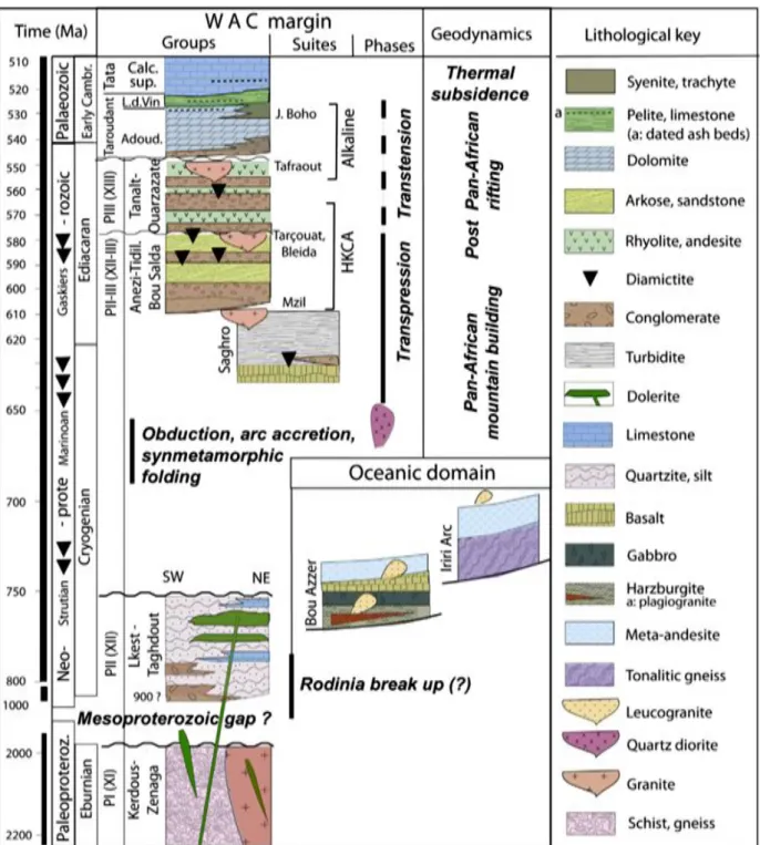
The Anti-Atlas represents the most important segments of the main Pan-African belt system (≈0.5 Ga) of North Africa. Globally, the Variscan deformation of the Anti-Atlas is very heterogeneous and mainly shows a thick-skinned type.
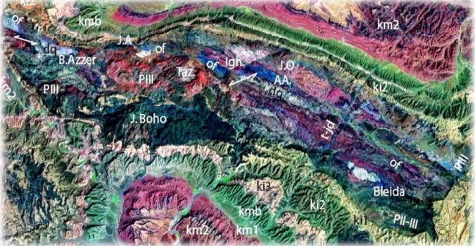
Agdz- Bou Azzer- Agdz (180 km) Itinerary: Figures 1.1, 1.2
- Tectonites (serpentinites)
- Ultramafic and mafic Cumulates
- Intrusions of quartz diorite
- Sheeted dyke complex
- Basic lavas
- Volcano-sedimentary series
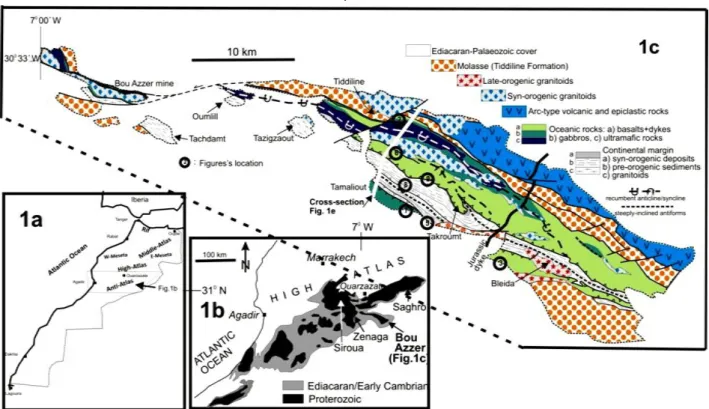
The Bou-Azzer ophiolite complex, 4 to 5 km thick, is located in the central part of the Anti-Atlas Mountains. Undeformed calc-alkaline Bleida granodiorite Ma, U–Pb, zircons; Inglis et al., 2004) is exposed in the SE part of the Bou Azzer inlier (Figure 1.3), which is located within the WAC platform volcano-sedimentary sequence.
Agdz- Tazenakht- Agdz (160 km)
The road passes through Quaternary and Neogene continental sediments accumulated on top of Paleoproterozoic shales. The road passes through Quaternary and Neogene continental sediments accumulated on top of Paleoproterozoic shales.

Lhou Maacha, Directeur Général de l’Exploration et Développement , MANAGEM Abdellah Mouttaqi, Directeur du Pôle Exploration et Technique, ONHYM
Conférence plénière N°1
Professeur Omar Saddiqi, Doyen de la Faculté des Sciences Aïn Chock
Géologie du Maroc : Quoi de neuf…?”
Conférence plénière N°2
Professeur Fernando Bea, Université de Grenade, Espagne
Province Alkaline de la partie occidentale de la dorsale
At first glance, Morocco's topography is similar to that of its neighbors in North Africa. On the one hand, the altitude of most of the country (except the Rif and Atlantic areas) is particularly high [1]. A branch of the Atlas system extends diagonally across the Mesetan domain, namely the Middle Atlas, which is over 3000 meters high.
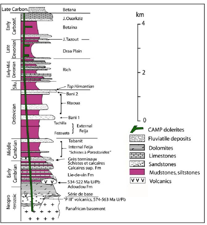
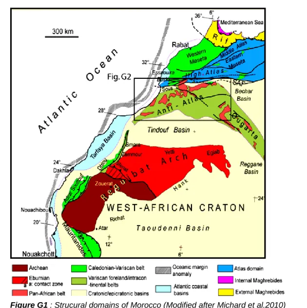
The northern boundary of the Sub-Saharan domain also rises and forms a massive mountain belt, the Anti-Atlas, up to 2700 m high in S. East-vergent thrusts that rework Precambrian material formed during the Carboniferous on the western edge of the Reguibat Arch was placed (Adrar Souttouf), in the northern continuation of the Mauritanide belt. The Late Permian or, more generally, Triassic unconformity marks the end of the Variscan evolution.
The disharmony among the Cambrian formations of the Anti-Atlas records the end of Pan-African evolution.

The curvature of the present-day Variscan arc has inspired many tectonic models, with little agreement among them. Early palaeomagnetic studies in the Cantabrian Zone were used to test the various proposed rotational models and showed that at least part of the arc curvature is of a secondary nature. When all available paleomagnetic field means of components B and C are compared to deviations in the structural trend around the outer Cantabrian-Asturian provinces.
In the allochthonous complexes of NW Iberia, the tectonothermal development of the continental terranes bounding the Variscan suture zone records two successive deep subduction events. The development of two high-P events alternated with the opening of an ephemeral oceanic basin, probably of the rift type, in the Early Devonian. This ephemeral oceanic domain is proposed as the site for the protoliths of the most common ophiolites involved in the Variscan suture along the belt, dated at c.
However, the new evidence from the allochthonous terranes of the Variscan belt suggests a more complex scenario for the assembly of the supercontinent, with an interaction between the colliding continental margins that started earlier and lasted longer than previously thought.
Cabo Ortegal Complex, NW Iberian Massif)
NORTHERN REHAMNA, WESTERN MESETA, MOROCCO)
Dans la partie est de La Boutonnière, la minéralisation aurifère de Bleida Far West, située à 7 km au nord-ouest de l'ancienne mine de cuivre de Bleida, est principalement contrôlée par une phase de déformation majeure, qui s'explique par la brèche intense qui génère une minéralisation relativement riche surtout en EPG en palladium (Pd). Maar Lechmine n'Aït el Haj fait partie d'un complexe volcanique quaternaire situé dans la partie nord-est de la province volcanique des Causse du Moyen Atlas. La présence de niveaux pyroclastiques argileux avec des images de fissures de dessiccation au sommet de la série phréatomagmatique pourrait faire référence à une source d'eau superficielle (piscine, ruisseau, etc.) entrée en contact avec le magma.
La serpentinite noire, la roche qui entoure la minéralisation, obtient cette caractéristique (couleur) en raison de la richesse en minéraux (chromite, pyrite, oxyde de fer). Elle est fortement fracturée et entrecoupée d'un réseau dense de veines et de veinules qui contiennent la minéralisation. Disséminée la chalcopyrite dans la serpentinite pourrait provenir d'une recristallisation de chalcopyrite fissurée après d'importants phénomènes de boudinage.
Afin de poursuivre l'évaluation du potentiel voire l'exploitation du cuivre dans la série Ambed, certaines études approfondies (analyses à la microsonde, analyse isotopique, etc.) seront indispensables, tout en suivant le comportement établi par nos résultats, à savoir, cassure du présent dans les serpentinites noires (veines et veines) et possible source d'intrusion plutonique pour la recristallisation de vastes zones de minéraux de cuivre non déformés.
South Spain): a proxy to dehydration processes taking place during subduction
Its use allowed to raise pHs to values of around 6.5 and 7.1, and led to a decrease in the leached toxic metals that probably contaminate the water sources in the region. This experimental protocol yielded promising results regarding the effectiveness of these alkali amendments in stabilizing mine tailings and mitigating the DMA phenomenon in the mine site of Kettara. Other linear structures were extracted from the photo interpretation of the hills applied to the Digital Terrain Model.
The paleoposition of the Iberian massif zones before amalgamation is still a subject of considerable debate. 2010) proposed a new Cambro-Ordovician position for the Central Iberian Zone (CIZ), north of the Saraha Metacraton. Here we look at the position of the Ossa-Morena Zone (OMZ) in relation to the birth of the Rheic Ocean and the subsequent amalgamation of Iberia. The magmatism pattern and the new Cambro-Ordovician paleogeographic position of the OMZ are temporally and compositionally consistent with a west-east rift distribution, such as the Ethiopia Rift-Red Sea margin (Pearce, 2008).
This corresponds to an east-propagating rift that, we suggest, was a 'Gondwanaward' Rheic Ocean branch, which appears to have been preserved in the Badajoz-Cordoba sinistral subduction shear zone during the Ordovician-Devonian juxtaposition of the OMZ and the CIZ .
BHILISSE Mohamed
Résumé
ORIENTAL, MAROC)
Il appartient au Massif Central Marocain et fait partie de l'anticlinorium Kasbat-Tadla-Azrou, constitué essentiellement de terrains sédimentaires paléozoïques de l'Ordovicien au Carbonifère. Ces sols ont été déformés par les différentes phases de l'orogenèse hercynienne, structurant toute la région du Maroc Central en un ensemble d'anticlinoriums et de synclinoriums, avec le développement de grandes zones de cisaillement et associés à la mise en place d'un magmatisme majoritairement granitique. Cette dernière est étudiée pour déterminer les conditions de dépôt de l'or, caractériser les fluides minéralisants et cartographier le champ hydrothermal.
Les résultats de l'étude aéromagnétique ont démontré que les complexes magmatiques présentent une faible anomalie magnétique comparativement aux autres formations auxquelles sont reliées les veines de quartz aurifères. Leur composition minéralogique est simple et comprend principalement du quartz (92 %), de la tourmaline (~2 %), de la muscovite (~1 %), de la séricite (~2 %) et de la calcite rare. La paragenèse sulfurée est représentée simplement et faiblement par la pyrite et la chalcopyrite avec leurs produits d'altération (hydroxydes de fer, covelline, etc.).
En bref, l'or est associé à la phase tardive de l'altération hydrothermale, où il est associé aux tourmalines ou aux sulfures inclus dans le réseau cristallin de ces dernières.
Atlas oriental, Maroc) : Implications métallogéniques et géodynamiques
Taourgha dans le massif du bas Draa, (ii) granite de Tafraout dans la boutonnière de Kerdous et (iii) granite de Sidi Lhoussaine dans la boutonnière de Zenaga. Datation U/Pb du zircon pour fournir des âges de cristallisation précis des magmas. Des analyses géochimiques (éléments majeurs, éléments traces et terres rares) permettront la caractérisation des affiliations magmatiques et leur classification dans leur environnement géodynamique.
Analyses isotopiques de Nd, Sr et Pb pour clarifier la nature des sources magmatiques. Une comparaison avec des roches magmatiques du même âge connues dans la chaîne de l'Anti-Atlas, telles que les granitoïdes et volcanites de la vallée de Tifnoute sur le promontoire de l'Ouzalagh, les intrusions de la boutonnière d'Imiter dans le Saghro, contribuera à proposer un modèle géodynamique. de la chaîne panafricaine Anti-Atlas. Les retombées scientifiques et économiques de ces travaux, qui permettront d'identifier et d'estimer le potentiel géothermique des réservoirs basiques et sédimentaires des bassins du Souss et de la marge atlantique du Maroc, serviront de guide pour toute utilisation directe en agriculture, pisciculture, thermalisme et usage domestique. chauffage.
Mots clés : potentiel géothermique, réservoirs de socle, réservoirs sédimentaires, réseau poreux, failles, boutonnière, granite, géochimie, marge atlantique, Maroc.
MOYEN-ATLAS, MAROC
Ces études, basées sur des méthodes classiques, ont créé une base de données très riche. Utiliser les produits et techniques de télédétection et SIG pour obtenir les résultats obtenus par les méthodes traditionnelles. Standard (échange d'expériences et évaluation de la faisabilité du projet) - Correction et réorientation des objectifs si nécessaire.
The opportunity to observe directly the magma chambers that fed the volcanic complexes of the Miocene makes Fuerteventura one of the most special islands of the Canary archipelago. Although there are several studies dealing with the growth and collapse history of the Fuerteventura volcanoes, there is still no study that attempts to link the emplacement and growth of the feeder magma chambers (shallow plutons) with the possible impact they may have had on the development of the volcano. collapses on the island. Therefore, a combination of several magmatic intrusion events and other factors that may also promote flank instability, such as hydrothermal activity, are proposed as the causes of the collapse of at least the Central Miocene volcanic complex in Fuerteventura.
In addition, a relatively long period of erosion - from late Miocene to Pliocene time - on the island would also have contributed to the dismantling of the Miocene volcanic complexes and the associated exposure of the magma chambers.
POLYPHASEE
L'exemple du volcan d’Aguelmane Sidi Ali (Moyen-Atlas)
RESUME
Amine Najih 1 , Abdelilah Fekkak 1 , Brahim Karaoui², Abdelkader Mahmoudi 2 , Ilyass Berrada 1 , Hannane Mekraoui 1