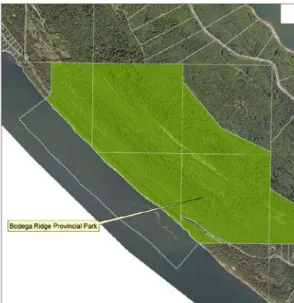
Restorative Learning Center (District Lot 57), District Lot 58 Nature Preserve, Great Beaver Swamp Nature Preserve, Pebble Beach Nature Preserve, Laughlin Lake Nature Preserve, and Bodega Ridge Provincial Park. The reserve protects the remainder of the Great Beaver Marsh (approximately 1.5 hectares of the 6 hectare wetland) and provincially listed ecological communities and threatened species including: waterfowl, songbirds and many other species associated with freshwater systems. The Islands Trust manages nature reserves to ensure that ecological communities and native species are protected in perpetuity.
The main purpose of the reserve is to provide a protected habitat where species and ecosystems can thrive with minimal human interference. The DL 58 Nature Reserve Management Plan provides details of history, property information, maps, photographs, ecological inventory and recommended action items. The action items will be addressed in order of priority by Islands Trust Fund staff, as resources permit.
The DL 58 Nature Reserve will be protected and managed in perpetuity to ensure that natural processes can flourish with minimal human intervention. Ken Millard and the Galiano Conservancy Association (GCA) for establishing a network of protected areas across the island and initiating the land transfer of DL 58 and raising funds;
Introduction
Islands Trust Fund and the Trust Fund Board
Islands Trust Fund Nature Reserves are managed to maintain, preserve and protect the natural features and values of ecosystems.
Islands Trust Fund Management Plans
Nature Reserve Purpose
Nature Reserve Objectives
Property Information
Location
Legal Description
Site History
- Pre-Contact
- Great Beaver Swamp
- Forestry
- Previous Landowners
Most of the land was logged during two major inroads - in the late 1940s and mid-1980s. A small area along the top of the central main ridge was excluded from these cuts, but appears to have been cleared of high quality in the early 1960s. A network of non-slip paths and roads on the ground was created in connection with the logging.
The East Side Haul Road, it suggests, was the main route for hauling lumber to the dump at the south end of Galiano until the mid-1990s. It now provides access to large wooded areas to the southeast of the property, although the portion that crosses the property is unofficial (ie no easement). The plot was acquired by the Trust Board in April 2013 using Section 99 of the Land Law Act.

Undersurface Rights
Conservation Covenant
The property was purchased by Dr. The plot was acquired by the Trust Fund Board under Section 99 of the Land Title Act in April 2013. viii) causes or allows any native flora on the land to be cut down, removed, defoliated or in any way tampered with;. The Islands Trust Fund is permitted to carry out the following activities if captured and approved by the covenant holder in the management plan:. As an exception to section 4.2 According to the Management Plan, the Owner may: a) install, maintain or replace a reasonable number of signs for the purposes of public safety or to inform the public about the land and facilities.
Official Community Plan
Zoning
Emergency Road Network
Parks and Trail Network
Adjacent Land Use and Connectivity
Mid-Galiano Conservation Network
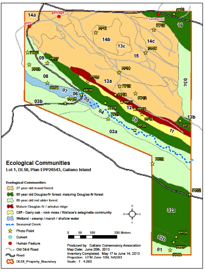
Ecological Inventory
Ecological Significance
Land includes inland threatened bluffs with endangered Garry oak – gray moss / Wallace's selaginella plant association (CDFmm/00 Qgrm). It also includes the southeastern edge of the Great Beaver Swamp, approximately 1.5 acres of the 6-acre wetland complex.
Climate
The months of January and February produce the coldest average temperatures of 4° to 5° Celsius, while July and August are the warmest months with average temperatures of 17° to 19° Celsius. The combined effects of low precipitation, warm temperatures and high number of sunshine hours often lead to an annual moisture deficit on Galiano Island from mid-June to early October. This deficit can often reach drought conditions in areas of recent open plans, such as District Lot 63, and can result in extreme wildfire danger (Erickson, Pebble Beach Nature Reserve Management Plan, 1998).
Geology and Landforms
Hydrology
Soils
Fairbridge: Fairbridge soils are incompletely drained soils that have developed on deep (>100 cm), silty loam to clay over silty clay loam to clay loam marine deposits that are usually stone-free. Trincomali (imperfectly drained): Trincomali soils are moderately well-drained soils that have developed on shallow (30-100 cm) deposits of gravelly sandy clay to gravelly clayey sand textured, marine, fluvial or glaciofluvial materials (15+50% gravel) over gravelly sandy loam to gravelly loam structured, compact, unweathered up to within 100 cm of the surface.
Ecological Designation
Inventory of Biological Features
- Ecological Community 01
- Ecological Community 02
- Ecological Community 03
- Ecological Community 04
- Ecological Community 05
- Ecological Community 06
- Ecological Community 07
- Ecological Community 08
- Ecological Community 09
- Ecological Community 10
- Ecological Community 11
- Ecological Community 12
- Ecological Community 13
- Ecological Community 14
- Ecological Community 15
- Ecological Community 16
Succession: Red alder – nettle dominated area will slowly transition to Douglas fir / Western hemlock (Tsuga heterophylla) over the coming decades, with an increase in shrub cover and a decrease in herbaceous species. Description: Young (65 year old) red alder – nettle dominated the mid to lower north facing slope with a large amount of coarse woody debris on the forest floor. Succession: Red alder – nettle dominated area will slowly transition to Douglas fir / grand silver fir (Abies grandis) / western hemlock over the coming decades, with an increase in shrub cover and a decrease in nettle and other herbaceous species.
Description: Young (65 years old) red alder dominated lower slope and minor depression with western hemlock, western redcedar, grand fir and Douglas fir scattered in the understory. Conifers in the understory will be released and will take over to become a mixed conifer canopy with a red alder / bigleaf maple understory. Wildlife and Wildlife Habitat: Observed during data collection: Deer tracks, red-legged frog, beaver pond and recently chewed/chopped red alder stems.
Wildlife and Wildlife Habitat: Observed during data collection: Swift Hummingbird Habitat: Abundant cavities in red alder thickets and woody debris. Description: Young redwood (60-65 years old) dominated, gently sloping, southwest facing, with well spaced western red spruce and Douglas fir in the sub-canopy. Potential for partial red alder regeneration due to low understory conifer density.
Description: Young red alder (30-35 years old) dominated, highly disturbed area, historically used for gravel and rock extraction. The less disturbed boundaries of the Polygon transition to a red alder – stinging nettle / stinging nettle community with a much lower density of Douglas fir in the sub-canopy. Douglas-fir will eventually take over as the red oak dies out and become the dominant canopy.
Description: Young (27 year old) Douglas fir mixed stand with patches of big leaf maple and red alder throughout. The understory is patchy with sparsely vegetated, primarily Oregon sedge moss areas under dense Douglas-fir canopy interspersed with nettle/clover dominated areas under red alder and bigleaf maple canopy. The cover of red alder and maple will decrease significantly over time, and nettle will also decrease in the understory.
Small patches of red alder and scattered individuals are also recorded in the Polygon, mainly along the boundary of Polygon 15. Description: Young (45-50 year old) Douglas fir – salal (CDFmm01) dominated a gentle, north-facing slope with a more recent logged, 27 year old Douglas fir/red alder/bigleaf maple patch in the northeast corner of the Polygon along an old road.
Community Consultation
First Nations Communications
Management Plan
Vision
Discussion
Management
First Nations
Inclusion of First Nations values, history and perspective should be a priority in the 2018 revision of this management plan. That the Islands Trust/Galiano Conservancy Association consult/communicate with First Nations who have a historical and current interest in the nature reserve area.
Trails
Along one of the old logging roads/paths in the nature reserve is a series of rubbish piles. Removing the gate would cause soil erosion and landscape changes, which are in violation of the covenant. That the Islands Trust Fund and the Galiano Conservancy Association are working together to develop a trail to connect Great Beaver Swamp with District Lot 57.
That Islands Trust Fund and Galiano Conservancy Association are monitoring the trail near Great Beaver Swamp, closing the trail if deemed impassable and considering alternate routes.
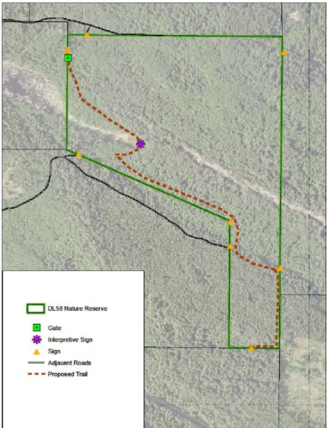
Signage
Prohibited Uses
Neighbors, community members and the Galiano Conservancy Association play a central role in dealing with prohibited activities. That the Islands Trust Fund asks community members to report any prohibited activities observed in the reserve area to the Islands Trust Fund.
Fire Management
DL 58 Nature Reserve Name
That the Islands Trust Fund is contacting Galiano Community School to find out if the students would be interested in helping to name the reserve.
Scientific Research/Education
Ecological Restoration
Zoning
Emergency Road Access
Monitoring
Action Items
Immediate Actions (0-2 years)
Short term Actions (2-5 years)
Long term Actions (5 years +)
Ongoing Action Items
Conclusion
Appendices
To do this, we are creating a plan that will guide how we manage the property and its features. We are asking the Galiano community, and all those interested in conservation on the islands, to help us develop this plan. How often do you visit any of the protected properties within the Mid-Galiano Conservation Network (Bodega Ridge Provincial Park, Laughlin Lake Nature Reserve, Pebble Beach or Cable Bay Nature Reserve, Great Beaver Swamp or Galiano Learning Center.
What activities do you and/or your family enjoy while visiting the protected properties in the Mid-Galiano Conservation Network? List the wildlife and unique plant species you saw near the new DL 58 Nature Reserve (DL 58), between the Great Beaver Swamp and the Galiano Learning Center (DL57).
