MAI PO INNER DEEP BAY
RAMSAR SITE
MANAGEMENT PLAN
i
PART A
OVERALL REVIEW OF RAMSAR SITE MANAGEMENT PLAN (RSMP)
1. INTRODUCTION 1
1.1 BACKGROUND 1
1.2 RENEWAL OF RAMSAR SITE MANAGEMENT PLAN 1
A1 THE DEVELOPMENTS OF THE RAMSAR CONVENTION 4
A2 A REVIEW AND UPDATE OF GOALS AND OBJECTIVES,
VALUES, MANAGEMENT ZONINGS AND COMPARTMENTS OF THE MANAGEMENT PLAN
8
A3 REVIEW AND UPDATE ON STATUS OF MANAGEMENT
PROGRAMME
23
A4 THE CURRENT IMPLEMENTATION OF RAMSAR CEPA
PROGRMME
66
A5 SILTATION 66
A6 MANGROVE COLONIZATION AND MANAGEMENT 68
A7 WINTERING WATERBIRD CONSERVATION 71
A8 DEVELOPMENT PRESSURE 79
A9 WATER BORNE POLLUTION 87
A10 CONSERVATION AND WISE-USE OF WETLAND 89
A11 CLIMATE CHANGE 93
PART B
MAI PO INNER DEEP BAY RAMSAR SITE MANAGEMENT PLAN (RSMPII)
PREAMBLE 96
RAMSAR SITE MANAGEMENT GOALS AND STRATEGIES 97
SECTION 1. DESCRIPTION 98
1.1 GENERAL SITE INFORMATION 98
1.1.1 LOCATION 98
1.1.2 GENERAL SITE DESCRIPTION 98
1.1.3 SITE BOUNDARIES, ACCESS AND TOPOGRAPHY 98
1.1.3.1 BOUNDARIES 98
1.1.3.2 ACCESS 98
1.1.3.3 TOPOGRAPHY 101
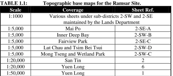
1.1.4 MAP COVERAGE, AERIAL PHOTO AND SATELLITE IMAGERY 101
1.1.4.1 MAP COVERAGE 101
1.1.4.2 AERIAL PHOTO AND SATELLITE IMAGERY 101
1.1.5 LAND TENURE 102
1.1.5.1 GENERAL 102
1.1.5.2 MAI PO MARSHES NATURE RESERVE (MPMNR) 102
1.1.6 HONG KONG WETLAND PARK (HKWP) 103
1.1.7 STATUTORY DESIGNATIONS AND PROVISIONS, AND
PLANNING GUIDELINES
103
1.1.7.1 WILD ANIMALS PROTECTION ORDINANCE (CAP. 170) 107
1.1.7.2 OUTLINE ZONING PLANS (OZP) UNDER TOWN PLANNING ORDINANCE (CAP 131)
ii
1.1.7.4 WETLAND CONSERVATION AREA AND WETLAND BUFFER
AREA
110
1.1.7.5 LAND USE ZONING OF THE RAMSAR SITE 111
1.1.7.6 ENVIRONMENTAL IMPACT ASSESSMENT ORDINANCE (CAP. 499)
112
1.1.7.7 PUBLIC ORDER ORDINANCE (CAP. 245) 112
1.1.7.8 DEEP BAY WATER CONTROL ZONE 112
1.1.7.9 DRAINAGE RESERVES 112
1.1.7.10 FORESTS AND COUNTRYSIDE ORDINANCE (CAP.96) 112
1.2 RAMSAR CONVENTION MATTERS AND CONSERVATION MANAGEMENT
113
1.2.1 CONSERVATION MANAGEMENT STRUCTURE 113
1.2.1.1 AGRICULTURE, FISHERIES AND CONSERVATION DEPARTMENT (AFCD)
113
1.2.1.2 NATURE CONSERVATION SUBCOMMITTEE 114
1.2.1.3 WORLD WIDE FUND FOR NATURE HONG KONG (WWFHK) 114
1.3 ENVIRONMENTAL DESCRIPTION 116
1.3.1 PHYSICAL 116
1.3.1.1 CLIMATE 116
1.3.1.2 HYDROLOGY 116
1.3.1.3 GEOLOGY 118
1.3.1.4 GEOMORPHOLOGY 118
1.3.1.5 SOILS/SUBSTRATES 119
1.3.2 BIOLOGICAL 119
1.3.2.1 OVERVIEW 119
1.3.2.2 FLORA 120
1.3.2.3 FAUNA 122
1.4 CULTURAL 127
1.4.1 HISTORIC / PAST LAND USE 127
1.4.2 CURRENT LAND USE WITHIN RAMSAR SITE 127
1.4.3 COMMUNICATION, EDUCATION, PARTICIPATION AND
AWARENESS (CEPA) PROGRAMMES OF RAMSAR CONVENTION
129
SECTION 2. EVALUATION, GOALS AND MANAGEMENT ISSUES 131
2.1 VALUES OF THE SITE AS A RAMSAR SITE 131
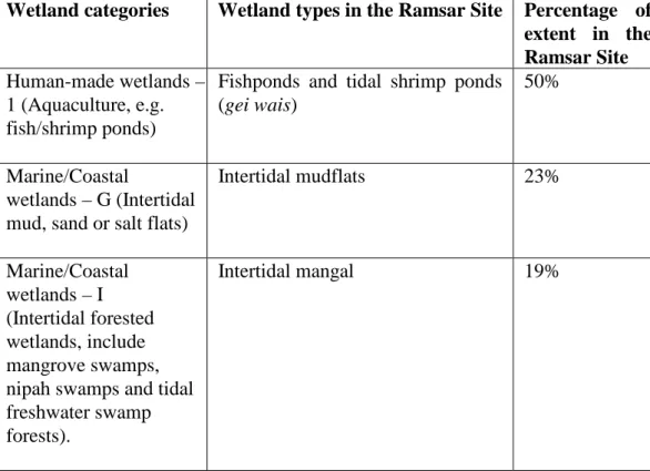
2.1.1 WETLAND TYPES IN THE RAMSAR SITE 131
2.1.2 DESIGNATION CRITERIA AS A RAMSAR SITE 132
2.1.2.1 GROUP B OF THE CRITERIA: SITES OF INTERNATIONAL IMPORTANCE FOR CONSERVING BIODIVERSITY.
CRITERIA BASED ON SPECIES AND ECOLOGICAL COMMUNITIES
133
2.1.2.2 GROUP B OF THE CRITERIA: SITES OF INTERNATIONAL IMPORTANCE FOR CONSERVING BIODIVERSITY.
CRITERIA BASED ON WATERBIRDS.
iii
2.2.1 ECOLOGICAL EVALUATION 135
2.2.1.1 SIZE 135
2.2.1.2 BIOLOGICAL DIVERSITY 135
2.2.1.3 NATURALNESS 136
2.2.1.4 RARITY 136
2.2.1.5 FRAGILITY 137
2.2.1.6 TYPICALNESS 137
2.2.1.7 NOTEWORTHY FLORA 137
2.2.1.8 NOTEWORTHY FAUNA 138
2.2.1.9 RECORDED HISTORY 140
2.2.1.10 POTENTIAL FOR IMPROVEMENT 140
2.2.2 EVALUATION OF OTHER VALUES 142
2.2.2.1 SOCIAL, ECONOMIC AND CULTURAL VALUES 142
2.2.2.2 COMMUNICATION, EDUCATION, PARTICIPATION AND AWARENESS VALUES
143
2.2.2.3 RESEARCH AND STUDY VALUES 144
2.2.2.4 OTHER VALUES 144
2.3 FACTORS INFLUENCING SITE MANAGEMENT 145
2.3.1 NATURAL TRENDS 145
2.3.1.1 SILTATION 145
2.3.1.2 VEGETATION SUCCESSION 145
2.3.1.3 WINTERING WATERBIRD POPULATION TRENDS 145
2.3.1.4 PESTS 146
2.3.1.5 WILD BIRDS AND AVIAN FLU 146
2.3.2 HUMAN-INDUCED TRENDS 147
2.3.2.1 DEVELOPMENT PRESSURE 147
2.3.2.2 FISH POND MANAGEMENT 147
2.3.2.3 EXOTIC SPECIES 153
2.3.3 TENURE AND STATUTORY CONSTRAINTS 155
2.3.4 EXTERNAL IMPACTS 155
2.3.4.1 WATER POLLUTION 155
2.3.4.2 DRAINAGE AND RIVER DIVERSION 157
2.3.5 VISITOR DEMAND 159
2.4 GOALS AND OBJECTIVES 161
2.5 THE RENEWED MANAGEMENT PLAN – RSMPII 168
2.5.1 THE MANAGEMENT OBJECTIVES 168
2.5.1.1 CORE ZONE 168
2.5.1.2 BIODIVERSITY MANAGEMENT ZONE 169
2.5.1.3 WISE USE ZONE 171
2.5.1.4 PRIVATE LAND ZONE 172
2.6 MONITORING PROGRAMME 174
2.6.1 BASELINE MONITORING SCHEME 174
iv
3.1 GOALS AND STRATEGIES 176
3.1.1 GOAL 1. WISE USE 177
3.1.2 GOAL 2. WETLANDS OF INTERNATIONAL IMPORTANCE 181
3.1.3 GOAL 3. INTERNATIONAL COOPERATION 182
3.1.4 GOAL 4. INSTITUTIONAL CAPACITY AND EFFECTIVENESS
183
3.2 ACTION TIME TABLE 185
3.3 DESCRIPTION OF NEW PROJECTS 202
Annex Background on Conservation Management of Mai Po area 206
Appendix I List of Plants 208
Appendix II List of Birds 211
Appendix III List of Mammals 219
Appendix IV Lists of Amphibians and Reptiles 220
Appendix V List of Species New to Science 221
Appendix VI-1 List of Butterflies 222
Appendix VI-2 List of Dragonflies 223
Appendix VII List of Fish 225
Appendix VIII Species with important global populations and Species with important biogeographical (flyway) populations
226
Appendix IX Information Sheet on Ramsar Wetlands (RIS) 229 Appendix X CEPA programmes organized by the Hong Kong
Wetland Park
240
Appendix XI Bird surveillance programme in response to H5N1 250 Appendix XII Consultation on the Review and Renewal of the
Ramsar Site Management Plan
252
PART A
1
1.1 BACKGROUND
In 1997, the then Agriculture and Fisheries Department (renamed Agriculture, Fisheries and Conservation Department in 2000 (AFCD)) completed the study on “Development of a Comprehensive Strategy and a Management Plan in Relation to the Listing of Mai Po and Inner Deep Bay as a Wetland of International Importance under the Ramsar Convention” (the Ramsar Site Study) which produced the first Ramsar Site Strategy and Management Plan (RSMP) for Hong Kong.
The RSMP provided a general framework of management zoning and an outlined management programme for the long term conservation and wise use of wetlands of the Ramsar Site at Mai Po and Inner Deep Bay area in Hong Kong. The government adopted the RSMP for implementation in 1998 and regularly reviewed the management programme and issues of concern.
1.2 RENEWAL OF RAMSAR SITE MANAGEMENT PLAN
In 2008-09, an overall review on the implementation of the RSMP has been conducted taking account of actions undertaken in the management programme and updated the status of issues of concern for the renewal of the RSMP. In considering that the implementation of the RSMP is a continuous process, the first RSMP adopted in 1998 was regarded as the first stage of RSMP and the renewed RSMP is regarded as the second stage, referred as RSMPII.
Since the listing of the Mai Po Inner Deep Bay Ramsar Site of Hong Kong in September 1995, there have been developments of the Ramsar Convention as results of several meetings of the Conference of the Parties to the Convention on Wetlands (Ramsar, Iran, 1971) (Ramsar COP). The development of Ramsar Convention relevant to the review and renewal of the RSMP included: the inputs required in the “Information Sheet on Ramsar Wetlands” (RIS) and the “Ramsar National Report” (RNR), the focus of “Ramsar Strategic Plan” and the Ramsar Convention’s programme on communication, education, participation and awareness (CEPA).
2 planning for Ramsar Sites and other wetlands” as outlined in Annex to Resolution VIII.14 adopted at Ramsar COP 8 (Valencia, 2002) which is shown in the figure below:
The documentation on the overall review and renewal of the RSMP is organized into two parts, i.e. Part A: Overall review of RSMP, and Part B: Ramsar Site Management Plan II (RSMPII).
Part A: Overall review of RSMP covered the development of the Ramsar Convention which provided guidance relevant for the continuous implementation of the RSMP, updating on goals and objectives, values, management zonings and compartments, updating on status of the management programme particularly the annual monitoring programmes of the Ramsar Site including the Baseline Ecological Monitoring Programme (BEMP), the Waterbird Monitoring Programme (WMP), habitat mapping projects and also annual habitat management work/ projects carried out by the WWF-Hong Kong (WWFHK) within the Mai Po Marshes Nature Reserve (MPMNR) and the project proposals listed under the RSMP. The current implementation of the CEPA programme by the Hong Kong Wetland Park is briefly accounted.
3
4 summarized in the following paragraphs.
A1. THE DEVELOPMENTS OF THE RAMSAR CONVENTION
Information Sheet on Ramsar Wetlands (RIS), New guidelines for management planning for Ramsar Sites and other wetlands (New Guidelines), Ramsar National Report (RNR), Ramsar Strategic Plan and Ramsar Convention’s programme on communication, education, participation and awareness (CEPA)
The mechanisms/ tools of the Ramsar Convention in guiding Contracting Parties on their management planning, implementation and reporting of progress are: the RIS, New Guidelines, RNR, Ramsar Strategic Plan, and the Ramsar Convention’s CEPA programme which are commonly adopted by all Ramsar Contracting Parties for the conservation and management of the Ramsar Sites worldwide. In the RSMPII, these mechanisms/ tools have been followed closely.
Information Sheet on Ramsar Wetlands (RIS) and New guidelines for management planning for Ramsar Sites and other wetlands (New Guidelines)
The RIS is the means by which Contracting Parties present information on the Ramsar wetlands. This Information Sheet also provides an internationally standardized format for describing wetlands. The items reported include factual data on the Ramsar Site (e.g. altitude, wetland types, locations etc), justification for the Criteria cited for designation of the Ramsar Site, the flora and fauna information, socio-cultural factors, conservation measures and potential threats. The input required for RIS has been regularly updated and reviewed in several COPs. The information in the RIS provided inputs to the “Ramsar Site Database” and forms a basis both for monitoring and analysis of the ecological character of the site and for assessing the status and trends of wetlands regionally and globally.
According to Article 3.2 of the Ramsar Convention, “each Contracting Party shall arrange to be informed at the earliest possible time if the ecological character of any wetland in its territory and included in the List has changed, is changing or is likely to be changed.” Therefore, the description of ecological character of the Ramsar Site is an important part of the management planning process. The ecological descriptions constitute a complementary basis to the RIS for detecting and notifying changes in ecological character. In Resolution VI.13 at Ramsar COP 6 (Brisbane, 1996), it urged the Parties to update and resubmit the RIS for their Ramsar Sites to the Secretariat at least every six years, so as to maintain a certain currency in the data available to the public from the “Ramsar Site Database”. The updating also serves as a management tool for the detection and monitoring of changes of the site over time.
5 such wetland type system was followed.
In order to fulfill the requirement from the Ramsar Convention, the ecological information of the Mai Po Inner Deep Bay Ramsar Site has been updated regularly through the Baseline Ecological Monitoring Programme and Waterbird Monitoring Programme and data so obtained are fed into the RIS for submission to the Ramsar Secretariat.
The Contracting Parties committed themselves earlier in Resolution VI.13 at COP 6 (Brisbane, 1996) to providing updated RIS information for all of their Ramsar Sites no later than every six years or on the occasion of any significant change in the sites' ecological character. At Ramsar COP 8 (Valencia, 2002), the latest version of the RIS and its explanatory note and guidelines were adopted in Resolution VIII.13, with significant additions and changes adopted by COP 9 (Kampala, 2005) in Resolution IX.1 Annex B. Also, in COP 8 (Valencia, 2002) the New Guidelines (Annex to Resolution VIII.14) were adopted which is followed in the RSMPII.
Ramsar National Report (RNR)
The RNRs are official documents of the Ramsar Convention prepared by Contracting Parties before Ramsar COP. The format of the RNR has been approved by the Ramsar Standing Committee for the Contracting Parties. The RNR followed similar format of the Ramsar Strategic Plan in such a way that it reported how a Contracting Party implement the Convention. Indicator questions (which reflected the key result areas) are grouped under each of the Strategies to aid the Contracting Parties to gather information and report on the key aspects of scientific, technical and CEPA implementation under the Ramsar Convention. The RNR not only facilitated reporting on past achievements but also assisted the Contracting Parties in structuring their activities within the framework of the Ramsar Strategic Plan.
Upon receipt and verification of the RNRs, the Ramsar Secretariat would enter the information in a database that will provide basis for reporting by the Secretariat to each COP on the global and regional achievement and the implementation progress of the Convention. RNRs are also made publicly available through their posting on the Ramsar Convention’s website. As the RNRs provide data and information on how the Contracting Parties implement the Ramsar Convention, it also served as a mean for the Contracting Parties to be accountable for their obligations under the Ramsar Convention. At the same time, RNRs are also useful for the Contracting Parties to assess and monitor its progress in implementation, capture lessons for developing future action plans and priorities of management plan.
6 The RNR of all the Ramsar Sites in China (including the Mai Po Inner Deep Bay Ramsar Site which is among the 37 Ramsar Sites of China (as at July 2010)) is prepared by the State Forestry Administration (SFA), the Ramsar Administration Authority of the government of the People’s Republic of China responsible for reporting to Ramsar COP. Information on the progress of implementation of the Ramsar Convention in Hong Kong Mai Po Inner Deep Bay Ramsar Site has been provided to SFA for input into China’s RNR. In adopting/following the general requirements of the Ramsar Strategic Plan and inputs required for RNR in the renewal of RSMP, it also facilitate the data and information input from the Mai Po Inner Deep Bay Ramsar Site for the preparation of RNR by SFA for the next Ramsar COP.
Ramsar Strategic Plan
Since the listing of the Mai Po Inner Deep Bay Ramsar Site in 1995, three Ramsar Strategic Plans have been developed for the operation of Ramsar Convention. The Ramsar Convention’s first Strategic Plan 1997-2002 was adopted by Resolution VI.14 at Ramsar COP 6 (Brisbane, 1996). It was regarded as a ground breaking document as the first plan of its kind for a global environmental Convention. The second Strategic Plan 2003-2008 was adopted by Resolution VIII.25 at Ramsar COP 8 (Valencia, 2002). The second Strategic Plan refined the general and operational objectives by taking into account the fact that a broader approach to wetland conservation and sustainable development was needed.
The current one being the third Strategic Plan for 2009-2015 adopted under Resolution X.1 at Ramsar COP 10 (Changwon, 2008). The Plan set out five Goals which are essentially the five general objectives of the second Plan, i.e. (i) Wise Use of Wetlands, (ii) Development of the Ramsar List, (iii) International Cooperation, (iv) Implementation capacity and (v) Membership in the Convention. In order to achieve these Goals, 28 Strategies with their respective “Key Result Areas” are provided to help Contracting Parties to assess the extent of achievement. These Strategies represented a general consensus of the most important priorities for most Contracting Parties to implement the Convention.
7 In the RSMPII, the NRF of RNR for Ramsar COP10 (Changwon, 2008) is followed and the goals and strategies of the Ramsar Strategic Plan 2009-2015 are adopted and modified to suit the Hong Kong context as appropriate. The ‘Key Result Areas’ of the Ramsar Strategic Plan 2009-2015 served as ‘performance indicators’ on assessing the implementation and achievement of objectives of the Ramsar Convention in Hong Kong. Action Plans or projects listed out the actions required to be undertaken for achieving the Strategies. The Goals, Strategies and Action Plans are further elaborated in Section 3 of the RSMPII.
CEPA programme
The current CEPA Programme is the third one and is intended to be operated for a six-year period (2009-2015) in conjunction with the third Strategic Plan of the Convention adopted at Ramsar COP10 (Changwon, 2008). As the CEPA Programme implemented and develops, there is an evolving approach to include community participation and education in wetland management planning and there is a need for enhancing participatory techniques in the CEPA skills. The CEPA Programme indeed offers tools to help public understand the values of wetlands so that they are motivated to become advocates for wetland conservation and wise use and may act to become involved in relevant policy formulation, planning and management.
8
MANAGEMENT ZONINGS AND COMPARTMENTS OF THE
MANAGEMENT PLAN
Goals and Objectives (Strategies and Action Plans)
The goals and long term objectives adopted in the RSMP which delivers Articles 2, 3, 4 and 5 of the Ramsar Convention are generally valid for RSMPII. In line with the Ramsar Strategic Plan 2009-2015 (Resolution X.1 adopted at Ramsar COP 10 (Changwon, 2008)) which provided guidance on the focus of effort for implementing the Convention, RSMPII followed the Goals (except Goal 5)* listed in Ramsar Strategic Plan 2009-2015 that are relevant to and within the capacity of Hong Kong SAR for implementation are highlighted as follows:
Goals
Goal 1. Wise Use. (In delivery of Articles 3.1, 4.3, 4.4, and 4.5 of the Convention.)
Goal 2. Wetlands of International Importance. (In delivery of Articles 2.1, 2.2, 2.5, 2.6, 3.1, 3.2, 4.1, and 4.2 of the Convention.)
Goal 3. International cooperation. (In delivery of Articles 5 of the Convention.) Goal 4. Institutional capacity and effectiveness. (In delivery of Articles 6.7 and
8 of the Convention.)
(*Goal 5 of the Ramsar Strategic Plan 2009-2015 concerning “Membership” has been excluded as the Goal “To progress towards universal memebership of the Convention” delivers Articles 2.4 and 9 of the Convention and is for action at the Secretariat, Standing Committee and Contracting Parties at the national levels.)
Values and evaluation
During the past 10 years of monitoring under the BEMP of the Ramsar Site, there has been no drastic change detected, as such the values of the Ramsar Site have been more or less maintained. An updated evaluation is presented in Section 2 of RSMPII.
Strategies/ Objectives
9
Review of Management Zones and Compartments
The existing RSMP as implemented since 1998 delineated the Ramsar Site into five different management zones based on the habitat types, ecological values and existing land uses as shown in Figure A1.1, i.e. the Core Zone, the Biodiversity Management Zone, the Wise Use Zone, the Public Access Zone, and the Private Land Zone.
The site characteristics and management intention of the current Management Zones are summarized in the table below:
Management
Zones
Present site characteristics Management Intention
Core Zone An undisturbed, largely natural reference area which include the intertidal mudflat and mangroves along open coastal area where biological interest is concentrated.
Maintenance of natural processes.
Access is generally limited to essential management, monitoring and research purposes.
Biodiversity Management Zone
Ponds and wetland habitats of Mai Po Marshes Nature Reserve.
To provide refuge for waterbirds.
A focus for biodiversity conservation, education and training.
Wise Use Zone Fish Ponds Encourage maintenance and operation of fish ponds in an ecologically sustainable manner.
Act as buffer zones outside the Ramsar Site.
Public Access Zone
Fish Ponds Visitors may have
unrestricted but managed access (subject to
cooperation of individual pond owner) to a part of the Ramsar Site for public education.
Additional function to buffer zones outside Ramsar Site.
Private Land Fish Ponds Recognize private lands status.
10
Zones
ecologically sustainable and consistent with the adjacent management zone.
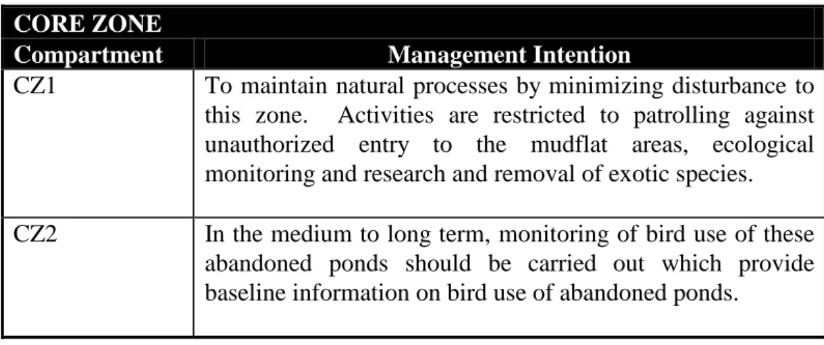
Core Zone (CZs 1-2)
Core Zone 1 (CZ1) covers the mudflat, water channels and the intertidal mangroves in the Inner Deep Bay which are also part of two SSSIs namely Mai Po Marshes and Inner Deep Bay. In order to protect the ecological integrity of the CZ1 from human disturbance, for example, cross boundary fishermen who enter the mudflats to collect mudskippers or setting up nets or traps for harvesting of other marine products, the Restricted Area designated under the Wild Animals Protection Ordinance (Cap 170) was extended to cover the intertidal mudflat areas and shallow waters of Inner Deep Bay. The extended Restricted Area came into effect on 15 February 1996. It should be noted that the Restricted Area does not cover the main water channels where local fishermen and villagers could make use for access.
Whilst possible extension of the core mudflat is limited by deep water areas such as river channels including Shan Pui River and Shenzhen River, the mudflat might have the potential of extending outward to the western side of Tsim Bei Tsui as sedimentation processes takes place. The Ramsar Site boundary and CZ1 could be extended accordingly if it is shown that the ecological values of such “new” potential mudflat area (which could be regarded as an ecological unit) is comparable to that of the existing mudflat in the CZ1. Further studies on the ecological values of any newly formed mudflat and the feasibility of revising the boundary of the management compartment would be required. The detail of the study will be elaborated in Project M3 of Action Plan in Section 3 of RSMPII.
Core Zone 2 (CZ2) covered an isolated island with four abandoned fish ponds. This island is not covered by any land use zoning. It was recommended in the existing RSMP that some non-intervention management of fish ponds could be carried out in these ponds with monitoring to evaluate consequential ecological changes of these abandoned fish ponds. In recent years, while there was no specific non-intervention management being arranged, it was observed that this site has been used by Cormorant and waterbirds such as gulls for roosting during winter. Starting from July 2010, the scope of the monthly waterbird monitoring programme has been extended to cover the bird use of these abandoned ponds. Updated management intentions of the Core Zone compartments are shown in Section 2.5 of RSMPII.
12 According to the Lau Fau Shan and Tsim Bei Tsui Outline Zoning Plan (OZP No. S/YL-LFS/7), the land use zoning of BMZ 1-3 is “SSSI” which recognizes the Site of Special Scientific Interest status. BMZ 1 could be sub-divided into two parts including the wooded area and the gei wai. These two portions are part of the two SSSIs namely the Tsim Bei Tsui Egretry SSSI (TBTE SSSI) and the Inner Deep Bay SSSI (IDB SSSI) respectively. The whole of BMZ 2 is included in TBTE SSSI while the whole of BMZ 3 is within the IDB SSSI. The land use zoning of the Ramsar Site is described in Section 2 of RSMPII and shown in Figure 2.1.
According to the most recent information available, the egretry located at the TBTE SSSI has been abandoned since 1991. As the egretry has been abandoned for a long period of time, the egretry status of the wooded area of BMZ 1 and the BMZ 2 is no longer important. On the other hand, the remaining areas of BMZ1 and BMZ3 are gei wai and abandoned fish ponds respectively which inhabit a number of waterbirds. Egrets/herons and Common Greenshanks are the waterbird species that are commonly found there, some other birds also make use of BMZ 2 as a roosting site.
Proposed Renaming of BMZs 1-3:
The purpose of Biodiversity Management Zone is to provide refuge for waterfowl and a focus for biodiversity conservation, education and training in a relatively intensively managed environment. There is no current habitat management arrangement for BMZs 1-3 due to unclear land ownership issues. In order to allow for alternative management considerations as the complicated land ownership issues may not be easily resolved in the short term, it is proposed to rename these three BMZs to be Wise Use Zone (WUZ), as the existing gei wai and fish ponds there are regarded as wise use of wetlands, as follows:
(i) the original BMZ 1 will be renamed as WUZ 1 in view that it is an existing
gei wai;
13 It should be noted that the proposed renaming of the management compartments would only provide guidance on the objectives of management of the Ramsar Site but would not affect the statutory development control of the sites which is subjected to land use and planning control mechanisms. These compartments are already zoned as SSSI under the Lau Fau Shan and Tsim Bei Tsui OZP (S/YL-LFS/7) and therefore the actual land use for these compartments would be controlled by the statutory planning requirement under the Town Planning Ordinance.
Given that the concerned ponds are within the Priority Sites under the New Nature Conservation Policy, AFCD will keep in view for any opportunity to carry out conservation management works of the subject ponds under the MA scheme.
Consequential renumbering of BMZ 4-10 within the Mai Po Marshes Nature Reserve:
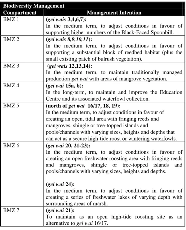
In RSMP, besides BMZs 1- 3, there are seven other compartments of the BMZ zone (i.e. BMZ 4-10) which covered gei wais 3-4, 6-24 of the Mai Po Marshes Nature Reserve (MPMNR). According to the existing RSMP, the broad objective of BMZ in MPMNR is to provide a refuge for waterfowl and a focus on biodiversity conservation, education and training. The MPMNR is sub-divided into seven management compartments which cover different gei wais for different management intentions. WWFHK has carried out habitat management works for each compartment with reference to the existing RSMP. However, WWFHK in the “Management Plan for the Mai Po Marshes Wildlife Education Centre and Nature Reserve 2006-2010” (MPMP 2006-2010) made note that in view of the actual physical conditions and experiences gained from the habitat management works, the management intention and boundaries of some management compartments had been revised.
14
justify the change adopted in the Mai Po Management Plan 2006-2010 BMZ 6 (gei wais
12,13,14):
Management intention:
In the long term, to maintain traditionally managed production gei wai with areas of mangrove vegetation.
It was suggested to convert
gei wai 14 as a settling pond for saline water before it enters gei wai 16/17. It is noted that the floor of
gei wai 16/17 is higher than that in gei wai 14, it would not be feasible for water to flow from gei wai 14 to 16/17 without large scale earth moving works.
No need to change the boundaries of this BMZ but the proposal for converting gei wai
14 as a settling pond was not implemented.
BMZ 7 (gei wai 15a, b): In the long-term, to maintain and improve the Education Centre and its associated waterfowl collection.
In recent years, gei wai 15c and Pond 16b has been developed for education purposed.
In 2007, enhancement works had been completed in gei wai 17b and it has been turned into a freshwater habitat.
Gei wai 17b was in BMZ 8 in the Plan which was intended to be filled by treated wastewater from Fairview Park. However, such proposal was not carried forward anymore.
It was suggested that the boundary of BMZ 7 enlarged to include
gei wai 15c, 16b and 17b for education purposes.
BMZ 8 (gei wai 15c, east of 16/17, east of 18 and 19, 23):
In the medium term, adjust conditions in favour of creating an open freshwater roosting area with fringing reeds and mangroves, shingle or tree-topped islands and pools/channels with varying sizes, heights and depths.
It was suggested in the MPMP that treated wastewater from the Fairview Park can be discharged into gei wai 15c, then passed to gei wai 17b, then to the landward halves of gei wai 18 and 19 and finally into gei wai 23 before it is discharged through its sluice gate into the Fairview Nullah. However, since the treated effluent still has a high level of phosphate, the proposal is considered impractical. Also, no earth moving works had been carried out
15
justify the change adopted in the Mai Po Management Plan 2006-2010 to divide the gei wai 18 and
19 into ‘landward’ and ‘seaward’ parts.
BMZ 9 (gei wai 16/17 (west), 18 and 19 (west), 20, 21, 22): In the medium term, adjust conditions in favour of creating an open, tidal area with fringing reeds and mangroves, shingle or tree-topped islands and pools/channels with varying sizes, heights and depths that can act as a secure high-tide roost or wintering waterfowls.
The whole gei wai 18 & 19 will be used as tidal high-tide roost as no earth moving works had been carried out to divide the gei wai 18 and 19 into
‘landward’ and ‘seaward’ parts.
Gei wai 21 will be enhanced as an alternative high-tide roost by dredging away the reeds and mangrove there so that a larger area of shallow water, mud and low islands would be created for roosting waterbirds. The enhancement works would be completed in 2009.
Gei wai 20 & 22 which are originally in BMZ 9 are being successfully managed as a rain-fed pond for wintering waterfowl,
It was suggested that the boundary of BMZ 9 to be revised to include gei wai
16a/17a, the whole of
gei wai 18, 19 and 21. As the former three
gei wai are adjacent to each other, it was suggested to use BMZ 9a for 16/17-19 whist the isolated gei wai 21 will be renamed as BMZ 9b.
BMZ 10 (gei wai 24): In the medium term, to adjust conditions in favour of creating a series of freshwater lakes of varying depth with surrounding areas of marsh.
As the intention of BMZ 10 is similar to that of BMZ 8, it is considered that these two BMZ should be merged to improve efficiency.
It was suggested that BMZ 10 to be merged within the boundary of the revised BMZ 8 and therefore BMZ 10 is to be deleted.
16 In order to rectify the change of boundaries of BMZ compartments made in the MPMP 2006-2010 and to streamline the numbering sequence of all BMZs due to the proposed renaming of the BMZ 1-3 (renamed as WUZ 1-2 as discussed above) to WUZ, renumbering of the respective compartment numbers of the BMZs inside the MPMNR is proposed as follows:
BMZ compartments Proposed renumbering
BMZ 4 BMZ 1
BMZ 5 BMZ 2
BMZ 6 BMZ 3
BMZ 7 BMZ 4
BMZ 8 BMZ 6
BMZ 9a BMZ 5
17
PUBLIC ACCESS ZONE (PAZS 1-2)
The two existing Public Access Zones (PAZs) in the existing Plan are mainly fish ponds and also included a section of the Tin Shui Wai drainage channel. They are located at the north eastern side of the Hong Kong Wetland Park (HKWP) and along the northern boundary of the proposed Wetland Nature Reserve (WNR) of the proposed development site at Fung Lok Wai. The two PAZs are zoned ‘SSSI’ as they are part of the IDB SSSI, the remaining portions are zoned ‘Conservation Area’ (CA) on the approved Lau Fau Shan and Tsim Bei Tsui OZP Plan No. Z/YL-LFS/7 (see Figure 2.1) to protect these fish ponds from incompatible developments. The section of the water channel is not covered by any land use zoning.
The operators of several existing fish ponds in PAZ 1 and PAZ 2 participated in the Accredited Fish Farm Scheme managed by AFCD which are detailed in Section 2 of RSMPII. The fish ponds within PAZ 1 and PAZ 2 are in fact contiguous with the proposed enhanced fish ponds in the proposed WNR at Fung Lok Wai (Private Land zone at Fung Lok Wai). Since the establishment of the HKWP, it has taken up the role for public education and awareness programmes on wetland conservation and there is no need to develop the two PAZs for public awareness programmes. As such, to reflect more appropriately their existing function as a fish pond in the Ramsar Site, the PAZ would be renamed as Wise Use Zone (WUZ).
In considering that the drainage channel is regarded as a kind of ‘wise use’ of wetland and the channel at Tin Shui Wai which forms part of the original PAZ 1 would be renamed as a Wise Use Zone compartment as follows:
(i) the outlet of the drainage channel at Tin Shui Wai to be renamed as WUZ 3
18
WISE USE ZONES (WUZS)
The updated definition of ‘Wise Use’ as defined in the Ramsar Handbook 1 – Wise Use of Wetlands is: “Wise Use of wetlands is the maintenance of their ecological character, achieved through the implementation of ecosystem approaches, within the context of sustainable development.” An elaboration of the Wise Use concept is also provided in the Handbook which stated that “Within the context of ecosystem approaches, planning processes for promoting the delivery of wetland ecosystem benefits/services should be formulated and implemented in the context of the maintenance or enhancement, as appropriate, of wetland ecological character at appropriate spatial and temporal scales.”
Fish pond operation and water channels are regarded as wise use of wetland. It is therefore important that in consideration of the change of land use within the Wise Use Zones, the ecological functions of these fish ponds and water channels should be maintained so that they will continue to provide feeding and roosting sites for wintering waterbirds in the Ramsar Site.
There are altogether 10 compartments in Wise Use Zones (WUZ) in the existing RSMP and they are covered by two types of land use zonings, namely SSSI and CA as listed below:
WUZ compartment
Land Use Zoning
OZP No.
WUZ 1 Unzoned
(water channel)
-
WUZ 2 SSSI (1) Mai Po & Fairview Park OZP Plan No. S/YL-MP/6
WUZ 3 CA Nam Sang Wai OZP Plan No. S/YL-NSW/8
WUZ 4 CA Mai Po & Fairview Park OZP Plan No. S/YL-MP/6 WUZ 5 CA Mai Po & Fairview Park OZP Plan No. S/YL-MP/6 WUZ 6 CA Mai Po & Fairview Park OZP Plan No. S/YL-MP/6 WUZ 7 SSSI Mai Po & Fairview Park OZP Plan No. S/YL-MP/6 WUZ 8 CA Mai Po & Fairview Park OZP Plan No. S/YL-MP/6 WUZ 9 CA Mai Po & Fairview Park OZP Plan No. S/YL-MP/6 WUZ 10 CA San Tin OZP Plan No. S/YL-ST/8
As specified in the existing RSMP, management zones are sub-divided into different compartments which will have different management activities. Therefore, compartments of a management zone delineate areas within that zone which will be managed for the same purpose. The boundaries of the compartments are not fixed permanently but could be changed as an understanding of particular situation develops. The compartments are also identified on the basis of the existing situation and the need to simplify management as much as possible.
19 have taken into account their locations and existing conditions.
WUZ 1to be renumbered as WUZ 5
This zone consists of two drainage channels originated from the Kam Tin River and Shan Pui River. This drainage area is important for flood alleviation for the whole North West N.T. area which is also regarded as a kind of wise use of wetlands. It is subjected to routine maintenance dredging by the Drainage Service Department to maintain water flow and the management intention of this zone remains unchanged. In view of the renaming of BMZs 3 as WUZs 2, PAZs 1-2 as WUZs 3-4 and in order to streamline the sequencing in the numbering of the WUZ compartments, it is proposed to renumber WUZ 2 as WUZ 5 in the RSMPII.
WUZ 2 to be renumbered as WUZ 6
This zone consists of contiguous fish ponds at Lut Chau to the south of the MPMNR which is also part of the Mai Po Marshes SSSI. WUZ 2 together with the ‘Private Land Zone’ at Lut Chau are zoned Site of Special Scientific Interest (1) zone on the Mai Po & Fairview Park OZP Plan No. S/YL-MP/6 (OZP Plan). As specified in the Notes of the OZP Plan, any development or redevelopment within the SSSI (1) zone is required to be developed in a comprehensive and integrated manner with the fish pond areas in Nam Sang Wai which is zoned OU(CDWEA1) on the Nam Sang Wai OZP. While the planning intention of this zone is to conserve ecological value and function of the existing fish ponds, alternative ecologically beneficial uses in the form of a nature reserve with similar ecological function may be considered. It is also noted that quite a number of fish ponds within this zone are under the Accredited Fish Farm Scheme which means aquaculture activities within this zone are still active.
In view of its unique development requirement as specified by the OZP which is different from the other WUZ, it should be maintained as a separate compartment of the WUZ and be renumbered as WUZ 6 in the RSMPII.
WUZ 3 and 4 to be grouped and renumbered as WUZ 7
These zones are zoned CA to protect the ecological integrity of the Ramsar Site. Some of these fish ponds are managed under the Accredited Fish Farm Scheme while some are under license for fish pond operations. In view that the fish ponds within these two zones form contiguous and continuous fish pond networks and there is no difference in the management intention of these two zones, it is proposed to group them together to form one WUZ compartment and be renumbered as WUZ 7 in the RSMPII.
WUZ 5 to be renumbered as WUZ 8
20 renamed as WUZ 8 in the RSMPII.
WUZ 6,8,9,10 to be grouped and be renumbered as WUZ 9
WUZ 6 consists of fish ponds arranged in a linear manner separating the BMZ 4 and 5 of the MPMNR from the private land at Pak Hok Chau. AFCD’s warden post is also located within this zone. The fish ponds within this zone served as an important buffer for protection of the MPMNR. A large portion of the fish ponds within this zone are under the Accredited Fish Farm Scheme meaning that the fish ponds within this zone are under active management.
The original WUZ 8 contained the Peter Scott Field Study Centre and the police post at Tam Kon Chau. The two larger ponds at the northern portion of the zone are under ‘Government Land Allocation’ which are abandoned ponds possibly restored after the Shenzhen River regulatory project.
Several fish ponds within the WUZ 9 are under active management and joined the Accredited Fish Farm Scheme. In fact, it is considered that the fish ponds within these four zones form a continuous and contiguous fishponds networks which connected with the other fish ponds in the WCA, there is in fact no difference in the management objectives among the four compartments, Therefore, it is proposed to group these four compartments in one WUZ compartment and be renumbered as WUZ 9 in the RSMPII.
WUZ 7 to be renumbered as WUZ 10
21
compartment Proposed changes
BMZ 1 WUZ 1
BMZ 2 + BMZ 3 WUZ 2
Water channel of PAZ 1 WUZ 3
PAZ 1 + PAZ 2 WUZ 4
WUZ 1 (water channels) WUZ 5
WUZ 2 WUZ 6
WUZ 3 + WUZ 4 WUZ 7
WUZ 5 WUZ 8
WUZ 6, 8, 9, 10 WUZ 9
WUZ 7 WUZ 10
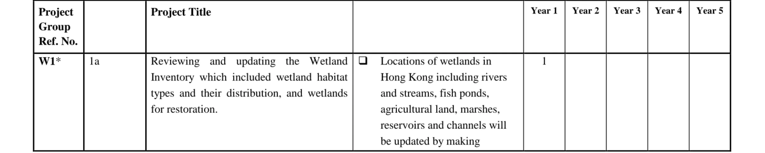
23 The RSMP suggested groups of projects for the action plan/ management programme. The projects that had been achieved are listed in Table 1. Projects which had been partly achieved are listed in Table 2 and for projects that had not been proceeded further are listed in Table 3 with their present status updated for further action as appropriate.
TABLE 1
Management Objectives of the original Management Plan
Relevant Project Groups Project Titles Progress
Establish and maintain the institutional infrastructure, staff capacity, equipment, planning and reporting systems, work schedules and other resources required to manage the Ramsar Site adequately.
IN1: Ramsar Management Authority (RMA) IN2: Staff Structure and Recruitment
IN3: Staff Training IN4: Infrastructure Development IN5: Infrastructure Maintenance IN6: Equipment IN7: Supplies and Consumables IN8: Finance
MP1:Project Register MP2 Management Plan Review
MP3:Ramsar Site Monitoring Digest
IN 1/1- 1/2
All projects of the management programme have been achieved as follows:
IN1/1-1/2: The Wetland Advisory
Committee (WAC) was set up in February 1999 to advice on the initial
24
original Management Plan
IN 2/1- 2/13
IN 3/1-3/2
IN 5/1
IN4/1 and IN 5/2
the Advisory Council on the Environment.
IN2/1-2/13: The Wetland and Fauna Conservation Division was established in 1998 in AFCD and has been responsible for matters on the implementation of Ramsar Convention and conservation management of the Ramsar Site such as the deployment of staff to take law enforcement action, arrangement of monitoring programmes, habitat management works as detailed in the RSMP.
IN3/1-3/2: Relevant training on
administrative procedures, legislations and monitoring techniques etc have been arranged.
IN5/1. Mai Po Warden Post: the existing warden post at Mai Po is maintained.
25
original Management Plan
IN 4/2 and IN 5/3
IN 6/1-6/6 IN 7/1-7/4
IN 8/1-8/2
established at Nam Sang Wai instead of Tsim Bei Tsui. The management center has been operational since 2006 (with the support of the Mai Po Nature Warden Post) and provided facilities as described by Project IN 4/1. Prior to the
establishment of this management centre, the main office was located in Yuen Long Government Offices with the support of the Mai Po Nature Warden Post.
IN 4/2 and IN 5/3. Paths and Hides: Hides have been developed in the Hong Kong Wetland Park (HKWP) by the AFCD as the Ramsar Management Authority (RMA). The paths in the HKWP and those in Nam Sang Wai are maintained by the government. Hides and paths in Mai Po Marshes Nature Reserve (MPMNR) are maintained by WWFHK.
IN6 & IN7: Site management assets, equipments, supplies and consumables are kept under proper inventory and
maintenance.
26
original Management Plan
MP 1/1
MP 2/1-2/5
budget has maintained at the reasonable level.
MP1/1: The Project Register. A complete record of projects or researches
undertaken within the Ramsar Site has been kept updated under the Baseline Ecological Monitoring Programme (BEMP).
MP2/1-2/4: Site visit to the Ramsar Site and general review of progress of work plan. General review of progress of work plan has been conducted by AFCD
regularly. Site visit to the Ramsar Site has been arranged for WAC members during their terms and the administration
27
original Management Plan
MP 3/1
Sub-Committee of the Advisory Council on the Environment in the future as necessary.
MP2/5: General review of the overall 5-year management plan: The RSMP has been regularly reviewed through specific monitoring programmes including BEMP, Waterbird Monitoring Programme and through regular meetings with
stakeholders including fish farmers and WWFHK.
MP3/1: Annual Executive Summary of the monitoring results is provided under the BEMP.
Identify, monitor and adhere to all legal obligations pertaining to Ramsar Site designation, ownership and occupation, administration and management.
LG1: Catalogue of
Applicable Law and Policies LG2: Enforcement of
Ordinances
LG 1/1
All projects of the management programme have been achieved as follows:
LG1/1: Catalogue of applicable law and policies. Copies of CAP 170 are kept for reference in the Nam Sang Wai
28
original Management Plan
LG 2/1-2/2 LG2/1: Site patrols have been arranged on
regular basis within MPMNR and various spots within the Ramsar Site. Regular patrols by hovercrafts, the Mudsurfers have been arranged especially during low tide at the mudflat areas.
LG2/2: Guidelines and notes in the form of operation manual for law enforcement/ prosecutions procedures are maintained and updated for easy reference of all nature wardens.
Formulate and apply appropriate legislation and regulations to secure and enhance Ramsar Site protection and management.
FL1: Ramsar Site Legislation FL2: Ramsar Site
Regulations
FL3: Modifying Leasehold Conditions
FL 1/1-1/4
FL 2/1-2/2
All projects of the management programme have been achieved as follows:
The projects included: FL1/1: Review of Options; FL1/2: Confer appropriate legal status; FL1/3: Review legal status; FL2/1: Develop and notify Ramsar Site
regulations; FL2/2: Review and amend Ramsar Site regulations.
For FL1/1-1/3 and FL2/1-2/2:
29
original Management Plan
the protection of the Ramsar Site as well as for maintaining the wise use of wetlands. There are existing Ordinances and mechanisms for protecting the ecological integrity of the Ramsar Site from adverse on-site and off-site disturbance impacts. For example, the core zone of the Ramsar Site is protected through designation as ‘Restricted Area’ under Cap. 170 to minimize disturbance impacts by restricting human access, while the developments of the landward side of the Ramsar Site are controlled by the land lease administered by the Lands Department and the land use control mechanism under Town Planning
Ordinance. Prevention on illegal entries to the Hong Kong waters is enforced by the Police.
30
original Management Plan
FL 3/1-3/3 FL 3/1: Compile Leasehold Register.
Land leases records are properly maintained by Lands Department or Lands Registry. Nevertheless, the records of the land leases record of all gei wais
within MPMNR have been compiled and kept for easy reference.
FL 3/2: Negotiate Environmental Care Clause:
♦ Modification to clauses in fish pond land lease for conservation purposes was not practicable and not preceded further. Instead, similar objective could be achieved through the means of voluntary partnership
31
original Management Plan
conservation objectives.
♦ Also, the land use of fish ponds in the Inner Deep Bay is achieved by stringent development control mechanisms through the establishment of the planning guidelines under Town Planning Ordinance (TPO) and the
requirement of the EIAO. In order to preserve the ecologically important fishponds and other wetlands in the whole Deep Bay area, the Town Planning Board (TPB) has promulgated the “Town Planning Board Guidelines for Application for Developments within Deep Bay Area under Section 16 of the Town
Planning Ordinance (TPB PG-No. 12B)” under the TPO to put land use and planning in the Deep Bay area under control.
32
original Management Plan
FL 3/3: Leasehold Resumption: The resumption of land lease is not practicable and not preceded further. Nevertheless, TPB may consider development of fish ponds in private ownership with conservation objectives in area zoned Other Specified Use (Comprehensive Development and Wetland Enhancement Area) within the WCA or Other Specified Use (Comprehensive Development to include Wetland Restoration Area) in WBA under a private-public partnership approach. This approach allows
consideration of limited low-density private residential/recreational
developments at the landward fringe of the WCA and WBA in exchange for committed long-term conservation and management of the remaining ponds or restoration of degraded wetlands within the development site.
Mark and monitor the Ramsar Site boundaries and internal
BD1: Demarcation of Boundary and Zones
33
original Management Plan
zones. BD 1/1-1/5 BD1/1: Signage with a Ramsar Site map
showing the boundary of the Restricted Area under the Wild Animals Protection Ordinance (Cap. 170) has been erected at main entrance to the Ramsar Site but it was impractical to install boundary markers and sign posts along boundaries of neither the Ramsar Site nor the management compartments.
BD 1/3: Maintenance of Boundary and Zone Markers: About 20 warning signs have been setup at the entrance or access points to the MPMNR. AFCD conducts foot patrols within the MPMNR daily. For other parts of the Ramsar Site, regular patrols are also conducted.
BD 1/4-1/5 Zones and boundaries are reviewed regularly.
*BD 1/2: Plant Boundary Hedges was
considered impractical and not proceeded. (See (1) in Table 2).
34
original Management Plan Site monitoring programme for management of biodiversity conservation and use of resources within their carrying capacity employing standardised methods of data collection and compilation utilising GIS techniques.
Characteristics BM2: Biological Characteristics
BM3: Chemical Characteristics
BM4: Economic Activities BM5: Event Recording BM6: Infractions BM7: Publications
TM1: Targeted Monitoring: Compartments
TM2: Targeted Monitoring: Visitors
TM3: Targeted Monitoring: Species
BM 1/1-1/4
BM 2/1-2/21
have been achieved as follows:
BM1/1: A GIS has been developed and is available to store, organize and analyze the monitoring datasets. The system is equipped with base map, digital aerial photos, and satellite images (IKONOS and Quickbird, as available).
BM1/2: Weather information for each sampling incidents under the BEMP are recorded.
BM1/3: Photos of habitat conditions are recorded annually.
BM1/4: Soil-type information is recorded under the BEMP.
BM2/1: A Technical Manual has been developed and adopted for
implementation.
35
original Management Plan
laboratory separately.
BM2/3: Species inventory and record of distribution map of intertidal mangroves is in place.
BM2/4: The record on changes of mangrove distribution and extent is in place.
BM2/5, BM2/15-18: Species inventory and record of major animal groups including mammal, bird, reptiles, amphibians, fish, dragonflies and butterflies is in place.
BM2/6 and BM2/7: Distribution and species diversity of mammal are tracked by camera trapping. Surveys for bats are also undertaken periodically. There is no recent record of marine mammals
presence in the Ramsar Site.
36
original Management Plan
area is in place.
BM2/9: Annual egretry survey for the entire territory including Deep Bay is in place.
BM2/11: A bird ringing programme carried out by the Hong Kong Bird Ringing Group is in place.
BM2/13: Benthic invertebrate survey is included in the BEMP.
BM2/14: Freshweater invertebrate survey has been undertaken and a species
inventory is in place.
BM2/19: surveys for Perisesarma maipoensis have been conducted.
37
original Management Plan
Section A6 )
BM2/21: Before winter 2004, carcasses of Black-faced Spoonbills and wintering ducks found in the Inner Deep Bay area had been sent to AFCD’s veterinary laboratory for post-mortem examinations to find out the cause of death. In some cases, collection of carcasses and post-mortem examinations was conducted in collaboration with WWFHK and KFBG. In response to the potential risk of highly pathogenic H5N1 avian influenza, the post-mortem examinations have been stepped up to cover all dead wild birds collected from the Inner Deep Bay area since winter 2004 as part of the AI surveillance programme. Subsequently, the tests have been extended to cover the dead birds found from the whole territory after October 2005.
38
original Management Plan
BM 3/1-3/3
BM 4/1
BM 5/1
BM 6/1
BM 7/1-7/3
BM3/3: Toxic residues in sediment including heavy metals, total DDTs, total PAH, toal PCB are analyzed monthly under the BEMP. Ad hoc projects have also been undertaken to analyze the risks of POPs and PBDE on waterbirds.
BM4/1: the assessment on shrimp and fish harvests: AFCD maintained a record of the species of fish reared in fish ponds.
(E) BM5/1: Event record log: The records of unusual events discovered during patrols are kept for the Ramsar Site and adjacent fish pond areas such as Ma Tso Lung.
(E) BM6/1: Infraction Register: A
database is maintained on observations of illegal activities and prosecutions
undertaken against the Cap.170.
39
original Management Plan
TM 1/1-1/4
publication for studies undertaken in the Ramsar Site is compiled annually by the contractor of the BEMP.
BM7/2: Press coverage. Press materials have been kept by the Information Unit.
BM7/3: Correspondence and
miscellaneous. All relevant materials have been properly filed for record.
40
original Management Plan
TM 2/1-2/2
TM1/2: Tidal Waterfowl Roost in BMZ 9. BMZ 9 is within the MPMNR with the primary objective to provide a secure high tide rooting area for waterbirds. As the zone is managed as a high tide roost for waterbirds, regular monitoring for the utilization of the zone by the waterbirds, particularly waterfowls are undertaken by WWFHK.
TM1/3: Freshwater marsh and lakes for ducks in BMZ 10. BMZ 10 consists of a series of freshwater ponds within the MPMNR. Regular monitoring for the use of the zone by waterfowls has been carried out by WWFHK.
41
original Management Plan
TM 3/1
stabilized at around 40,000 numbers per year. There is no visitor survey of the BMZ in Tsim Bei Tsui, which is not a Restricted Area. The HKWP has carried out daily monitoring and regular visitor surveys.
TM3/1: Cormorant use of MPMNR for feeding. The Cormorant number during wintering season has been monitored.
The following projects have been partially proceeded further:
BM2/10: Non-colonial Breeding Bird Survey. Not achieved (see 2 of table 2)
TM1/4: Dragonfly marsh: The proposal to convert the WUZ 5 of the RSMP into a freshwater habitat for dragonfly has not been proceeded further (see (3) of Table 2).
Develop and coordinate the scientific research opportunities the Ramsar Site provides into a coherent programme, particularly
SR1: RMA Scientific Sub-Committee
SR2: Research Projects SR 1/1-1/2
The following project of the management programme has been achieved.
42
original Management Plan where this can assist applied management of the Ramsar Site.
SR 2/1-2/2
to oversee the minor conservation projects and studies related to the Ramsar Site.
The following were partially or not proceeded further:
SR2/1: Ecosystem Function Analysis. (see (4) of Table 2).
SR2/2: Model of Intertidal
Mangrove/Mudflat Dynamics. The
proposed study on investigating the model of the mudflat/mangrove dynamics will be further studied (see (1) of Table 3)
Formulate response plans to deal with accidents and emergencies.
EM1: Contingency Plans
EM 1/1-1/4
All projects of the management programme are in place as follows:
EM1/1: Access for Service Vehicle. All vehicle accesses are shown in the updated map of the area.
EM1/2: oil-spill plans. The response plan is maintained and updated by Marine Department. An update copy is kept and filed.
43
original Management Plan
EM1/4: Fire. The Fire Services Department is responsible.
Encourage community-led projects for ecologically
sustainable development based on the Ramsar Site’s resources, particularly those which can attract private investment.
SD1: Liaison with Owners, Occupiers and Businesses SD2: Wise Use Finance Mechanisms
BM4: Economic Activities
SD 1/1-1/5
The projects of the management programme have been achieved as follows:
SD1/1. Deterrence of Fish-eating Birds. Measures including pond-wiring by individual fish farmers, stocking of trash fish in gei wais within MPMNR by WWFHK and management measures to enhance the gei wais as feeding grounds within the MPMNR by WWFHK are in place as one of the means to reduce the cormorant predation on commercial fish ponds. This issue is reviewed in Section A7.
SD1/2. Socio-economic study. The information of fish farmers and their operations in the Ramsar Site is maintained and updated by AFCD.
44
original Management Plan
BM 4/1
SD 1/4
SD 2/1
promulgated in 1999 put developments in the Inner Deep Bay under control for conservation and protection of
ecologically important wetlands. It also provides guidelines for ecologically sustainable development in the area.
SD1/5. Eco-labelling Scheme: the feasibility on establishing the Eco-labelling scheme on fish produced from fish ponds within the Ramsar Site is being developed. (see Section 2 of RSMPII).
BM4/1: the assessment on shrimp and fish harvests. AFCD maintained a record of the species of fish reared in fish ponds.
The following projects were partially or not proceeded further:
SD 1/4. Potential Sustainable Resource Utilisation. (see (5) in Table 2).
45
original Management Plan Prepare and implement recovery plans for all globally threatened species for which the Ramsar Site is or could be significant for maintaining their population at a local level.
RP1: Black-faced Spoonbill RP2: Saunders’s Gull RP3: Nordmann’s Greenshank (Spotted Greenshank)
RP4: Oriental Stork RP5: Swinhoe’s Egret (Chinese Egret)
RP6: Dalmatian Pelican RP7: Baikal Teal RP8: Baer’s Pochard RP9: Greater Spotted Eagle (Spotted Eagle)
RP10: Imperial Eagle RP11: Spoon-billed Sandpiper
RP12: Japanese Yellow Bunting
TM3: Targeted Monitoring: Species
RP 1/1-1/3
RP 2-12/1
RP 1-12/1: Prepare Draft Recovery Plan. The objectives of preparing draft Recovery Plans have been achieved.
RP1: Black-faced Spoonbill.
RP1/1. A Conservation Plan for the BFS in Hong Kong is in place.
RP1/2. Wintering Ecology and Behaviour of BFS. The feeding ecology for the wintering BFS in HK has been studied. Every winter, monitoring of the age structure of the species is being carried out.
RP1/3. Satellite Tracking of Migration Route of BFS. A satellite tracking study on the migratory route of BFS was successfully conducted in spring 1999. Eleven BFS were tracked from their wintering sites at Taiwan (3 individuals) and Hong Kong (8 individuals). The study found that Korean DMZ was used as a breeding site.
46
original Management Plan
over-wintering for a short period (i.e. from a few weeks to some months). Most of these species, except Saunders's Gull and
Nordmann’s Greenshank, are scarce or they are just irregular visitors, for example, only two sightings of Oriental Stork were recorded in the Inner Deep Bay in the past decade.
Conservation measures for these species are already in place. In fact, these species are receiving levels of protection and management measures comparable to those laid down in the Conservation Plan for the BFS in Hong Kong. The major overwintering site of these species in the Mai Po and Inner Deep Bay area has been listed as a Restricted Area under the Wild Animals Protection Ordinance to protect them from hunting and disturbance. Besides, with a view to achieving the management goals of providing suitable roosting and feeding habitats for BFS and for a significant population of shorebirds and wintering waterfowls in the Deep Bay, the gei wais
47
original Management Plan
TM 3/1
roosts for the shorebirds species (gei wais
16/17, 18, 19 and 21) or freshwater habitats (gei wais 20, 21-24) for waterfowls. The WCA/WBA system under TPB PG 12B and EIAO offered land use and development controls on the wetlands in Deep Bay which may be used by this species. Furthermore, the Ramsar Site has also joined the East Asian-Australasian Shorebird Site Network and the Anatidae Site Network in the East Asian Flyway to facilitate information exchange for the conservation of migratory shorebirds and waterfowls along the flyway.
Nevertheless, the conservation status of these species in the regional context would be reviewed in the conservation project
“Reviewing of Data and Methodology of the Monthly Waterbird Monitoring Programme” (see O4 in Section 3, RSMPII). Further studies and measures for the conservation of these species would be recommended under the study if necessary.
48
original Management Plan Prepare and implement
conservation plans for all other species of waterfowl for which the Ramsar Site supports a significant proportion of the global or biogeographic population.
CP1: Great Cormorant CP2: Chinese Pond Heron CP3: Little Egret
CP4: Eastern Great Egret (Eastern Great Egret) CP5: Common Shelduck CP6: Greater Sand Plover CP7: Curlew Sandpiper CP8: Black-tailed Godwit CP9: Spotted Redshank CP10: Marsh Sandpiper CP11: Greenshank CP12: Black-headed Gull
CP 1/1
CP1/1-12/1: Prepare Draft Conservation Plan. The objectives of preparing draft Conservation Plans have been achieved. The Ramsar Site remains to support a significant proportion of the biogeographic populations of CP1-12 except CP5. The local conservation measures of these species are reviewed as follows:
CP1: Cormorant.
Fish pond operators’ responses to Cormorant’s predation on commercial fishponds are
potential threats to the conservation of the species. To continue the wise-use of fishponds and to maintain the conservation of
Cormorants, a number of field trial studies on pond-wiring methods to deter Cormorant predation on commercial fishponds had been implemented and evaluated. The effectiveness of any new measures is also studied regularly. The measures serve to minimize conflicts between the species and fish pond operators. The conservation measures as mentioned in RP 2-12 also protect these species and their
49
original Management Plan
CP 2-4/1
CP 5/1
CP 6-12/1
CP 2-4: These three species of ardeids present in relatively large numbers in the Ramsar Site, including both migratory and nesting individuals. In addition to the conservation measures as mentioned in RP 2-12 above, the major egretries in Deep Bay have been listed as SSSI. Egretry survey has been conducted annually by AFCD since 1998 and systematic study on the foraging habitats and flight lines of the ardeids was also conducted in 2008. Survey data are closely monitored to check for any abnormality by AFCD.
CP 5: The number of Common Shelduck in Deep Bay has experienced a rapid decline since the late 1990s. A review conducted by the Hong Kong Bird Watching Society provided no clues for the decline of this species in Hong Kong. Nevertheless, the conservation measures as mentioned in RP 2-12 also offer protection for this species and its foraging/roosting sites.
50
original Management Plan
that only stay in Hong Kong shortly. They are protected by the conservation measures as mentioned in RP 2-12. Furthermore, the monthly waterbird monitoring programme which monitors their numbers in the Inner Deep Bay area would provide updates of their biogeographic populations.
The conservation status of these species in the regional context would also be reviewed in the conservation project “Reviewing of Data and Methodology of the Monthly Waterbird Monitoring Programme” (see O4 in Section 3, RSMPII). Further studies and measures for the conservation of these species would be
recommended under the study if necessary. AFCD would also solicit information from the East Asian-Australasian Shorebird Site
Network and the Anatidae Site Network in the East Asian Flyway to facilitate the
conservation of these species along the flyway. Maintain the capacity of the
Ramsar Site to support
internationally important numbers of waterfowl.
BM2: Biological Characteristics
51
original Management Plan Ensure the adequate protection and maintenance of all organisms for which the Ramsar Site is a taxonomic type locality.
BM2: Biological Characteristics
BM 2/1 -2/21 All projects have been achieved (see details above).
Maintain and where appropriate increase the numbers of other species of conservation importance.
SP1: Schrenck’s Bittern SP2: Black-headed Ibis SP3: Mandarin Duck SP4: Grey-headed Lapwing SP5: Eastern Curlew (Far-eastern Curlew)
SP6: Asian Dowitcher SP7: Styan’s Grasshopper Warbler
SP8: Red-bill Starling (Silky Starling)
SP9: Chestnut-cheeked Starling
SP20: Indo-Pacific hump-backed dolphin
SP21: Chinese Otter SP30: Damselfly
Mortonagrion hirosei
SP 1-9/1
SP1/1-9/1, SP20/1, SP21/1 and SP30/1: Prepare Draft Species Plan. The objectives of preparing draft Species Plans have been achieved.
SP1-9: All of the concerned species are migratory and only stay in Hong Kong briefly (from a few weeks to some months). Apart from Asian Dowitcher and Red-billed Starling, all the other species visited Hong Kong in small numbers and some are rare winter visitors. They are adequately protected by the conservation measures as mentioned in RP 2-12. Furthermore, the monthly waterbird monitoring programme which monitors their numbers in the Inner Deep Bay area would provide updates of their biogeographic population.
52
original Management Plan
SP 20/1
SP 21/1, SP 30/1
conservation project “Reviewing of Data and Methodology of the Monthly Waterbird Monitoring Programme” (see O4 in Section 3, RSMPII). Further studies and measures for the conservation of these species would be
recommended under the study if necessary.
SP20: Indo-Pacific humpbacked dolphin: All marine mammals in Hong Kong are protected by the Wild Animals Protection Ordinance (Cap. 170). The conservation plan of this species is being implemented by the Marine Conservation Division of AFCD.
SP21: Chinese Otter and SP30: Damselfly