The long-term objective of Ecological Landscape Planning is to ensure the survival of native species of the area as viable populations. In areas where forest use has been intensive, measures should be concentrated in certain parts of the area (eg areas of increased biodiversity).
Defining the planning area
Detailed specification of objectives
Collection of data
Collection of data from various sources
Field inventories
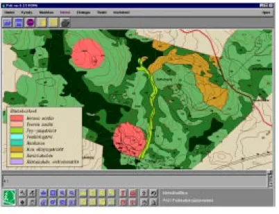
Data on individual stands collected in the census are recorded in a geographic information system (GIS). In field censuses, identified occurrences of endangered species are recorded and their exact location is entered into the geographic information system.
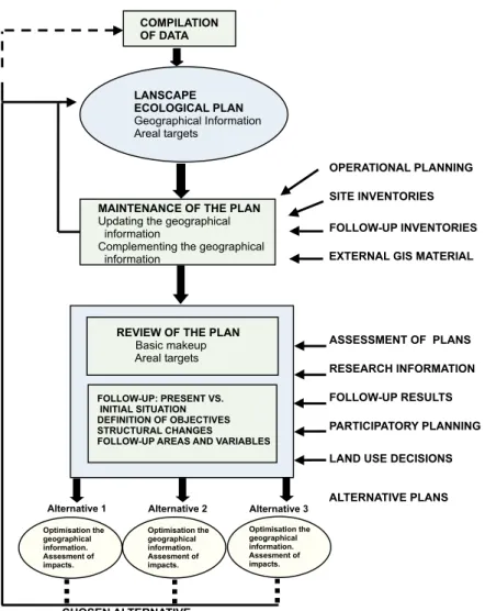
Compiling the plan
Documentation of the plan
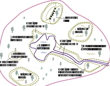
Valuable habitats and occurences of species
The valuable habitats are inventoried and recorded in the geographic information system according to the fieldwork guidelines (Soinne 1999, in Finnish). When selecting valuable habitats, the number and quality of species occurring are taken into account. The presence of species that enjoy special protection under the Nature Conservation Act are identified and always recorded in the geographical information system.
The aim is also to inventory other occurrences of threatened species and record them in the geographic information system. Occurrence of these species is recorded in the geographic information system as required in the conservation plan. Operational guidelines on the nesting areas of birds of prey are provided in the Environmental Guidelines (Metsähallitus 1998).

Ecological links
The nests of other birds of prey (such as the osprey (Pandion haliaetus), the peregrine falcon (Falco peregrinus), the gyrfalcon (Falco rusticolus) and the eagle owl (Bubo bubo)) are recorded either as compartments or as spots in the Geographic Information System. In contrast, pine-dominated forests (moderately dry or nutrient-poor mineral soils) can be regenerated in phases based on an extended rotation time (e.g. 1.7 x the normal rotation time). In ecological corridors consisting of young forests, careful thinning operations can be carried out.
Small-scale measures carried out in forests bordering the ecological network should aim to make the ecological corridors at least partially viable habitats for species that require moist and stable microclimates. The other side of the forest bordering the corridor shall not be regenerated until the dominant height of the plot on the side which was first regenerated has reached at least one third of the dominant height of the plot in the corridor. In the Landscape Ecological Plan, the conservation areas together with valuable habitats and occurrences of species form the core of the ecological network.
Biodiversity enhancement areas
Biodiversity-enhancing areas are formed, for example, in areas where habitats with deciduous trees and dead wood are scarce. In such cases, the forests are treated in such a way that more dead wood is produced than normal. Prescribed burning may also be recommended, which means that the retention trees are also burned.
The biodiversity enhancement area can also be a forest area that was previously managed with the effect of producing an ecologically poor area, such as a young, even-aged pine stand. In such a state, biodiversity and variation can potentially be restored through measures such as minor regeneration cuttings. However, it should be noted that under the Forest Act, regeneration cuttings in growing plots are only possible on sites of special value.
Ecological restoration
Landscape ecological planning can also define areas that can return to their natural state through natural progression, without active restoration measures. Such self-renewing areas may include previously logged riparian forests and drained fertile peatlands of relatively small area.
Use of prescribed burning
Proportion of broadleaves and broadleaf-dominated forests
If no target has been set for the share of deciduous trees, their development should be monitored based on the targets set in the forestry guidelines (Hokajärvi 1997, in Finnish). If the forest is in its natural state, the proportion of deciduous trees can be roughly estimated based on two factors: the ASIO model based on wildfire frequency and the prevailing habitats. In mesic and herb-rich mineral soils, it was estimated that about half of the forests consisted mainly of deciduous trees.
Based on this information, a realistic long-term goal for the future proportion of broadleaf forests in the area should be determined. One of the goals is to maintain or increase the proportion of rare deciduous trees such as aspen, goat willow and rarer species. The number of these should be gradually increased, for example in biodiversity enhancement areas or in ecological networks.
Decaying wood
The target share can, for example, be half of that in forests in their natural state. Young broadleaf forest successional stages in their natural state are important habitats for certain species. The general principles for retaining dead wood in cuttings are given in Environmental Guidelines for Practical Forest Management (Metsähallitus 1998).
The fulfillment of the objectives is monitored by measuring the amount of retained trees and dead wood during felling monitoring. The amount of dead wood has decreased in areas that have long been in commercial use. The aim may be to increase the amount of dead wood, for example by leaving retention trees in the area.
Proportion of old-growth forests
When setting the goal of the proportion of old forest, the aim is to ensure the required proportion in the long term, mainly in existing conservation areas and in areas of special value defined in the plan. These include the ecological network, intact old-growth forest stands and other key biotopes, as well as riparian and scenic forests and other areas with extended rotation times. Depending on the previous use of the forests, it is possible that in conventionally managed forests there is a considerable amount of old forest.
In areas where the proportion of fire refugia and rarely burned forests is significant (categories A and S), the target percentage of old-growth forests (% . of the forest area) should be higher than in other areas in the long term, at least 6-10%. On the other hand, the target percentage for old-growth forests may be lower in areas where most forests have been burned by wildfires (categories I and O), e.g. In areas where the proportion of poorly productive forests is significant, the target percentage can also be lowered accordingly.
Valuable landscapes and cultural sites
The purpose of the analysis is to specify the sites where special attention should be paid to the location and design of forestry operations with a view to scenic values. The areas are treated on the basis of an extended rotation time, but this may include some plots where it is best to refrain from any operations and also plots that can be treated according to normal silvicultural principles. Natural forests in general can be thinned, and the aim is to restore the stands in stages and avoid large areas of regeneration.
If necessary, the stands can be cultivated in two phases, for as long as necessary to ensure forest cover in the area. These include prehistoric human habitations, burial grounds, and other sacred sites and places associated with hunting culture (such as deer pitfalls). The sites are recorded as spots in the geographical information system, but the actual demarcation must be done under the guidance of the National Antiquities Service, whereby the buffer zone and the need for maintenance of the site are also assessed.
Game habitats
The inventory of hazel grouse habitats is also important, because the hazel grouse is very attached to its territory. If necessary, special wildlife management measures or areas can be included in the plan. In certain areas, the focus of forest management activities can also be adjusted so that special attention is paid to game species.
Valuable habitats and ecological corridors also serve as feeding grounds and refuges for certain wildlife species. When selecting valuable habitats, the presence of wildlife habitats in the area increases their value. The plan should assess the impact of the proposed solutions on the game habitats and the general environments for the game species in the area.
Forest roads
Based on the government resolution, the ecological values in these areas will be preserved in relation to commercial use by means of Ecological Landscape Planning (cf. Old-growth Forest Preservation Committee 1996). A key element of good collaboration is effective communication about the plan at different stages of the project. The meeting provides an opportunity to explain the goals of Ecological Landscape Planning and to shed light on opportunities for interest groups, residents and other interested parties to participate in the process.
Questionnaires ask respondents for information about the area and their views on the planning works. Towards the end of the planning project, participants and the general public should be informed of the decisions made and of the completed plan. The process of participatory planning gives people and different interest groups information about the activities of the planning authority and the new methods of forest planning and operation used.
Ecological impacts
Economic impacts
The social impacts can be further assessed based on the number of valuable landscapes and cultural sites specified in the area. The feedback received is summarized and an evaluation is made of the extent to which feedback on the use and management of the area has contributed to the plan. The records and other documents produced in the course of the planning process must also be stored.
The system can therefore be used for monitoring the implementation of the Landscape Ecological Plan. The new data on sites of special value are recorded in the geographic information system. Any changes to the classification of threatened species must also be foreseen in the evaluation of the plans.
Operations are carried out in valuable habitats only with the aim of developing the characteristic features of the area. The details of the operation are planned according to the specifics of the location.