Cultural heritage is conceived as a set of manifestations with the highest aesthetic, historical and social value. Currently, the conditions in the morphological transformation of the landscape are mostly due to economic development and land use.
GENERAL TERRITORIAL PROCESSES: THE GROWING OCCUPATION OF THE ANDALUSIAN
THE BAELO CLAUDIA ARCHEOLOGICAL SITE .1 HISTORIC ANTECEDENTS
LEGAL STATUS
APPREHENDING THE LOCUS- THE TERRITORY 4 METHODOLOGIES
ANALYSIS ANO INTERPRETATION OF GRAPHIC ANO WRITTEN RECORDS
TERRITORIAL INTERPRETATION
TERRITORIAL INTERPRETATION OF THE
SYNTHESIS OF TERRITORIAL UNITS
TERRITORIAL INTERPRETATION: THE INLET OF BOLONIA AS A PILOT STUDY
LANDSCAPE DESCRIPTION ANO ASSESSMENT: THE SCIENTIFIC PROCESS. Methodological outline
VISUAL ANO PERCEPTUAL ASSESSMENT 6.3 LANDSCAPE ANO IMMATERIAL HERITAGE
REFERENTIAL DOCUMENT 6.4.2 PROJECTS
The landscape is interpreted as a dynamic physical manifestation of the complex system of relationships between human activity and the natural environment. 3. To construct a landscape history of archaeological sites by collecting and compiling maps, photographs, oral tradition, and so on.
GENERAL TERRITORIAL PROCESSES: THE OCCUPATION OF THE ANDALUSIAN COAST BY
In the province of Cádiz, any work or activity that tends to change its environment must be reported to the Provincial Urban Planning Commission, which will then request a mandatory report from the Department of Culture of said Junta. The exclusive use of the area must be for culture and recreation or agriculture, as the case may be, with land that can only be cultivated superficially, as long as proof is provided that the materials or structures located on it have not caused damage.
APPREHENDING THE LOCUS- The territory Chance determines fate
It is expressly forbidden to carry out any actions on the foundations, be it excavations or strengthening, for which there is no existing permit from the competent official bodies and the work is not carried out under the guidance of a professionally qualified person. Experimental study of the landscape II. the Arc of Bologna" within the framework of the II. Charter on Territorial Property" is an exceptional opportunity to use the most innovative ideas and approaches that are being developed in the European Union, within the framework of our autonomous community. regarding landscape and policy assessment.
Analytical interpretation
Visual and perceptual assessment 3. Landscape and immaterial heritage
ANALYSIS AND INTERPRETATION OF GRAPHIC AND WRITTEN RECORDS
Perceptions and motives that influence the representation of the sea and mountains - Maps and maps - Strategic location. Literary and epigraphic information complements our knowledge of the city of Baelo and its territory.
Strong coastal dynamics owing to strong winds and ocean currents - Predominance of erosive mechanisms, resulting in exceptional and
To avoid this situation, an interpretive line of reasoning was developed, which avoids inventory and embraces a global interpretation of the area. The study of the relationship between human society and geographical space: use, exploitation, appropriation, affection and individualisation, therefore enables us to influence the relationships between local heritage and development.
Compartmentalized space
TERRITORIAL INTERPRETATION: BOLONIA INLET
A "spatial island"
- DESCRIPTION AND ASSESSMENT OF THE LANDSCAPE: THE SCIENTIFIC PROCESS Methodological outline
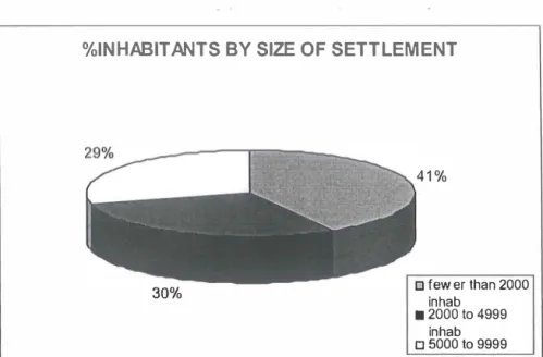
- DESCRIPTION OF THE LANDSCAPE Occupation of surface land: Settlements
- ASSESSMENT OF THE LANDSCAPE
- ASSETS-HAZZARDS
- VISUAL AND PERCEPTUAL ASSESSMENT
- THE LANDSCAPE AND IMMATERIAL HERITAGE
- PROPOSALS: REFERENTIAL DOCUMENT ANO PROJECTS
- REFERENTIAL DOCUMENT
LOCATION: Viewed northeast from San Bartolome Ridge Viewpoint and east from Bolonia Harbor. This contributes to the devaluation of the route by road to the slopes of the Sierra de la Plata.
LANDSCAPE PLANNING
These are the components of the highway's cultural landscape that mark access from the horizon. The project approaches the discussion of the boundaries of the settlement and its interaction with the landscape.
Environmental Planning
Territorial Planning
Sectorial Planning
Tourism Planning
Others
INTRODUCTION
GENERAL OBJECTIVES
Establishing appropriate resources that promote knowledge and respect for the cultural and natural heritage of the area linked to the Archaeological Complex de Baelo Claudia, with the aim of promoting its conservation, especially by the local population. To present lines of research and analysis of the cultural resources designed to ensure the suitability and viability of the social use of the heritage.
UNES AND PROCESSES OF WORK
Theoretical definition: Based on the concept of CULTURAL RESOURCE3 - the entire cultural expression preserved from the past to the present, including as us/1 the places, equipment and agents that influence the current cultural dynamics of the territorial environment - the definition of terms, content and dates that make up the conceptual framework of the project have been tackled. Systematization of the information: The work continued with a general classification of resources distinguishing Heritage Resources, Cultural Equipment and Cultural Agents, followed by the creation of a specific classification of each type to define the dates that had to be collected and analyzed. 34; ali cultural expressions, past or present, tangible or intangible that are representative of the culture of a determined human collective of the past or the present".
34; the cultural resource, understood as that element, place or event, the contemplation of which increases the visitor's perception of the origin, customs and ways of life of the territory visited.
ANAL YSIS OF THE CULTURAL RESOURCES
- SPECIFIC ANAL YSIS OF THE CULTURAL RESOURCES
- ANAL YSIS OF THE CULTURAL RESOURCES' TERRITORIAL SITUATION
- Environmental factors
- Demand
- Supply
- CHARTER OF THE TERRITORY'S VALUES
- DIAGNOSIS
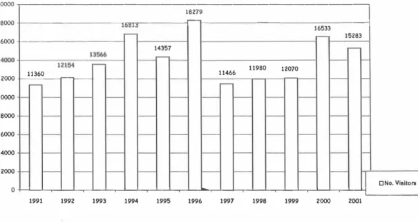
Location of Cultural Resources (Equipment and Heritage Resources of the land properties, Archaeological, Architectural, Ethnological), selected in the territorial frame of the Project "Cultura 2000''. The Analysis of the Situation was based on the concept of study5, visualized in the diagram below In the past three years, the annual number of visitors to the Archaeological Complex has multiplied by 2.5.
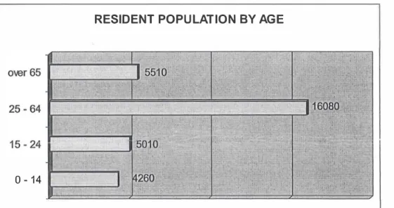
The trees are closely linked to the landscape's evolution; they also play an essential role in the economic development of the area. This may, if it increases in the future, affect the improvement of the archaeological site. This is evident in the distribution of the local population and the way they make a living.

Variation in visits throughout 2001
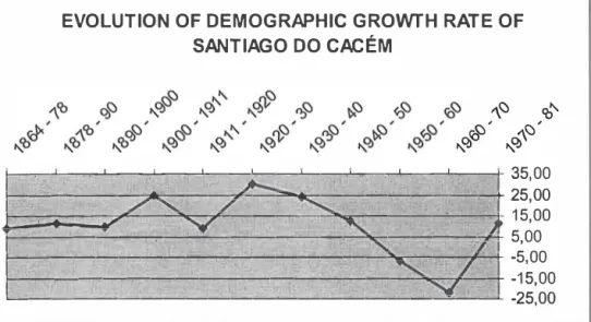
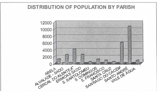
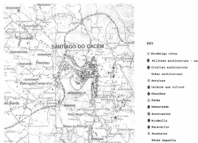
These three components form the basis of the natural resources in Santiago do Cacém and the surrounding area. We mark the beginning of the historical and urban development of the city and have the military component. The urban and architectural component attempted to individualize some aspects of the city's development.
The service component was intended to include other forms of services that contributed to the development of the city. In the religious component, the hats are a symbol of the importance of religion in rural life.
Territorial Framing
In the beginning, some of the water of the Amo flowed onto the plain of Arezzo. From 1388 they ordered the digging of a drain to collect the water of the swamp and drain it to the Amo. The water of the territory of Cortona flows in two opposite directions, separated by a mountain range.
Only the streams on the south side are important in terms of sand, as they collect the water of the wide basin. In the hills of Sepoltaglia and Val d'Esse we find small pine forests.
History of Cortona
At the end of the Republic it was owned by the Perugia family of the Vibii Pansae. But in 1258 the people of Arezzo, with the help of the Guelphs of Cortona, occupied Cortona, sacked it and burned its houses. In 1261, with the help of the Sienese and led by Uguccio Casali, the refugees from Cortona re-entered Cortona through the Porta Bacarelli and took the city by storm from the people of Arezzo.
From 1325 to 1409, Cortona was ruled by the Casali family, who linked their name to the construction of the Palazzo of the same name. Under the command of the Lorraine family in the Grand Duchy of Tuscany, major public works and infrastructures were constructed in Valdichiana.
Historical Documentation Historical Cartography
One of its meritorious actions was the presentation of various works, among them the translation of the famous Encyclopaedia of Diderot, edited by Filippo Venuti. In the following century, the inhabitants of the territory of Cortona participated in the Risorgimento uprisings, and in the referendum of March 1860 they voted for the annexation of the Grand Duchy of Tuscany to the reign of Vittorio Emanuele 11. The Lstituto Geografico Militare di Firenze has made available to us an important aerial photographic documentation of the territory of Cortona.
The most important aerial photographs for the study of the archaeological areas considered are the photograms recorded from the flights taken in 1941, which allow a visualization of the comparison data with the situation on the territory in the current years. The documentation has been completed with a series of aerial photos taken from the flights in the 80's and 90's which show a comprehensive view of the areas taking into account the current time.
Resources of the Territory
Age range Children/Youngsters Adults Elderly
Do you know exactly what constitutes the archaeological property of the municipality of Cortona, that which has been discovered so far? Do you think that the archaeological park can contribute to the protection of the environment? Do you want to participate in the activities related to the Archaeological Park of Cortona, which is considered a guardian of the environment and possibly includes.
The territory of the municipality of Cortona includes a large architectural, archaeological and artistic heritage (picture. The funds of the municipality will be included in the share of the hamlet of Fratticiola.
LIST OF CONTENTS THE ARCHAEOLOGICAL PARK
for the realization of the Archaeological Park, including the funerary monuments of the Cortonese hill and plain. 1 provides for the readjustment of the system of the archaeological heritage which is partly inaccessible today. Retrofitting and safety works of the infrastructure/ network in the Soda area Total amount of the extract.
Purpose: program agreement for the realization of the necessary interventions for the creation of an archaeological park in the municipality of Cortona called '11 Sodo'. Purpose: call for the service conference to examine the preliminary project in the archaeological park.
ARCHAEOLOGY AS SEEN BY THE ARTISTS
Here, children and young people from all types of schools and adults can enjoy educational activities about the park and Cortona's cultural heritage. The park will have information points along all routes, signs with directions and information, a website and a bookshop with guides, depliants and posters.
PROMOTION STRATEGIES FOR THE PARK
Presentation in the schools of the work of the European project 'Workshop of the Lansdcape'. In the mid-14th century there appears to have been a settlement within the Citadel. Headquarters of the Thessaloniki Ephoreia installed in the former Prison buildings properly restored and organized.
Conservation of the existing retaining walls of the gardens, water tank and fountain. Technical coordinator of the program, responsible for the study of urban planning of the location.