PRELIMINARY RISK ANALYSIS OF CLIMATE CHANGE IN THE COAST
OF TAPACHULA MUNICIPALITY, CHIAPAS, MEXICO
—
Vicente Castro Castro [email protected]
Faculty of Agricultural Sciences, Universidad Autónoma de Chiapas, México
— Abstract—
Climat changes that are currently being experimented have started to be of the highest concern and worldwide attention. The effects of climate changes are, among others, the increase of the sea level, the frequency and intensity of hurricanes and extreme wave events, this last effect would mean for the cities that are located on the coast to be in a high vulnerability condition.
Chiapas has been identified as one of the most affected states due to the increase of the sea level. In this work, a preliminary analysis of the coast hazard level of the beaches of Tapachula is carried out, analysis based on the future estimates of the increase of the environmental temperature and the increase of the sea level as well as of the extreme events. For the analysis,
‘’The Coastal Hazard Wheel’’ method was applied and a documental analysis of the extreme events and the damages that were produced in the last five years was also carried out. It was found critic, that one of the two analyzed areas is located in a high level of hazard, in the present time as well as in the future, it means that it is time to take some actions, knowledge-based, that would allow to protect the community patrimony and heritage, but most importantly the personal security as well as the tourists that visit the beaches on the area. It is urgent to examine and take into account the studies done these days as well as to generate new information for the effects of planning and management of the beaches of Tapachula, Chiapas, by means of an integrated management approach to the coastal zone.
Keywords
Coastal hazard analysis, coastal erosion, global warming, integrated coastal zone management.
To quote this article:
Castro-Castro, Vicente. (2018) Análisis preliminar de riesgo por cambio climático en la costa del municipio de Tapachula, Chiapas, México. Espacio I+D Innovación más Desarrollo, 7(18) 92-116. Recuperado de: http://dx.doi.org/10.31644/IMASD.7.2018.a05
T
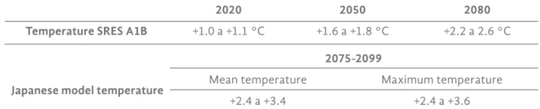
he climate changes that are currently experienced worldwide are already of the highest concern and attention everywhere. In this context, global warming looms as one of the greatest future threats for the world population as it is expected, among other changes, an increase in the levels of droughts, increase in the frequency and intensity of storms and hurricanes, an increase in the average sea level, as well as an increase in extreme events such as the sea bottom.The increase in the environmental temperature is a reality that is analyzed at national and state level. In Mexico, mainly for the northern states, it is estimated that the increase in temperature between 2020 and 2080 can be between 2 to 4°C, while the increase in the surface temperature of the Caribbean Sea, Gulf of Mexico and Pacific Ocean is estimated in the order of between 1 and 1.5°C (National Institute of Ecology [ine], 2006). For the State of Chiapas, the scenarios of expected increase in the environmental temperature can be observed in Table 1.
Table 1. Environmental temperature scenarios for the state of Chiapas
2020 2050 2080
Temperature SRES A1B +1.0 a +1.1 °C +1.6 a +1.8 °C +2.2 a 2.6 °C 2075-2099
Japanese model temperature Mean temperature Maximum temperature
+2.4 a +3.4 +2.4 a +3.6
Source: Table prepared with information of the project "Climate scenarios for the state of Chiapas. Final report phase II (UNICACH, 2010)
Given the rise in environmental temperature, one of the main expected effects is the increase in the mean sea level (Grinsted et al., 2009), an effect mainly explained by thermal expansion and ice melting (Meehl et al., 2007). According to Vázquez-Botello (2008) the most affected states in Mexico, before the increase of one meter in the sea level, will be Campeche, Chiapas, Nayarit, Oaxaca, Quintana Roo, Sinaloa, Tabasco, Tamaulipas, Veracruz and Yucatan (Image 1).
The increase in the mean sea level will result in an increase in the depth of the water column, which will lead to a decrease in the friction of the bottom and increase the energy of the waves (Vázquez-Botello, 2008). This will lead to more intense processes of beach erosion and, consequently, damage to the coastal infrastructure as well as private properties and risks for bathers, which will also intensify in the face of events such as hurricanes and deep sea.
Image 1. Affected areas of Mexico. In red, the areas that will be affected by the 1 m increase in the mean sea level for Mexico are shown.
The white circle shows the coast of Chiapas
Source: Environmental Research Laboratory, University of Arizona
Given the future scenario and its potential effects, it is urgent to assess the risk levels of the coast in those entities where greater damages are expected such as the coast of Chiapas. In this sense, a preliminary coastal risk analysis was carried out in the municipality of Tapachula, the result of this analysis was subject to ratification or rejection based on the changes and/or damages documented in the coast of Tapachula, Chiapas in recent years. The analysis should be a tool that allows to contribute and promote an integrated management program of the coastal zone (mizc) of the municipality of Tapachula in particular, and the state of Chiapas in general, to safeguard the coastal infrastructure, but even more, in the protection of the inhabitants of the coast and the visitors of the beaches.
METHODS The coast of Tapachula
The municipality of Tapachula is located in the southern portion of the state of Chiapas (Image 2) and has a coastline extension of around 21 km, of which just over 3.1 km correspond to the urban area of the Puerto Madero community, which is protected from the sea by an artificial stone wall and concrete blocks (Castro-Castro and Barrios-Ramos, 2009).
The coast of Tapachula belongs to the great marine ecosystem of the Central American coast of the Pacific, which is an open ecosystem with an oceanic limit established by the continental shelf (Escofet, 2009). Its origin is a collision of plates (De la Lanza, Ortíz-Pérez and Carbajal-Pérez, 2012).
According to Ortiz and de Lanza Espino (2006) the area of interest is located in the southern region of the Mexican Pacific which is characterized by extensive sandy beaches, mostly of coarse and medium texture, with slopes commonly greater than 12 ° and they present distant waves of high energy coming from the south. The coast of Chiapas belongs to the coastal unit IX, with a coastal plain in development of moderate amplitude and with a wide continental shelf (Carranza-Edwards, Gutiérrez and Rodríguez, 1975). In the area of interest there are two climates, in the northwestern portion there is a warm sub-humid climate with rain in summer, with higher humidity, A (w2); while in the southeastern portion the climate is warm sub-humid with rain in summer, of medium humidity, A (w1); the dominant soils of the area are thick eutric regosol (Re/1) (inegi, 2006).
Image 2. Work areas. The coastline of the municipality of Tapachula, Chiapas is shown. a = beach erosion zone, b = beach accretion zone
According to the Mexican Geological Service ([sgm], 2012) and Barrios- Ramos (2013) on the coast of Tapachula, there are two distinct areas, an area a of intense erosion that is located on the north-west of the breakwaters built in the 70's and that has affected homes and restaurants in the community of Puerto Madero, and an accretion zone b located southeast of the breakwater
mentioned above (Image 3). Based on this differentiation, the analysis was based on said zoning (Image 2).
Image 3. Breakwaters built in the 70's. The changes in the coastline are presented at both ends of the built breakwaters
that separate the two study areas
Source: Barrios-Ramos (2013)
Preliminary Risk Analysis
Based on the available scientific and climatological information, a preliminary analysis of the coastal risk level of Tapachula, Chiapas was conducted for the two indicated areas and applying "The Coastal Hazard Wheel (chw)"
(Rosendahl and Halsnæs, 2015) (Image 4), which is a simple technology tool that can be used in areas with limited data availability and institutional capacity, is, therefore, specially made for use in developing countries. The method first performs a classification of the coast, then identifies the level of inherent risk (low, moderate, high and very high) that is established under a climate change scenario in five biogeophysical properties of the coast (Rosendahl and Halsnæs, 2015):
a) Ecosystem disruption: describes the possibility of an interruption of the current state of the coastal ecosystem under a climate change.
b) Gradual inundation: describes the possibility of a gradual submersion of a coastal environment under climate change.
c) Salt water intrusion: describes the possibility that marine salt water penetrates into shallow coastal waters and groundwater aquifers under climate change.
d) Erosion: describes the possibility of erosion of a coastal environment under climate change.
e) Flooding: describes the possibility of a sudden, abrupt and often dramatic flooding of a coastal environment caused by a short-term increase in water level due to storm surge and extreme tides under climate change.
The level of coastal risk obtained was validated from the changes and/or damages documented by various studies and by recent (2015) environmental phenomena (sea bottom) that modify and generate disasters in the coastline.
Image 4. Coastal risk wheel. Proposal used to assign the level of risk of the areas of interest (Rosendahl and Halsnæs, 2015)
RESULTS
From the available information
When carrying out the search and analysis of the existing information it was possible to confirm that this is scarce; however, it was sufficient for the objectives of this work. Of the works carried out to date, the following stand out:
a. Coastal dynamics study and wave measurement to solve the problem of clogging of the access channel of Puerto Madero, Chiapas (Mexican Institute of Transportation [imt], 1997). Data on erosion and accretion were reported, on the protection structures, sediment transport, variations of the coastline, and beach profiles among others.
b. Analysis of the erosion/accretion process in Puerto Chiapas, Mexico (Bustamante, 2007). This work made short and long term scenarios on coastal morphology, in addition to proposing solutions to erosion/sedimentation.
c. Changes in the coastline of the municipality of Tapachula, Chiapas, Mexico (Barrios-Ramos, 2013). The study reports the short and long term changes that the Tapachula coastline has suffered, as well as documenting erosion, describing the beach profile, as well as the types of sand on different beaches.
d. Atlas of hazards of the State of Chiapas. Technical report (sgm, 2012). This document describes the erosion/sedimentation processes that occur in the coastline; however, it does not establish any level of danger or risk.
e. Loss of beaches in Puerto Madero, Chiapas. Damages and perspectives (Castro-Castro et al., 2015). This work analyzes the loss of beaches, its consequences and the anthropic and natural factors that cause the erosion of the beaches of Tapachula, Chiapas.
f. Erosion and sedimentation of beaches in the municipality of Tapachula, Chiapas, Mexico (Castro-Castro et al., 2017). The study documents short and long term changes of the coastline of Tapachula, Chiapas; In addition, it describes, from the coastal sedimentation erosion index, the current state of the beaches, and performs a granulometric analysis of the same.
Preliminary risk analysis; stage 1, classification of the coast
Based on the existing information, the preliminary coastal risk analysis was carried out for the two well-defined zones of Image 2. Thus, the characterization of zone a was:
* Geological arrangement: sedimentary plain ( ), coast with slope less than 3-4%, at least 200 meters inland from the middle tide line, are composed of sedimentary deposits of silt, clay, sand, gravel or large pebbles.
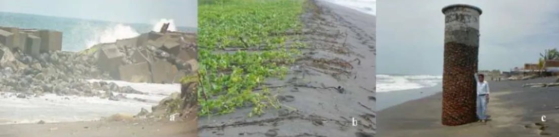
* Wave exposure: originally the area was totally exposed to the waves ( ), to date about 50% of the area is exposed to waves ( ) and 50%
protected ( ) by a barrier of stones and concrete blocks (Image 5a).
* Tidal range: micro-tidal ( ) in normal climatic conditions (without storms, sea bottom or hurricanes), where the tidal range (vertical difference between high tide and low tide) is less than 2 meters.
* Flora/Fauna: it does not have a relevant role in the characteristics of the coast ( ) and/or in the inherent risk profile, this because 50% of this area is protected by an artificial barrier of rocks and concrete blocks (Image 5a) and the remaining 50% presents mostly herbaceous vegetation (Image 5b) that very little contributes to the stabilization of the coast against the force of the waves.
* Sedimentary balance: although the sedimentary dynamics of this area, according to the methodology used, is located in the balanced/
deficit category ( ), the reality is that this area is totally deficient, since it is a highly eroded zone (Image 5c).
* Storm climate: the zone is of high tropical cyclonic activity ( ).
Image 5. Evidence of the characteristics of the area a. Image shows the barrier of artificial protection of rocks and concrete blocks; image b shows
herbaceous vegetation and image c the level of erosion
Zone b presented characteristics similar to zone a with the exception of the sedimentary balance, since in this zone the sedimentary dynamics was surplus according to the literature reviewed, so the beach has increased considerably.
Preliminary risk analysis: stage 2, level of inherent risk
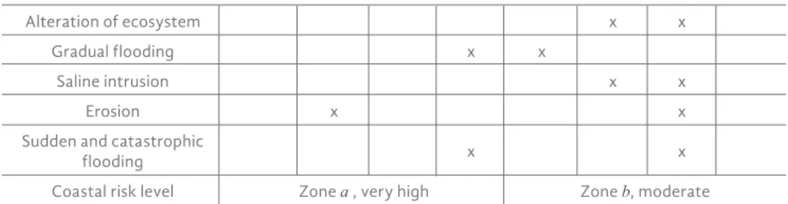
The second stage of the methodology employed leads to determine the level of inherent risk defined as the risk that exists in the inherent part of the biogeophysical properties of a coastal environment, when exposed to predictions of changes in the global climate of the coming decades (Intergovernmental Panel Climate Changes [ipcc], 2007, 2013). Although the level of risk posed by the chw method is under a future climate change scenario, it can also be applied to current conditions, so the exercise was carried out in the current and future scenario. The results of the current risk analysis of zone a and zone b are presented in Table 2.
Table 2. Current coastal risk level of the sites analyzed
Intrinsic risk level
Low (1) Moderate (2) High (3) Very High (4)
Biogeophysical properties ɑ b ɑ b ɑ b ɑ b
Alteration of ecosystem x x
Gradual flooding x x
Saline intrusion x x
Erosion x x
Sudden and catastrophic
flooding x x
Coastal risk level Zone ɑ , very high Zone b, moderate
The analysis carried out has taken into account the changes suffered in the coast of Tapachula in the last 10 years, and recent events of the sea bottom.
Thus, the considerations made by biophysical property were:
Alteration of the ecosystem: the whole landscape of the beach, to the west of the breakwaters (zone a) built in the 70's, has been completely modified for the protection of the community of Puerto Madero with a stone barrier and concrete cubes (Images 5a, 6). This alteration has continued during the last years with the construction of new protection structures (Images 7), which undoubtedly is a very strong alteration of the beach ecosystem, which is why it was classified as very high risk.
Image 6. Breakwater and wall. It shows the breakwater built in the 70's (including extensions made in recent years) and the barrier of concrete cubes
Image 7. New works of "protection". The new "protection" works constructed in recent years in the west of the community of Puerto
Madero, Tapachula, Chiapas, are shown in a circle
With regard to zone b, the alteration of the ecosystem has also occurred strongly, but due to intense accretion processes of the beach. The accretion processes have been considered, from the tourist perspective (AC National Academy of Research and Development [anide], 2018), as a process that contributes to reducing the vulnerability of beaches, so that the level of risk for the zone b was established low.
Gradual flooding: for zone a, a high risk level was considered because the area is a storm climate and during the rainy and cyclones season; floods in
the community usually occur. For zone b, because it is a sparsely populated area (mainly resting houses), and with a wide beach, the risk level of gradual flooding was estimated to be moderate.
Saline intrusion: in conversations held with inhabitants of the Puerto Madero community, it was verified that salt water has been introduced around 60 to 100 meters into the continent, while in the low season the saline intrusion expands around 120 -150 meters to the continent, so this area was classified as very high risk. While for zone b, due to the amplitude of the beach, it was placed at moderate risk level.
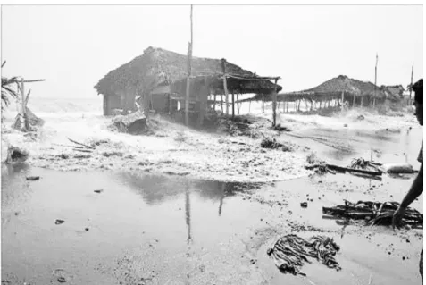
Erosion: in terms of the erosion of the beaches analyzed, the evidence was overwhelming, zone a has suffered for more than 20 years severe erosion processes (Images 5c and 8), a process that continues today and has generated serious damage to tourism infrastructure and family heritage, so that the current level of risk was identified very high as can be seen in Image 8. For zone b the beach has had a progradation process, registering areas where the beach has grown little more than 800 meters (Image 9), which is why the area was at a low risk level.
Image 8. Erosion and damage in zone a. Severe erosion and damage to the touristic infrastructure and family heritage in Puerto Madero, Tapachula,
Chiapas are shown. Images of September 2012
Image 9. Accretion of beaches. Part of zone b is shown. The black lines show the length of beach that has been acquired. a=830 m, b=673 m
Sudden and catastrophic flooding: this biophysical characteristic is perhaps the highest risk due to the sudden condition. In recent years there has been an increase in bottom-sea events, which have mostly been unexpected for the population of Puerto Madero and have caused major damage to the tourist infrastructure (Image 10). In the year 2015, three sea-bottom events were presented (April, May and August), the one happening in May being the most catastrophic one (Image 10), where according to the Meteorological Bulletin of the Dirección General Adjunta de Protección y Seguridad Marítima de la Secretaría de Comunicaciones y Transportes, the predicted waves reached heights greater than 2.1 m. To date, these sea-bottom events are occasional, so the level of risk assigned to this area was high. For zone b, given the width of the beach, the sea bottom has caused minimal damage, so the level of risk assigned was moderate.
There is no doubt about the existing evidence that zone a is an area of very high risk, since when estimating the average value, according to the chw, it was 3.6, while for zone b, the average value was 1.6 , which places this area with a moderate level of risk. The status of zone a with a very high level of coastal risk requires urgent attention from the authorities of the three levels of government, as well as from research institutions and society in general.
Future scenario through chw
The CHW is a developed system of multi-risk assessment and multi-risk management of coastal areas under a scenario of climate change for decades
to come, and can be applied at a local, regional and national level (Rosendahl and Halsnæs, 2015). For the zones that are presented, it is important to mention that the analysis scenario was projected towards the closest temperature increase (Table 1) (2020; + 1.0 °C to + 1.1 °C), and the scenario of the highest temperature increase (2075-2099; + 2.4 °C to + 3.6 °C). In all cases, several documents conclude that the consequences of this increase in the environmental temperature will be a greater number of hurricanes per year and of greater intensity; as well as an increase in the mean sea level.
Consequently, the expected risk analysis is presented in Table 3.
Image 10. Groundswell. Impact by sea bottom in Puerto Madero, Tapachula, Chiapas in May 2015
The average risk level for the zone a went from 3.6 to 3.8, while for zone b the change was from 1.6 to 2.2, although both zones increased their average risk value, the level of assigned risk remained in very high level of risk for zone a and moderate level of risk for zone b. The very high level of coastal risk in the zone a, current and future requires immediate attention.
Table 3. Expected risk level
Intrinsic risk level
Low (1) Moderate (2) High (3) Very high (4)
Biogeophysical properties ɑ b ɑ b ɑ b ɑ b
Alteration of ecosystem x x
Gradual flooding x x
Saline intrusion x x
Erosion x x
Sudden and catastrophic
flooding x x
Coastal risk level Zone ɑ , very high Zone b, moderate
DISCUSSION About the sea level rise
For the Mexican Pacific coasts (excluding Acapulco, Guerrero) of which there is a registry (Ensenada, BC.; La Paz, BCS.; San Carlos, BCS.; Guaymas, Son.; Topolobampo, Sin.; Mazatlan, Sin.; Manzanillo, Col.; Puerto Angel, Oax.; and Salina Cruz, Oax.), trends have marked increases between 1.04 and 16.08 mm/year for the time period from 1951-1968 to 1987-1992. In the case of Puerto Madero, a rough approximation made by Castro-Castro et al.
(2015) states that the sea level rise per year is 1.70 mm/year, a value very similar to those reported in Puerto Angel and Salina Cruz, Oaxaca of 1.70 and 1.13 respectively (Vázquez-Botello, 2008).
In the future there are several estimates regarding the sea level rise at a global perspective. The ipcc (2007) and Rahmstorf (2007) estimated that by 2100 (relative to 1990) the mean sea level will rise between 18 cm to 1.4 m.
For the Gulf of Tehuantepec, including the coast of Chiapas, the approxima- tions of the mean sea level rise, for the period 2010-2040, are between 1.8 to 2.0 mm / year, and for the period 2040-2070 are between 2.0 to 2.4 mm / year (United Nations [un], 2015), which implies that from 2010 to 2070 the average sea level could rise between 114 mm to 132 mm. It is important to consider that numerical models give us estimates based on available data, which in many cases are insufficient, and expected data where uncertainty is high, so that approximations of increase must always be considered with due precautions and considering the uncertainty associated (Table 4). It is also advisable, for the protection of people, the coastal infrastructure, the assets of individuals and companies, to always consider the most dangerous scenario so the protection measures implemented are as efficient as possible, to ensure the greater security of society as a whole.
Table 4. Sea level expected rise and associated uncertainty (95% confidence) for the Gulf of Tehuantepec
2040 2070 Expected average value (mm) 43.5 a 54.4 96.5 a 119.4
Associated uncertainty (mm) 2.2 a 3.5 7.1 a 8.2
Source: Chart made with UN data (2015)
With the rise in mean sea level it is expected that floods, storm surges, coastal erosion, salinization of the water table aggravate, this last one will decrease the availability of water for humans and the ecosystems of coastal areas. The rise in sea level will increase the water column, decreasing bottom friction, inducing higher energy waves in the coastline (Vázquez- Botello, 2008), and therefore, coastal erosion and potential damage to the coastal infrastructure and heritage of the people, in addition to the increased risk in the lives of people.
About the coastal risk level
Although the coastal risk level used here is based on the risk that exists in the biogeophysical properties of a coastal environment, when it is exposed to predictions of changes in the global climate of the coming decades, it is clear that its implications go beyond the biogeophysical characteristics, and necessarily involve socioeconomic (Puerto Chiapas, port area bordering the community of Puerto Madero, has been declared as Special Economic Zone, which enhances the risk analysis from an economic perspective), environmental and disaster aspects, such as watershed management, beach dynamics, changes in land use, protected natural areas, urban and rural development, salinization of the water table (decrease in the availability of water for human use and consumption), analysis and prevention of risks among many others.
In the case of zone a, the result was overwhelming both in current and future time, a very high coastal risk level. This level of risk was assigned since it was clearly and strongly evidenced that the original biophysical conditions of the zone a coast have been strongly altered and above all the processes of beach erosion have been and still are intense (Images 5c and 8), besides alteration of the ecosystem of beaches and the saline intrusion.
It should also be noted that in recent years, extreme events such as the sea bottom have been presented with greater frequency and intensity (Image 10).
It is indisputable that the very high coastal risk level assigned to zone a leads to another concept that is duly relevant to the scenario posed in this area: the concept of Vulnerability. According to the ipcc (2001)
vulnerability is the "Measure in which a system is capable or unable to cope with the negative effects of climate change, including climate variability and extreme events. Vulnerability depends on the character, magnitude and rate of climatic variation to which a system is exposed, its sensitivity and its ability to adapt.” Vulnerability refers to three key components: a) exposure, which refers to the degree to which a system is exposed to external stimuli acting on it; b) sensitivity, refers to the rapidity of reaction, that is, to the degree of affectation and change (positive or negative) of the system in the face of climate change or any of its components, and c) adaptability, referred to the capacity or ability of a system to adjust to changes, in the sense of being better prepared to face and manage their "exposure" and
"sensitivity" (Department of the Environment, Junta de Andalucía [cmaja], 2011). When working with exposure + sensitivity, gross vulnerability is described, and when working with the three components, net vulnerability is described (cmaja, 2011).
Under the previously described vulnerability approach, it is clear that zone a is highly exposed to external events, and it is also highly affected, in a negative way, to these stimuli, so it is highly feasible to consider this area with a very high level of gross coastal vulnerability; however, it is important to perform the analysis with the necessary details. It is also very likely that the net coastal vulnerability will be very high, since the evidence of damage and changes in the coastline does not allow us to consider that the area has a good capacity to adapt or adjust to changes.
Additionally, it is important to consider the occupation and urbanization of the coastal areas in an unplanned manner in these risk and vulnerability analyzes, since they generally do not respect the existing norms and laws regarding the use of land, modification and/or destruction of the coastal natural protections, such as mangrove forests and coastal dunes among others, and that alter the dynamics of coastal biophysical processes that consequently increase the natural fragility of the territory where social activities take place and therefore potentiate the negative effects on the community and their assets (Monti and Escofet, 2008; Cabrera et al., 2009), as is the case of the community of Puerto Madero (Image 11) where the anthropogenic and natural damage suffered has led to the realization of multiple works of "protection" (breakwaters), works that contributed to the erosion and loss of beaches, which unquestionably affected the ecological balance of beaches; as well as the loss of houses, palapas and restaurants. In this context, the integrated management of the coastal zone is the fundamental tool, where the reduction of risks and disasters, have been analyzed as elements and actions that allow to prevent and minimize threats and
vulnerabilities (mitigate) that allow to give notice and if necessary evacuate the population during the occurrence of a disaster (alert), it is also included in this context save, assist and defend the population and their goods (respond), to finally proceed to the correction of damages (reconstruction) (Ramírez- Chávez, 2010).
Image 11. Madero Port. The barrier of stones and concrete blocks that protect the community are shown in black. The circles show areas where
the stone barrier has disappeared
In the case of zone a, given the very high level of coastal risk, the high level of vulnerability and the evidence of damage to the community and its assets (Images 8 and 10), it is urgent to start working under the vision of a mizc that allows, as soon as possible, planning and ordering the coastline of the municipality of Tapachula (including zone b), with the objective of making a sustainable management of the coast, as well as preventing risks and minimizing damages for the benefit of society.
CONCLUSION
It is clear that the coast of Tapachula has two very different areas. However, given the current and future scenario, it is zone a that has been identified in this work as a zone of very high level of coastal risk and vulnerability, which consequently has placed and places society and its goods in conditions of high danger, which requires urgent attention in a context of adaptive integrated management.
PROPOSALS
As an indispensable and urgent policy, it is proposed to initiate efforts to develop an adaptive integrated management program for the coastal area of Tapachula and the entire coast of Chiapas, which involves the aspects discussed here of coastal risk and coastal vulnerability, which it also involves the prevention and mitigation of risks in the event of disasters, as well as the consequent reconstruction if necessary. It must also necessarily involve the management and conservation of biotic and abiotic natural resources.
Another suggestion that could and should be implemented, in those areas where it is not yet urbanized, is the zonation proposed by Barrios and Castro-Castro (2013) consisting of (Image 12):
a) Active zone: the intertidal zone, up to the waves of greater intensity reach limit, preferably registered in hurricane seasons;
b) Buffer zone: area where the 20 m corresponding to the federal zone described in the General Law of National Assets must be applied. This area can be concessioned, but it is suggested that fixed infrastructure is not allowed, only movable accessories such as sun chairs and sunshades and therefore it is the ideal area for visitors to temporarily settle to enjoy the beach;
c) Service area: an area with at least 20m in width and that must be an area also owned by the Mexican state and, if applicable, concessioned to individuals. In this area it is suggested to install non-fixed infrastructure (rustic palapas, portable stores, drinks and sweets kiosks among others); and
d) security zone: zone from which it is already possible, with the corresponding environmental precautions (analysis of environmental risk and long-term analysis of the dynamics of the beach) the installation of fixed infrastructure (restaurants, houses, warehouses, among others), from this point, it is possible to have a greater guarantee in the security of the infrastructure, therefore a lower probability of economic loss.
Image 12. Zoning proposal Barrios and Castro-Castro (2013), propose four different zones for the beaches of Puerto Madero, Tapachula,
Chiapas. Image taken from the aforementioned authors
Even when it is necessary to carry out the necessary studies, another proposal that must be considered are wave energy dissipaters such as artificial reefs, sunken ships or submerged stone structures and/or blocks of concrete that reduce the force of the waves that reach the beach (Image 13).
Image 13. Wave energy sink. It shows a submerged structure that allows to dissipate the strength of the waves
Source: presentation of the Universidad de Coruña and Enxeñaría de Auga e do Medio Ambiente in Xornada on enerxía que vén do mar.
It is also urgent to increase the scientific research that allows updating the existing information and generating the one that is essential for a program of integral management of the coastal zone. Investigation in sediment dynamics, currents, erosion and protection of beaches, accretion of beaches, environmental and socioeconomic impact, strategies of restoration and protection of natural resources, protection of coastal infrastructure among many other areas, information that allows decision-making based on knowledge, with the ability to adapt to the changes that arise, for the benefit of society in general present and future, that is, a program of coastal management intra and interdisciplinary, multi-sectorial, transversal and adaptive.
Citizen participation is essential, particularly for the inhabitants of Puerto Madero, who must be the main managers for the protection of their assets, but above all for the protection of themselves; besides being the first plaintiffs and protagonists of diverse actions like reforestation of the littoral zone, active participants in the decision making of future works of "protection"
and "development" of the community, citizen training for management and decision making, demand of officials from the three levels of government with apt skills and competencies for coastal management.
Undoubtedly, this last characteristic is urgent and fundamental, since both the coastal municipalities and the state government do not have personnel to meet the needs of the Chiapas coast, even when they have clear faculties in the different legal systems; while the unit of coastal ecosystems of the Federal Delegation of semarnat in Chiapas is too limited to cover the entire Chiapas coast. The aforementioned marks urgently that decision-makers in coastal management, mainly at the state and municipal levels, have the ideal profile, or at least be properly trained in coastal management, a skill that allows them to make the appropriate decisions that allow development and sustainable use of the coastal zone of Tapachula and Chiapas.
Thanks:
Angélica Córdoba for the support in translating the abstract.
QUOTED LITERATURE
anide. (2018). Estudio de la vulnerabilidad y programa de adaptación ante la variabilidad climática y el cambio climático en diez destinos turísti- cos estratégicos, así como propuesta de un sistema de alerta temprana a eventos hidrometeorológicos extremos. Sección IX. Vulnerabilidad del destino turístico Veracruz. anide/sectur/cestur/conacyt. Proyecto clave: 165452. 39 p.
Barrios-Ramos, M. A. (2013). Cambios en la línea de costa del municipio de Tapachula, Chiapas, México. Tesis de Licenciatura de Ingeniero en Sistemas Costeros, CenBio, unach. 29 p.
Barrios, R. M. A. y Castro-Castro, V. (2013). Zonificación de playas: Propuesta para playas del municipio de Tapachula, Chiapas, México. 73-75. En:
Memorias de ponencias del 6º. Congreso de Investigación unach 2013. 5-6 de diciembre del 2013. Tuxtla Gutiérrez, Chiapas. 847 p.
Bustamante, I. F. (2007). Analysis of the erosion/accretion process in Puerto Chiapas, México. Master of Science Thesis. unesco-ihe. 160 p.
Cabrera, J. A., Alcántara-Carrió, J., Correa, I. D., Pérez de los Reyes, R., Moya, B. V. y Morales, M. (2009). Gestión de Playas. En: Alcántara, C. J., Correa-Arango, I. D., Isla-Mendy, F. I., Alvarado-Ortega, M., Klein, A. H. F., Cabrera-Hernández, A. y Sandoval-Barlow, R. (Eds) Métodos en Teledetección Aplicada a la Prevención de Riesgos Naturales en el Litoral. Madrid, España: Servicio de Publicaciones del Programa Iberoamericano de Ciencia y Tecnología para el Desarrollo. 297 p.
Carranza-Edwards, A., Gutiérrez, E. M. y Rodríguez, T. R. (1975). Morfo- tectónicas continentales de las costas mexicanas. Anales del Centro de Ciencias del Mar y Limnología; Vol. 2, Núm. 1.
Castro-Castro, V. y Barrios, R. M. A. (2009). Avances en la caracterización de la línea de costa del municipio de Tapachula. Bases para su conserva- ción y manejo. 242-244. En: Escamirosa, M. L. F., López, G. A., Escobar, M. I. H., Reyes, L. B. O., Pérez, A. E. J. y Gil, D. M. (Eds.). Memorias del 2º. Congreso de Investigación unach 2009. unach. 28-30 octubre del 2009. Tapachula, Chiapas.
Castro-Castro, V., Barrios-Ramos, M. A. y López-Urbina, J. H. 2015. Pérdida de playas en Puerto Madero, Chiapas. Daños y Perspectivas. 45-68. En:
Trujillo-Olivera, L. E. (Compiladora). Salud y políticas públicas: magnos acuerdos, acciones limitadas. unach. 330 p.
Castro-Castro, V., Barrios-Ramos, M. A., López, U. J. H., Fierro, M. M. M.
y Díaz, V. J. (2017). Erosión y sedimentación de playas del municipio de Tapachula, Chiapas, México. 133-155. En: Balocchi, F. y Chreties, C.
Procesos de erosión sedimentación en cauces y cuencas Volumen 3. phi - viii / Documento técnico Nº 38. unesco. Montevideo. 155 p.
cmaja. (2011). Análisis preliminar de la vulnerabilidad de la costa de Andalucía a la potencial subida del nivel del mar asociada al cambio climático. cmaja/
Unión Europea/Universidad de Sevilla. 151 p.
De la Lanza, E., Ortiz-Pérez, M. A. y Carbajal-Pérez, J. L. (2012).
Diferenciación hidrogeomorfológica de los ambientes costeros del Pacífico, del Golfo de México y del Mar Caribe. Investigaciones Geográficas, Boletín del Instituto de Geografía, unam.
Escofet, A. (2009). Síntesis y proyecciones de la regionalización marino costera. 73-85. En: Córdova y Vázquez, A., Rosete-Vergés, F., Enríquez- Hernández, G. E., y Hernández de la Torre B. Ordenamiento ecológico marino. Visión integrada de la regionalización. Ine-semarnat. Impreso en México. 232 p.
Grinsted, A., Moore, J. C. and Jevrejeva, S. (2009). Reconstructing sea level from paleo and projected temperatures 200 to 2100 AD. Climate Dynamics. 34(4): 461-472.
ine (2006). Tercera Comunicación Nacional ante la Convención Marco de las Naciones Unidas sobre Cambio Climático (cmnucc), semarnat.
inegi (Instituto Nacional Estadístico de Geografía e Informática). (2006).
Cuaderno Estadístico Municipal Tapachula, Chiapas. Recuperado de http://www.inegi.org.mx/sistemas/productos/default.aspx?c=265&s=i negi&upc=702825006430&pf=Prod&ef=&f=2&cl=0&tg=1&pg=0
ipcc. (2001). Cambio climático. Tercer informe de evaluación. Recuperado de https://www.ipcc.ch / pdf / climate-changes-2001 / impact-adaptation- vulnerability /impact-spm-ts-sp.pdf
ipcc. (2007) Contribution of working group I to the fourth assessment report of the intergovernmental panel on climate change. Summary for Policymakers, 18 pp.
ipcc. (2007). Climate change 2007: impacts, adaptation and vulnerabili- ty. In: Parry ML, Canziani OF, Palutikof JP, van der Linden PJ, Hanson ce (eds) Contribution of the Working Group II to the Fourth Assessment Report of the Intergovernmental Panel on Climate Change. Cambridge University Press, Cambridge.
ipcc. (2013). Summary for policymakers. In: Stocker TF, Qin D, Plattner G-K, Tignor M, Allen SK, Boschung J, Nauels A, Xia Y, Bex V, Midgley PM (eds) Climate change 2013: the physical science basis. Contribution of Working Group I to the Fifth Assessment Report of the Intergovernmental Panel on Climate Change. Cambridge University Press, Cambridge.
Meehl, G. A. and Stocker, T. F. (2007). Global Climate Projections. 747-846. In:
Solomon, S., Qin, D., Manning, M., Chen, Z., Marquis, M., Averyt, K., Tignor, M. and H.L. Miller (Eds.). Climate Change 2007: The Physical Science Basis.
Contribution of Working Group I to the Fourth Assessment Report of the Intergovernmental Panel on Climate Change. Cambridge University Press, Cambridge, United Kingdom and New York, ny, usa. 996 p.
Monti, A. y Escofet, A. M. (2008). Ocupación urbana de espacios litorales:
gestión del riesgo e iniciativas de manejo en una comunidad patagóni- ca automotivada (Playa Magagna, Chubut, Argentina). Investigaciones Geográficas, unam. 27: 113-119.
un. (2015). Efectos del cambio climático en la costa de América Latina y El Caribe. Dinámicas, tendencias y variabilidad climática. nu/cepal-iha/
uc-maec/mmamrm. Santiago de Chile. 263 p.
Ortiz-Pérez, M. A. y De la Lanza-Espino, G. (2006). Diferenciación del espa- cio costero de México: Un inventario regional. Serie Textos Universitarios, No. 3. Instituto de Geografía, unam. 138 p.
Rahmstorf, S. (2007). A semi-empirical approach to projecting future sea- level rise. Science 315:368.
Ramírez-Chávez, E. J. (2010). Estimación de la vulnerabilidad costera ante amenazas hidrometeorológica de la franja Tijuana-Ensenada. Tesis de Grado. Colegio de la Frontera Norte/Centro de Investigación Científica y Educación Superior de Ensenada. 102 p.
Rosendahl, A. and Halsnæs, K. (2015). The Coastal Hazard Wheel system for coastal multi-hazard assessment & management in a changing climate. J.
Coast Conserv. http://link.springer.com/article/ 10.1007%2Fs11852- 015-0379-7. Publicado online: Marzo del 2015.
Salazar, A. y Masera, O. (2010). México ante el cambio climático. Resolviendo necesidades locales con impactos globales. Unión de Científicos Comprometidos con la Sociedad A.C. 43 p.
Servicio Geológico Mexicano. (2012). Atlas de Peligros del Estado de Chiapas.
Informe técnico. sgm/ssp. Recuperado de http://www.ceieg.chiapas.gob.
mx/home/wpcontent/uploads/2012/07/informe_final_peligros_ chiapas.
pdf. Página visitada: 15/05/2013.
Vázquez-Botello, A. (Coord.). (2008). Evaluación regional de la vulnerabilidad actual y futura de la zona costera mexicana y los deltas más impactados ante el incremento del nivel del mar debido al cambio climático y fenómenos hidrometeorológicos extremos. Informe final. ine/unam/semarnat. ine/
A1-051/2008. 121 p.