The NCRRP consists of planning and implementation phases and is managed through North Carolina Emergency Management. Hurricane Matthew also had a significant impact on the agriculture and agribusiness economy in eastern North Carolina. North Carolina's response to Hurricane Matthew included 2,300 rapid water rescues using 79 boats and more than 90 air rescues.
There were 3,744 individuals transported to 109 shelters across Central and Eastern North Carolina during the storm's height. After the immediate response period, North Carolina Governor McCrory and the North Carolina General Assembly took the steps summarized below to obtain and allocate long-term funding for Hurricane Matthew. The goal of the NCRRP program is to provide a road map for communities in eastern North Carolina to rebuild and revitalize after being damaged by Hurricane Matthew.
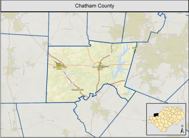
The NCRRP process consists of planning and implementation phases and is managed through North Carolina Emergency Management (NCEM). The counties affected by the storm cover the eastern half of North Carolina and occupy parts of the Piedmont, sandhills and coastal areas of the state.

Data, Assumptions, and Methodologies
County Profile
Demographic Profile
Population
Population Change (2000 to 2010)
Race and Ethnicity
Limited English Proficiency
Poverty
Low and Moderate Income Individuals
Median Household Income
Zero Car Households
Commuting: Travel Time to Work, Means of Transportation
Housing Profile
In Chatham County, 9 percent of housing units are vacant, which is lower than the percentage for North Carolina, 14 percent. Within Chatham County, Moncure has the largest percentage of vacant housing units, 13 percent, while Bennett, Fearrington Village and Gulf have the least: 0 percent. Of the occupied housing units, 77 percent are owner-occupied compared to 65 percent in North Carolina; 23 percent are renter-occupied compared to 35 percent in North Carolina.
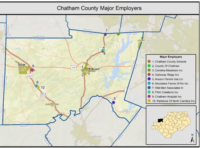
The majority of jobs in Chatham County are in the manufacturing industry, with other jobs coming from retail trade, health care and educational services. According to the US Census Bureau's Longitudinal-Employer Household Dynamics Program, the largest concentrations of jobs within Chatham County are in downtown Pittsboro, downtown Siler City and Ferrington Village.13.
Housing Units By Percentage
Labor Force
Major Employers
Economic Development
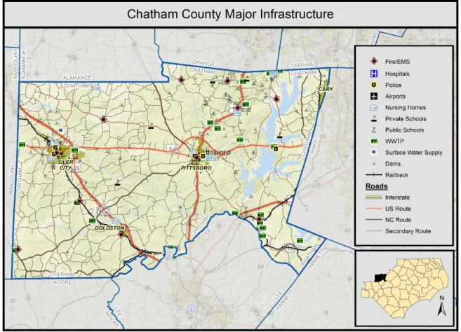
Infrastructure Profile
Transportation
Health
Education
Water
Power
Environmental Profile
Water Resources
Natural and Managed Areas
Biodiversity and Wildlife Habitat
Parks and Recreation
Administrative Profile
Storm Impact
Rainfall Summary
Riverine Flooding Summary
The USGS gauge data generally confirms the limited flooding experienced throughout Chatham County from Hurricane Matthew. In the northeastern part of the county near Chapel Hill, Cedar Lake Road (a private road) was washed out between two dams, stranding or preventing residents from reaching nearby rental homes.
Coastal Flooding Summary
Housing Impacts
Based on meetings with county staff and representatives from several cities in Chatham County, residential impacts from Hurricane Matthew were sporadic and considered minimal. Of the 28 IA claims, only 10 received relief and 8 were located where Cedar Lake Road to the northeast was flooded.
Chatham County - Individual Assistance Flood Damage Claims
About 8 rental units are currently inaccessible in the area, but the units themselves were apparently not damaged. Building footprints were compared to the SFHA to identify areas where flooding could affect populated areas. In general, most of the buildings in the SFHA are located in the most populated areas of Chatham County, including the cities of Siler City, Pittsboro and Moncure.
In the unincorporated areas of the county, most of the buildings in the SFHA are along the Haw River and Haw River tributaries. Based on analysis of claims data, there are approximately two miles of unsurveyed streams in Chatham County that may have experienced flooding but are not designated as SFHA on FEMA FIRM maps. Local officials in the City of Siler requested that the Rocky River Tributary 1 in the 14th Street/15th Street area be studied as well. streets to understand the impacts of flooding in the area.
Economics / Business / Jobs
Infrastructure
Local Siler City officials indicated that the bridge on WWTP Road, which serves as secondary access to the city's wastewater treatment plant, was owned and maintained during Hurricane Matthew. Siler City officials have expressed the need for extensive stormwater improvements to address recurring flooding problems in several locations. Among other potential projects, the city has identified the need to enlarge a culvert at East 5th Street and Camelia Lane and the possibility of daylighting an underground pipe system adjacent to West 2nd Street near North Evergreen Avenue and North Fir Avenue to provide.
Ecosystems / Environment
Strategies for Resilient Redevelopment
Strategies for Resilient Redevelopment
Pillar Action Name Priority Overall Ranking Infrastructure Chatham Infrastructure Action 7: Town of Siler City NCDOT Culvert Upgrade. Infrastructure Chatham Infrastructure Action 5: Jeremiah Drive Roadway Improvement Layer 15 Environment Chatham Environment Action 16: Debris removal from Rock River. Please note that maps are provided for all projects that have a specific location within the country.
Housing Strategies
High Priority Housing Strategies
Senior Center Building Resiliency
Infrastructure Strategies
High Priority Infrastructure Strategies
Backup Power for Chatham County Emergency Shelters
Town of Pittsboro - Critical Facilities Generator Replacement: The generator that serves as backup power for Pittsboro City Hall is unreliable and has failed to operate on several occasions when needed.

Pittsboro Town Hall Backup Power
A comprehensive stormwater management plan is needed to examine existing problems and make recommendations for projects to improve drainage and reduce flooding. The culvert for Loves Creek Tributary 3 at West 5th St is not functioning properly, is too small and will likely need to be replaced. Loves Creek Tributary 2 runs under several parking lots, but the system is too small and causes flooding across the lots.
The culvert to Loves Creek Tributary 1 at North Chatham Av is undersized and will probably need to be replaced. The culverts under West 3rd St and West Raleigh St are likely undersized and contribute to road overtopping and flooding in the area. The rock pipe to Rocky River Tributary 1 at North Av is undersized and contributes to residential structure flooding along 14th St.
Poor drainage on an adjacent property causes flooding in the basement at 223C N Chatham Av four to five times a year.

Siler City Stormwater Improvements
Thompson Street is overflowing with flooding just west of the intersection of Pittsboro Fire Tower Road. When crossing Thompson St, the fire and police department communication tower (critical infrastructure) at the top of Pittsboro Fire Tower Rd is cut off from the west. In addition, traffic volume along Thompson Street is expected to increase dramatically with planned development and construction of a new school.
This project will raise the culvert under Thompson St west of the intersection with Pittsboro Fire Tower Rd.

Pittsboro Stormwater Improvements
Installation of flood meters at 2 locations: Chatham County currently has 1 meter active in the FIMAN system. The installation of additional meters will better prepare the province for flooding and help protect lives by monitoring flood hazards in real time. Two sites have been identified as part of an ongoing mitigation project (Cape Fear River @ Rte 42 and Haw River @ Chicken Bridge Road).
These two locations will monitor the county's two largest sources of flooding upstream and downstream of the county, providing a good understanding of the timing of flooding throughout the county during the event.
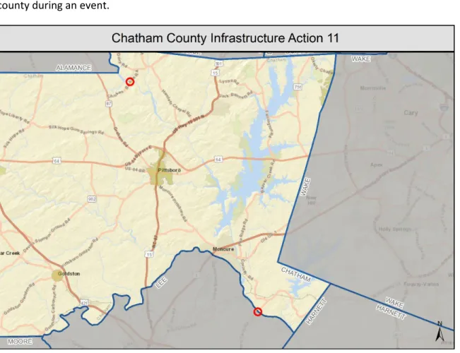
FIMAN Gage Installations
City of Pittsboro - Air Sewer Crossing Improvements: During Hurricane Matthew, the gravity sewer air crossing over Robeson Creek on Sanford Rd was relocated.

Pittsboro Aerial Sewer Crossing Reinforcement
Medium Priority Infrastructure Strategies
Siler City Aerial Sewer Crossing Reinforcement
City of Siler City - NCDOT Culvert Upgrade (2nd Ave): South 2nd Av (NCDOT Road) has crossed Loves Creek several times over the last 15 years.

Siler City Culvert Upgrade
City of Siler City - WWTP Access Bridge Repair: During Hurricane Matthew, the access bridge to the Siler City WWTP over Loves Creek was covered by approximately 2' of water. Although this bridge is no longer the primary access to the treatment plant, it is still used several times a day and provides access to this critical infrastructure.

Siler City WWTP Access Bridge Repair
Siler City – Greenway Trail Repairs: The Greenway Trail in Siler City was originally constructed by NCDOT about a year ago. Ownership and maintenance of the trail was transferred to the town of Siler City.

Siler City Greenway Trail Improvements
City of Pittsboro - Greenway Trail Repairs: The greenway trail in Pittsboro along Robeson Creek downstream of Sanford Rd was washed out during Hurricane Matthew. This project would repair the greenway path using more resilient material (asphalt as opposed to crushed stone).

Pittsboro Greenway Trail Repair
Low Priority Infrastructure Strategies
Jeremiah Drive Roadway Enhancement
Environmental, Ecosystem and Agricultural Strategies Medium Priority Environmental Strategies
Fire Department Equipment Enhancement
Detailed Flood Studies of Unmapped Areas of Future Conditions: There are some areas in the county with identified flooding problems that are not currently mapped by FEMA. Other areas within the county are slated for development with potential flood sources not mapped by FEMA. With the extent of planned development in Chatham County, there is also a desire to consider future conditions in new flood maps.
Unnamed Rocky River Tributary 1 in the area of 14th St, 15th St in Siler.

New Detailed Study of Unmapped Flooding Sources
Low Priority Environmental Strategies
Rocky River Tributary 1 Debris Removal
Summary