TOWN OF TRUCKEE
RECIRCULATED AMENDED
INITIAL STUDY / PROPOSED MITIGATED NEGATIVE DECLARATION
BACKGROUND
Application No.: 2016-00000078/SPA-DP-MUP-TM-CSP
Project Name: Triumph Development Hotel and Residential Project Development Permit and Tentative Map
Project Proponent: Triumph Development
Lead Agency: Town of Truckee Town Council
c/o Truckee Community Development Department 10183 Truckee Airport Road
Truckee, CA 96161 (530) 582-7820
(Documents and other material upon which the decision for the adoption of the Negative Declaration is based may be found at the above location.)
Contact Person: Yumie Dahn, AICP
[email protected] 530-582-2918
Other agencies whose approval may be required (e.g. permits, financing approval, or participation agreement):
Truckee Donner Public Utility District
Regional Water Quality Control Board, Lahontan Region
Department of Transportation, State of California
Department of Fish and Wildlife, State of California
Nevada County Department of Environmental Health
Truckee Fire Protection District
United States Army Corps of Engineers
Truckee Sanitary District
PROJECT DESCRIPTION AND LOCATION
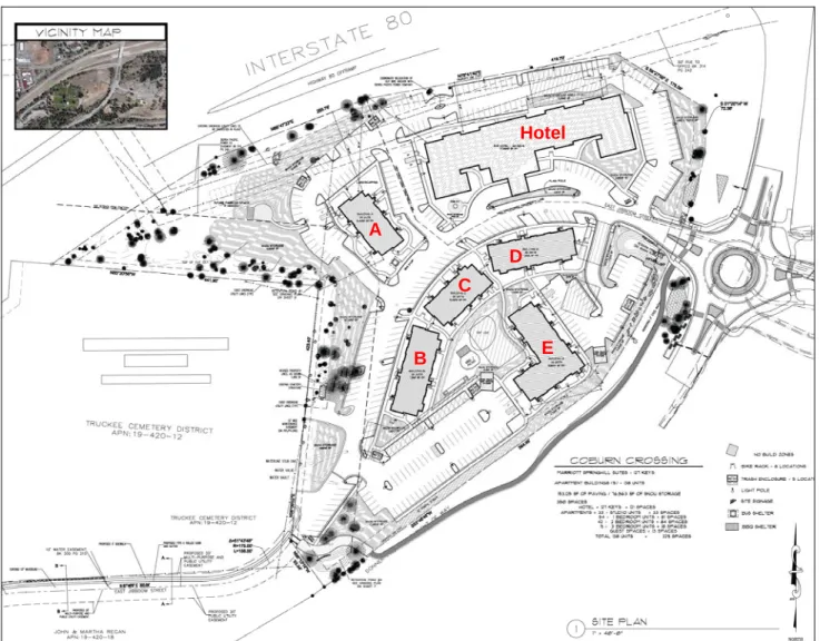
Project Description: Triumph Development is proposing to construct a mixed-use project that includes a 76,435 71, 090 s.f. three-story hotel with 127 114 rooms and five three-story apartment buildings with a total of 138 rental units at 10470 East Jibboom Street. The hotel is proposed to have an exercise room, pool room, small market, prep kitchen with breakfast center, laundry room, business center, break room, meeting room and offices. The apartment buildings are proposed to have a total of 33 studios, 54 one-bedroom units, 42 two-bedroom units, nine three-bedroom units, and common amenities such as barbecue and picnic areas, a bocce ball court, a volleyball court, playground, and rooftop decks. A total of 350 361 parking spaces, including 121 123 hotel parking spaces (four handicap spaces and five ten guest check-in spaces) and 229 238 apartment spaces (eight handicap spaces) are proposed. East Jibboom Street is proposed to be extended through the project site to Donner Pass Road with pedestrian improvements. A Class I trail is also proposed along the southern property line. The parcel is proposed to be subdivided into two parcels – a residential parcel of 7.6 acres and a hotel parcel of 2.8 acres. Overall, the amended project description has reduced the number of hotel rooms from 128 to 114, increased parking from 350 parking spaces to 361 parking spaces. Additionally, Chapter 2, Page 16 of the Downtown Specific Plan, which states, within the Cemetery/267 North site, “Residential units may be located above or adjacent to commercial uses at a density not exceeding four units per acre” is proposed to be amended to ensure consistency with the General Plan 2014-2019 Housing Element, which requires that high-density multi- family residential projects on this site have a minimum density of 16 dwelling units per acre and the Development Code which allows high-density residential in the Downtown Visitor Lodging (DVL) zoning district.
Figure 1 depicts the project location. Figure 2 depicts the proposed site plan, including the hotel and residential components. Figures 3 through 8 include depictions of the proposed hotel and five residential building elevations.
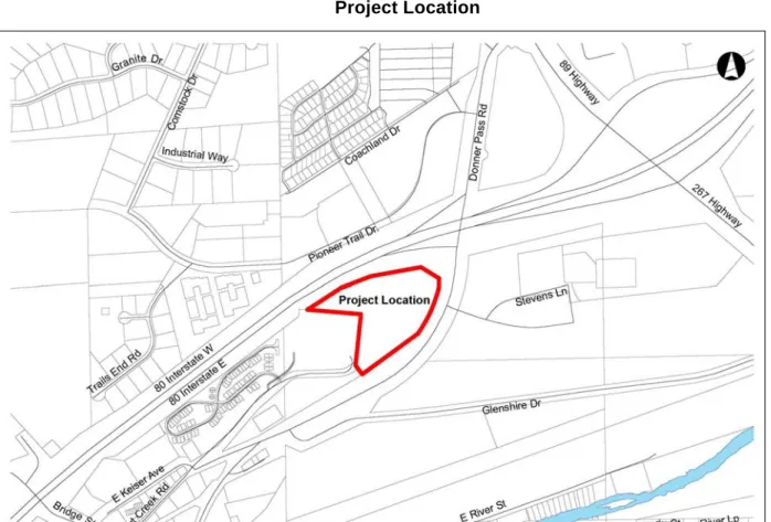
Figure 1 Project Location
Figure 2 Project Site Plan
A
B C
D
E Hotel
Original project with 127-unit hotel
Below is an overview of each of the proposed uses:
Hotel
The new 76,435 71,090 square foot hotel will consist of 127 114 rooms with two stairways and two elevators. The 27,795 26,515 s.f. first floor includes 8,075 8,825 s.f. of common area with lobby and reception, market, breakfast center with prep kitchen, meeting room, exercise room and pool room and 38 32 rooms. The first floor also has luggage storage, restrooms, a laundry room, employee break room, work room, general manager office, sales team office, mechanical rooms, storage rooms, and laundry room. A small coffee shop that would be open to the public is also proposed. The 24,960 22,980 square foot second level has 47 43 rooms, laundry room, and storage rooms. The 23,680 21,650 s.f. third level has 43 39 rooms, laundry, and storage. The rooms have two sizes: 15’8.5”x25’8.5” (404 s.f.) for a one-bed room to 15’8.5”x30’2.75” (475 s.f.) a two-bed room. Each guest room will be equipped with a full bathroom, desk, and sitting area. See Figure 3 for exterior rendering.
The hotel is expected to generate 40-42 employees and will operate seven days a week. Small meeting groups could also be accommodated within the meeting room on the first level.
Amended project with 114-unit hotel
A
B C
D
E Hotel
Hotel Rendering
Residential
Five three-story residential buildings are proposed on the site with a total of 33 studio units, 52 one- bedroom units, 42 two-bedroom units, and nine three-bedroom units. Each unit is proposed to have private open space in a 32 s.f. balcony for the second and third levels or ground level 100 s.f. porches with 12 s.f.
of storage (see Figure 2 for Site Plan):
Building A, located to the west of the hotel, is located separately from the four other residential buildings (See Figure 4 for elevation)
17,030 s.f.
22 storage units on the first level
25 units: seven studio units, 15 one-bedroom units, three two-bedroom units Figure 4
Original Project Design
Amended Project Design
Building A Elevation
Original Project Design
Amended Project Design
Building B (See Figure 5 for elevation)
22,195 s.f.
22 storage units on the first level
25 units: four studio units, six one-bedroom units, 12 two-bedroom units, and three three- bedroom units
Figure 5
Building B Elevation
Original Project Design
Amended Project Design
Building C (See Figure 6 for elevation)
17,030 s.f.
22 storage units on the first level
25 units: seven studio units, 15 one-bedroom units, three two-bedroom units Figure 6
Building C Elevation
Original Project Design
Amended Project Design
Building D (See Figure 7 for elevation)
22,195 s.f.
22 storage units on the first level
25 units: four studio units, six one-bedroom units, 12 two-bedroom units, and three three- bedroom units
Figure 7
Building D Elevation
Original Project Design
Amended Project Design
Building E (See Figure 8 for elevation)
29,030 s.f.
42 storage units (21 on the first level, 10 on the second level, and 10 on the third level)
38 units: 11 studio units, 12 one-bedroom units, 12 two-bedroom units, and three three- bedroom units.
Figure 8
Building E Elevation
The design and layout for Buildings A and C are the same and Building B and D are the same. Building E is unique. Figure 9 shows a rendering of the apartments from the southern corner of the tot lot looking north toward Building C to the west, Building D to the north, and Building E to the east.
Original Project Design
Amended Project Design
Figure 9
Residential Apartments Rendering
Project Location and Environmental Setting: The project area consists of one parcel within the Town of Truckee (10470 East Jibboom Street). The parcel is currently undeveloped, except for a small approximately 165 s.f. cemetery building located along the western property line, however much of the site has been heavily disturbed primarily due to timber harvesting, previous usage as a dump, and site cleanup. The slopes on the site are moderate to flat, ranging from approximately 1% to 5% and sloping downward in a general west to east direction. Elevations range from approximately 5,942 feet near the western corner of the site to approximately 5,930 feet near the eastern property boundary. Ruderal Disturbed/Developed habitat type covers most of the site. It consists of gravel/bare places, dirt and paved roads, and areas that have been heavily disturbed. It is sparsely vegetated with non-native species such as western burnet and bulbous bluegrass intermixed with a few natives such as black foot prairie smoke,
Amended Project Design Original Project Design
wisher-brush, and willowherb. Jeffery pine and lodgepole pine are found along the perimeter of the site with bitterbush, mountain sagebrush, and various common grasses and forbs understory.
Project History: In 2000, the Truckee Town Council approved a Planned Development to set aside an area for a 127-room hotel, construction of two restaurants totaling 10,000 s.f., five retail/commercial buildings totaling 26,200 s.f., two professional office building totaling 16,000 s.f., a maximum of 25 residential units in the second story above the retail or office use, a 625 s.f. visitor information center, and extension of East Jibboom Street through to Donner Pass Road. In 2002, the Truckee Town Council approved a three-story 86,865 s.f.
120-room hotel with 54 studio units, 44 one-bedroom units, and 22 two-bedroom units, 2,500 s.f. of meeting/conference space, support kitchen with 1,000 s.f. exterior second level meeting space, a sport court, pool and spa, and 120 parking spaces. In 2008, the Planning Commission approved a Project Amendment to allow changes to the approved materials for the hotel. In 2007, the applicants applied for grading and building permits for the hotel, two commercial building shells and one commercial/residential mixed use building. The grading and building permits were cancelled by the applicants in 2009 and no improvements were initiated.
Since then, the entitlements and Development Agreement expired in 2011 based on the terms outlined in the Development Agreement. A Mitigated Negative Declaration was approved as part of this original 2000 approval.
Project Baseline: The site is currently undeveloped. However, the majority of the site has been heavily disturbed due to grading related to a previous project that was not developed, timber harvesting, and site cleanup. The northern portion of the project site previously contained a historical debris dump, known as the “Old Truckee Dump” which was used from the 1870s to the 1920s.
The site is proposed to be served by public water and electrical services from Truckee Donner Public Utility District and public sewer by Truckee Sanitary District.
BACKGROUND REPORTS, SUPPORTING DOCUMENTATION AND REFERENCES
The following documents have been used to support the analysis of potential environmental impacts from the proposed project, and are incorporated herein by reference for this Initial Study:
a) Town of Truckee 2025 General Plan (http://www.townoftruckee.com/index.aspx?page=470) b) Town of Truckee Development Code, July 12, 2015
(http://www.townoftruckee.com/index.aspx?page=124) c) Town of Truckee Downtown Specific Plan and EIR
(http://www.townoftruckee.com/departments/redevelopment/truckee-downtown-specific-plan)
EVALUATION OF ENVIRONMENTAL IMPACTS
1. AESTHETICS.
Potentially Significant Impact
Less than Significant with
Mitigation Incorporated
Less than Significant
Impact No Impact
Would the project:
a. Have a substantial adverse effect on a scenic vista?
b. Substantially damage scenic resources, including, but not limited to, trees, rock outcroppings, and historic buildings within a state scenic highway?
c. Substantially degrade the existing visual character or quality of the site and its surroundings?
d. Create a new source of substantial light or glare which would adversely affect day or nighttime views in the area?
Setting
The 10.37-acre property is currently undeveloped but substantially disturbed from the previous use as a Truckee dump and remediation activity since. The slopes on the site are moderate to flat, ranging from approximately 1% to 5% and sloping downward in a general west to east direction. It consists of gravel/bare areas, dirt and paved roads, and areas that have been heavily disturbed. It is sparsely vegetated. The project site is located adjacent to the Truckee Cemetery and Interstate 80 at a gateway to Downtown Truckee.
Impact Discussion
a) While not specifically identified as a scenic vista in the Town of Truckee 2025 General Plan, the property sits adjacent to a prominent Interstate 80 East off ramp at the eastern gateway to Historic Downtown Truckee. Most of the work proposed within the property will occur within previously graded areas and on slopes which are less than 10 percent. Very few trees are proposed to be removed. The project site provides views of the Northstar Mountain Resort. The project would have less-than-significant impacts on a scenic vista.
b) A review of the current Caltrans Map of Designated Scenic Routes indicates that there are no officially designated state scenic highways with the Town of Truckee. Interstate 80 and State Highway 89 (north of Interstate 80) are eligible to become state scenic highways but are not officially designated. The Development Code does designate Interstate 80 as a Scenic Corridor;
however, all development is located outside the corridor boundary. Further, the project area does not have any scenic resources on site. Significant landscaping between Interstate 80 and the project are required and proposed to minimize the visual impact to and from the Interstate. Therefore, the proposed project would have less-than-significant impacts on scenic resources.
c) The immediate visual character of the area surrounding the proposed project area consists of public facilities such as the cemetery, National Forest Office, and the Town of Truckee Corporation Yard. A multi-family residential development is located on the eastern side of the Cemetery with single-family residential and commercial uses in the nearby downtown.
Construction of the proposed hotel and residential uses will be consistent with the use and impact envisioned by the Downtown Specific Plan. The project will be clearly seen by travelers on eastbound and westbound Interstate 80, including those exiting Exit 188A to Truckee, and travelers going south on Donner Pass Road. Visitors to the cemetery would also view the proposed project. The project is required to adhere to a 100-foot cemetery setback where structures are prohibited. At-grade improvements such as parking, driveways, and roads are allowed but must be landscaped to create a visual buffer. The project is required to meet the standards of the Development Code design guidelines and requirements for screening and
from the Railyard and to residents on the opposite side of the valley. Travelers approaching Truckee on State Route 267 from the south would have a view of the residences constructed on this portion. However, dense pine trees along the southern perimeter of the project site and a significant grade difference from Donner Pass Road and the project site are proposed to remain and will provide screening of the residential units.
To ensure the project is adequately screened from public viewsheds and from the cemetery, The Town of Truckee’s Development Code Standards (Development Code Section 18.358.180 – Multi-Family Residential Projects) for this site requires that landscaping be planted at a rate of one for every 20 lineal feet of landscaped area and shrubs shall be planted at a rate of one for every five lineal feet within the Cemetery setback and along the property lines adjacent to Interstate 80. Therefore, the proposed project would have less-than-significant impacts on scenic resources.
d) A lighting plan is proposed as part of the proposed project, including the use of parking light fixtures, sign illumination, and building lighting. The Town of Truckee’s Development Code Standards for exterior lighting require the use of fully-shielded light fixtures which will partially mitigate light and glare impacts associated with the new lighting (Development Code Section 18.30.060 – Exterior Lighting and Night Sky). Additionally the Development Code requires that the total outdoor light output shall not exceed 100,000 lumens per net acre or the lowest level of lumens necessary to meet the lighting requirements of the site. Mitigation Measure 1a requires a photometric study to determine the lowest level of lumens necessary and to prohibit light trespass. A reduction of light fixtures and/or light output is required if the photometric study indicates overlapping of light fields and/or light trespass. Impacts are less-than-significant with mitigation.
Mitigation Measure
1a). Prior to building permit issuance, a photometric study is required for all building, site, and sign lighting for the project. A reduction of light fixtures and/or light output is required if the photometric study indicates overlapping of light fields and/or light trespass.
2. AGRICULTURAL AND FOREST RESOURCES.
Potentially Significant Impact
Less than Significant with
Mitigation Incorporated
Less than Significant
Impact No Impact
In determining whether impacts to agricultural resources are significant environmental effects, lead agencies may refer to the California Agricultural Land Evaluation and Site Assessment Model (1997) prepared by the California Department of Conservation as an optional model to use in assessing impacts on agriculture and farmland. In determining whether impacts to forest resources, including timberland, are significant environmental effects, lead agencies may refer to information compiled by the California Department of Forestry and Fire Protection regarding the state’s inventory of forest land, including the Forest and Range Assessment Project and the Forest Legacy Assessment Project; and forest carbon measurement methodology provided in Forest Protocols adopted by the California Air Resources Board.
Would the project:
a. Convert Prime Farmland, Unique Farmland, or Farmland of Statewide Importance, as shown on the maps prepared pursuant to the Farmland Mapping and Monitoring Program of the California Resources Agency, to non-agricultural use?
b. Conflict with existing zoning for agricultural use, or a Williamson Act contract?
c. Conflict with existing zoning for, or cause rezoning of, forest land (as
defined in Public Resources Code section 12220(g)), timberland (as defined by Public Resources Code section 4526), or timberland zoned Timberland Production (as defined by Government Code section 51104(g))?
d. Result in the loss of forest land or conversion of forest land to non-forest use?
e. Involve other changes in the existing environment which, due to their
location or nature, could result in conversion of Farmland to non- agricultural use or conversion of forest land to non-forest use?
Impact Discussion
a) Eastern Nevada County contains no prime agricultural land based on farmland soil mapping.
Important Farmland Maps prepared pursuant to the Farmland Mapping and Monitoring Program of the California Resources Agency does not include eastern Nevada County and the Truckee area.
For this reason, the project would not result in the conversion of Prime Farmland, Unique Farmland, or Farmland of Statewide Importance to non-agricultural use (California Department of Conservation, 2010). Therefore, there will be no impact.
b) The project is located on commercially designated lands within the Town of Truckee Downtown Specific Plan. The project site consists of multiple properties, none of which are under the provisions of an active Williamson Act Contract. Therefore there is no impact.
c) The project is located on lands zoned for visitor lodging under the Town of Truckee Development Code, which allows hotel uses by-right and allows by-right and incentivizes multi-family residential projects with 11 or more units. There will be no conflict with existing zoning for, or cause rezoning of, forest land, timberland, or timberland zoned Timberland Production. Therefore there is no impact.
d) The site is sparsely populated with trees from the previous use as the Truckee dump and minimal tree removal is proposed to facilitate development of the project. There will be no impact.
e) There will be no changes the existing environment that would result in conversion of farmland to non-agricultural use or conversion of forest land to non-forest use; therefore there is no impact.
Mitigation Measure None required.
References
California Department of Conservation (DOC). 2014. Nevada County Important Farmland Map.
3. AIR QUALITY.
Potentially Significant Impact
Less than Significant with
Mitigation Incorporated
Less than Significant
Impact No Impact
Would the project:
a. Conflict with or obstruct implementation of the Truckee Particulate Matter Air Quality Management Plan or other applicable air quality plan?
b. Violate any air quality standard or contribute substantially to an existing or projected air quality violation?
c. Result in a cumulatively considerable net increase of any criteria pollutant
for which the project region is non-attainment under an applicable federal or state ambient air quality standard (including releasing emissions which exceed quantitative thresholds for ozone precursors)?
d. Expose sensitive receptors to substantial pollutant concentrations?
e. Create objectionable odors affecting a substantial number of people?
Setting
The Town of Truckee is located within the Mountain Counties Air Basin. The Northern Sierra Air Quality Management District (NSAQMD) is the local agency for air quality planning with authority over air pollutant sources within Nevada County, including the Truckee area. Nevada County is currently designated a marginal non--‐attainment area by the State of California for 8 - h o u r ozone (epa.gov).
Reactive organic gases (ROG) are compounds comprising primarily atoms of hydrogen and carbon.
Internal combustion associated with motor vehicle usage is the major source of hydrocarbons. Other sources of ROG include evaporative emissions associated with the use of paints and solvents, the application of asphalt paving, and the use of household consumer products such as aerosols. Adverse effects on human health are not caused directly by ROG, but rather by reactions of ROG to form secondary pollutants such as ozone.
Nitrogen oxides (NOX) serve as integral participants in the process of photochemical smog production.
The two major forms of NOX are nitric oxide (NO) and nitrogen dioxide (NO2). NO is a colorless, odorless gas formed from atmospheric nitrogen and oxygen when combustion takes place under high temperature and/or high pressure. NO2 is a reddish-brown irritating gas formed by the combination of NO and oxygen, a byproduct of fuel combustion. NO2 also contributes to the formation of PM10 (particulates having an aerodynamic diameter of 10 microns—or 0.0004 inch—or less in diameter) and ozone. NOX acts as an acute respiratory irritant and increases susceptibility to respiratory pathogen
Particulate matter consists of solid and liquid particles of dust, soot, aerosols, and other matter, which are small enough to remain suspended in the air for a long period of time. Particulate matter can be divided into several size fractions. Coarse particles (PM10) are between 2.5 and 10 microns in diameter and arise primarily from natural processes, such as wind-blown dust or soil. Fine particles (PM2.5) are less than 2.5 microns in diameter and are produced mostly from combustion or burning activities. Fuel burned in cars and trucks, power plants, factories, fireplaces, and wood stoves produces fine particles. The level of PM2.5 in the air is a public health concern because it can bypass the body’s natural filtration system more easily than larger particles and can lodge deep in the lungs. A portion of the particulate matter in the air is due to natural sources such as wind-blown dust and pollen, which are associated with the aggravation of respiratory conditions. Man-made sources include combustion, automobiles, field burning, factories, and road dust. Primary sources of PM10 emissions are road traffic, construction, open burning,
and wildfires. The amount of particulate matter and PM10 generated is dependent on the soil type and the soil moisture content. Traffic also generates particulate matter emissions through entrainment of dust and dirt particles that settle onto roadways and parking lots.
CalEEMod is a statewide land use emissions computer model accepted by the air districts of California to quantify potential criteria pollutant and greenhouse gas (GHG) emissions associated with both construction and operations from a variety of land use projects. The model quantifies direct emissions from construction and operations (including vehicle and off-road equipment use), as well as indirect emissions, such as GHG emissions from energy use, solid waste disposal, vegetation planting and/or removal, and water use. The mobile source emission factors used in the model (EMFAC2011) includes the Pavley standards and Low Carbon Fuel standards. The model also identifies mitigation measures to reduce criteria pollutant and GHG emissions along with calculating the benefits achieved from measures chosen by the user. The GHG mitigation measures were developed and adopted by the California Air Pollution Control Officers Association (CAPCOA).
For purposes of this assessment, CalEEMod 2013.2.2 was used to quantify emissions and identify mitigation measures to reduce pollutants. The following assumptions were used in the air quality analysis:
3-story, 75,500 square foot hotel;
Hotel parking of 132 spaces;
138 apartment units (includes associated parking).
NSAQMD has developed thresholds of significance to determine air quality impacts and evaluate land use proposals. Thresholds of significance are based on a source’s projected impacts and are a basis from which to apply mitigation measures (NSAQMD 2009). NSAQMD has developed a tiered approach to significance levels: a project with emissions meeting Level A thresholds will require the most basic mitigations; projects with projected emissions in the Level B range will require more extensive mitigations; and those projects which exceed Level C thresholds will require the most extensive mitigations. The NSAQMD-recommended thresholds are identified below:
NSAQMD-RECOMMENDED SIGNIFICANCE THRESHOLDS Significance Level Project-Generated Emissions (lbs/day)
NOX ROG PM10 Level A <24 <24 <79 Level B 25–136 25–136 80–136 Level C >137 >137 >137
Source: NSAQMD 2009
Based on the results of the Air Quality & GHG Assessment using CalEEMod computer model (shown below), the unmitigated projected daily emissions for NOx, ROG, and PM10 are in the Level A and Threshold Ranges:
NOx ROG PM10
Construction 2017 (lbs/day) 53.5 28.4 21.0 Construction 2018 (lbs/day) 46.6 27.3 4.5 Operational – Area (lbs/day) 0.1 6.6 0.1 Operational – Energy (lbs/day) 0.6 0.1 0.1 Operational – Mobile (lbs/day) 30.1 12.3 10.5 Operational – Total (lbs/day) 30.8 19.0 10.7
Impact Discussion
a) By assessing air pollution and emissions associated with this Project and recommending mitigation measures based on Thresholds of Significance established by NSAQMD, the Project complies with both NSAQMD regulations and the Particulate Matter Air Quality Management Plan adopted by the Town of Truckee in July, 1999. As such, the Project does not conflict with or obstruct implementation of any applicable air quality plan and impacts are less-than- significant with implementation of Mitigation Measure 3a.
b) The accepted software program to determine air quality impacts and GHG emissions (CalEEMod, Version 2013.2.2) was used to estimate project emissions for both construction and operational phases associated with this Project. A detailed report of the results is contained in Appendix A.
The Project complies with all local air quality standards and does not contribute to any air quality violations. The proposed building will comply with current California building code regulations (and Title 24 requirements) which will considerably reduce Operational emissions over the long term.
Impacts are therefore less-than-significant.
c) CEQA defines cumulative impacts as two or more individual effects which, when considered together, are considerable or which compound or increase other environmental impacts. The proposed project will not result in a significant increase in particulate matter or other ozone precursors (above the Level A threshold established by NSAQMD). Additionally, Mitigation Measure 3a will ensure than any increase to pollutants related to NOx and ROG are minimal.
Therefore, this impact is considered less-than-significant.
d) Sensitive receptors are people that have an increased sensitivity to air pollution orenvironmental contaminants. Sensitive receptor locations include schools, parks and playgrounds, daycare centers, nursing homes, hospitals, and residential dwelling unit(s). Based on CalEEMod Air Quality Analysis, air pollutants associated with this project are not considered “substantial” or significant under CEQA This impact would be considered less-than-significant.
e) The occurrence and severity of odor impacts depends on numerous factors, including the nature, frequency, and intensity of the source, wind speed and direction, and the sensitivity of the receptors. Land uses commonly considered to be potential sources of odorous emissions include wastewater treatment plants, sanitary landfills, food processing facilities, chemical manufacturing plants, rendering plants, paint/coating operations, and agricultural feedlots and dairies. This project does not propose any uses typical of creating objectionable odors As a result, exposure of sensitive receptors to odorous emissions would be considered less-than-significant.
Mitigation Measures
3a) The project will incorporate the following mitigation measures during the construction phase, as recommended by NSAQMD for emissions within the Level B Threshold range:
Open burning of vegetative material is prohibited. Suitable alternatives are hauling, chipping, mulching, or conversion to biomass fuel
Grid power shall be used (as opposed to diesel generators) for job site power needs where feasible during construction.
Temporary traffic control shall be provided during all phases of construction to improve traffic flow as deemed appropriate by local transportation agencies.
Wood burning appliances shall be prohibited. Each residence shall be equipped with a non-wood burning source of heat
Streets shall be designed to maximize pedestrian access to transit stops.
Prepare a Dust Control Plan in compliance with District / State Rules & Regulations as follows:
Recommended Dust Control Plan Conditions
The applicant shall be responsible for ensuring that all adequate dust control measures are implemented in a timely manner during all phases of project development and construction.
All material excavated, stockpiled, or graded shall be sufficiently watered, treated, or covered to prevent fugitive dust from leaving the property boundaries and causing a public nuisance or a violation of an ambient air standard. Watering should occur at least twice daily, with complete site coverage.
All areas with vehicle traffic shall be watered or have dust palliative applied as necessary for regular stabilization of dust emissions.
All on-site vehicle traffic shall be limited to a speed of 15 mph on unpaved roads.
All land clearing, grading, earth moving, or excavation activities on a project shall be suspended as necessary to prevent excessive windblown dust when winds are expected to exceed 20 mph.
All inactive portions of the development site shall be covered, seeded, or watered until a suitable cover is established. Alternatively, the applicant may apply County approved nontoxic soil stabilizers to all inactive construction areas (previously graded areas which remain inactive for 96 hours) in accordance with the local grading ordinance.
All material transported off-site shall be either sufficiently watered or securely covered to prevent public nuisance, and there must be a minimum of six (6) inches of freeboard in the bed of the transport vehicle.
Paved streets adjacent to the project shall be swept or washed at the end of each day, or more frequently if necessary, to remove excessive or visibly raised accumulations of dirt and/or mud which may have resulted from activities at the project site.
Prior to final occupancy, the applicant shall re-establish ground cover on the site through seeding and watering in accordance with the local grading ordinance.
References
Northern Sierra Air Quality Management District. 2008. Northern Sierra AQMD List of Current Rules, updated April 11, 2008.
Town of Truckee. 1999. Particulate Matter Air Quality Management Plan.
4. BIOLOGICAL RESOURCES.
Potentially Significant Impact
Less than Significant with
Mitigation Incorporated
Less than Significant
Impact No Impact
Would the project:
a. Have a substantial adverse effect, either directly or through habitat modifications, on any species identified as a candidate, sensitive, or special status species in local or regional plans, policies, or regulations, or by the California Department of Fish and Game or U.S. Fish and Wildlife Service?
b. Have a substantial adverse effect on any riparian habitat or other sensitive natural community identified in local or regional plans, policies, or
regulations, or by the California Department of Fish and Game or U.S. Fish and Wildlife Service?
c. Have a substantial adverse effect on federally protected wetlands as defined by Section 404 of the Clean Water Act (including, but not limited to, marsh, vernal pool, coastal, etc.) through direct removal, filling, hydrological interruption, or other means?
d. Interfere substantially with the movement of any native resident or migratory fish or wildlife species or with established native resident or migratory wildlife corridors, or impede the use of native wildlife nursery sites?
e. Conflict with any local policies or ordinances protecting biological resources, such as a tree preservation policy or ordinance?
f. Conflict with the provisions of an adopted Habitat Conservation Plan, Natural Community Conservation Plan, or other approved local, regional, or state habitat conservation plan?
Ecological Setting Project Area Description
The elevation within the project area range from approximately 5,942 feet above mean sea level near the western corner of the site to approximately 5,930 feet above mean sea level near the eastern property boundary. Adjacent land uses include the cemetery and a 2.4-acre multi-family residentially zoned parcel to the west, Interstate 80 to the north and east, and the Tahoe National Forest Truckee office and Town of Truckee Corporation Yard to the south, across the street. The site is located at the edge of the Downtown Study Area. Within the project area, the slopes range from approximately one to five percent, sloping downward in a general west to east direction.
The site was traversed on foot in mid-June 2016 by M. Kelly, PWS, plant ecologist and A. Alterman, wildlife biologist. The purpose of the site visits was to characterize the nature of sensitive habitats in the Study Area and to evaluate the site’s potential to provide habitat for special-status plant and wildlife species. In addition, a preliminary wetland delineation was conducted.
There are delineated wetlands located to the on the eastern boundary of the project, across the street from the Stockrest Springs Road and Donner Pass Road intersection. The Study Area’s hydrologic sources are direct precipitation, typically in the form of snowfall, snowmelt run-off from adjacent areas, rainfall, and shallow ground water near the wetlands. There are no blue line perennial drainages or intermittent/ephemeral drainages. The eastern portion of the property drains toward a Caltrans detention basin at the eastern edge of the property. The primary habitats identified in the June 2016 wetland delineation, prepared by Kelly Biological Consulting, include Ruderal Disturbed. Jeffery Pine Woodland is found along the southern and northern perimeter of the site. The major tree species include Jeffrey pine (Pinus jeffreyi) and lodgepole pine (Pinus contorta). The understory is made up of bitterbrush (Purshia tridentata) and mountain sagebrush (Artemisia tridentata ssp. vaseyana) and various common grasses and forbs. Wet Meadow (wetland) habitat type can be found in a very small area near the Caltrans detention basin which is adjacent to the northeastern part of the site. The dominants in area are Baltic
rush (Juncus balticus ssp. ater), various grasses such as bog bluegrass (Poa palustris), and forbs including marsh gnaphalium (Gnaphalium palustre) and baby blue eyes (Nemophila pedunculata). There are also several small willows (Salix lemmonii). The upper edges transition into adjacent upland habitats.
The twenty-six special status plant species that have been recorded within the vicinity or have geographic ranges that overlap with the Study Area are listed in Table 1 (CNDDB 2016). No special status species have been observed within the Study Area. Due the heavily disturbed condition of the site, none of these species have a high potential (or even moderate potential) to occur in the Study Area. Two species have a low-moderate potential, Plumas ivesia (Ivesia sericoleuca), which occurs about one half mile to the east and Santa Lucia dwarf rush (Juncus luciensis). Neither were observed during the survey. There are no sensitive plant communities in the Study Area.
Resident and migratory wildlife species may utilize the habitats found in the Study Area for foraging, breeding, and shelter. Evidence of species typical of the Truckee area, such as Douglas squirrel (Tamiasciurus douglasi), black-tailed jackrabbit (Lepus californicus), and yellow-pine chipmunk (Neotamias amoenus) was noted. In addition, Mountain Chickadee (Poecile gambeli), American Robin (Turdus migratorius), Western Scrub-Jay (Aphelocoma californica), Steller’s jay (Cyanocitta stelleri), House Finch (Carpodacus mexicanus), Lesser Goldfinch (Carduelis psaltria), and Western Wood-Pewee (Contopus sordidulus) were observed. A summary of avian taxa noted in or adjacent to the Study Area during the site visit can be found in the Appendix.
Twenty-six special status wildlife species have been recorded within the vicinity or have geographic ranges that overlap with the Study Area (CNDDB 2016). None of the 26 species have a moderate or high potential occur in the Study Area. All are either not present or have a low potential.
There are two small areas that exhibit wetland indicators and potentially fall within the Corps and the RWQCB jurisdiction in accordance the CWA and Porter Cologne. They are on the northeast of the property, extending off the site (near the off-site Caltrans stormwater detention basin) (Figure 2). One is 166 square foot (0.004 acres); the other is 3,068 square foot (0.07 acres). Both are dominated by wetland vegetation such as marsh gnaphalium (Gnaphalium palustre) (FACW) and baby blue eyes (Nemophila pedunculata) (FAC). Also present are Baltic rush (Juncus balticus ssp. ater) (FACW) and bog bluegrass (Poa palustris) (FAC) and other wetland species. The larger one has denser vegetation. They also exhibited wetland hydrologic indicators and wetland soil. There were algal mats in the small one. These areas appear to drain north/east to the Caltrans stormwater basin, which in turn discharges to the east into a culvert under Donner Pass Road. On the east side of the road, water flows out of the culvert into a small stormwater basin, which then discharges to the east into a sinusoidal intermittent drainage, then filters into the soil. It does not appear to connect to any surface water drainages that eventually lead to the Truckee River. It is possible that the Corps would consider it an isolated wetland that is not jurisdictional. It should be noted that only the Corps can make that jurisdictional determination. Therefore they should be consulted, before it is filled or altered. Regardless of the Corps’ determination, the area would typically be considered a Waters of the State by the RWQCB. To fill it would require their approval.
Regulatory Setting
The following discussion identifies federal and State environmental regulations that serve to protect sensitive biological resources relevant to the proposed project and CEQA review process.
Special-Status Species
Special-status plants and animals are species that are legally protected under the State and Federal Endangered Species Acts, and other regulations, and species that are considered rare by the scientific community. They are defined as:
Plants and animals that are listed or proposed for listing as Threatened or Endangered under the California Endangered Species Act (Fish and Game Code 1995 §2050 et seq., 14 CCR §670.1 et
seq.) and/or the Federal Endangered Species Act (50 CFR 17.12 for plants, 50 CFR 17.11 for animals; and various notices in the Federal Register for proposed species).
Plants and animals that are Candidates for possible future listing as Threatened or Endangered under the Federal Endangered Species Act (50 CFR 17.12 for plants, 59 FR 58982 November 15, 1994 for animals).
Plants and animals that are considered Federal Species of Concern (formerly C2 candidate species).
Plants and animals that meet the definition of rare or endangered under CEQA (14 CCR §15380), which includes species not found on State or Federal Endangered Species lists.
Animals that are designated as "Species of Special Concern" by CDFW (1999).
Animal species that are "fully protected" in California (Fish and Game Code, §3511, §4700,
§5050 and §5515).
Special-status plant species also include species on CNPS Inventory List 1A (presumed extinct in California), List 1B (plants rare, threatened, or endangered in California and elsewhere), or List 2 (plants rare, threatened, or endangered in California, but more common elsewhere). These species fall within state regulatory authority under the provisions of the California Environmental Quality Act (CEQA) Guidelines. CNPS Inventory List 3 (plants about which more information is needed, a review list) and List 4 (plants of limited distribution, a watch list) are considered to be of lower sensitivity, and generally do not fall under specific state or federal regulatory authority. Specific mitigation considerations are generally required for species with federal or state protection or that are in List 1 and 2 categories.
Sensitive plant communities include habitats that fulfill special functions or have special values. Natural communities considered sensitive are those identified in local or regional plans, policies, regulations, or by the California Department of Fish and Wildlife (CDFW). CDFW ranks sensitive communities as
‘threatened’ or ‘very threatened’ and keeps records of their occurrences in its Natural Diversity Database.
Also, CNDDB vegetation alliances are ranked 1 through 5. Alliances ranked globally (G) or statewide (S) as 1 through 3 are considered sensitive (Sawyer, et.al. 2009). Impacts to sensitive natural communities identified in local or regional plans, policies, regulations, or by CDFW or U.S. Fish and Wildlife Service (USFW) must be considered and evaluated under CEQA.
Sensitive habitats may include areas that fulfill special functions or have special values, such as wetlands, streams, and riparian habitat. These habitats may be regulated under federal regulations (i.e. the Clean Water Act), state regulations (such as the Porter-Cologne Act, California Department of Fish and Wildlife’s Streambed Alteration Program), and local ordinances or policies.
Wetlands and Waters of the U.S.
The U.S. Army Corps of Engineers (Corps) regulates “Waters of the United States” pursuant to Section 404 of the Clean Water Act (CWA). “Waters of the US” are defined broadly as waters potentially used in commerce, including interstate waters and wetlands, all other waters (intrastate waterbodies, including wetlands), and their tributaries (33 CFR 328.3). Potential wetland areas are determined by the three criteria stated in the Corps of Engineers Wetlands Delineation Manual (“Manual”) (1987) and the Western Mountains, Valleys, and Coast Regional Supplement (“Supplement”) (2010). Those criteria are hydrophytic vegetation, hydric soils, and wetland hydrology. Areas that are inundated for sufficient duration and depth to exclude growth of upland and hydrophytic vegetation are subject to Section 404 of the CWA jurisdiction as “other waters” and are often characterized by an ordinary high water line. “Other waters” generally include lakes, rivers, streams, and their tributaries. The placement of fill material into Waters of the US (including wetlands) generally requires authorization from the Corps under Section 404.
Waters of the State
Waters of the State are regulated by the Regional Water Quality Control Board (RWQCB) pursuant to the State Water Quality Certification Program, which regulates discharges of fill and dredged material under
Section 401 of the CWA and the Porter-Cologne Water Quality Control Act. “Waters of the State” are defined by the Porter-Cologne Act as “any surface water or groundwater, including saline waters, within the boundaries of the state”. RWQCB protects all waters in its regulatory scope, but has special responsibility for wetlands, riparian areas, and headwaters. These waterbodies have high resource value, are vulnerable to filling, and are not systematically protected by other programs. RWQCB jurisdiction includes wetlands and waters that may not be regulated by the Corps pursuant to Section 404.
Projects that require a Corps permit, or fall under other federal jurisdiction, and have the potential to impact Waters of the State, are required to comply with the terms of the Water Quality Certification determination. If a proposed project does not require a federal permit, but does involve dredge or fill activities that may result in a discharge to Waters of the State, the RWQCB has the option to regulate the dredge and fill activities under its state authority in the form of Waste Discharge Requirements.
Migratory Bird Treaty Act
This treaty with Canada, Mexico and Japan makes it unlawful at any time, by any means or in any manner, to pursue, hunt, take, capture, or kill migratory birds. The law applies to the removal of nests (such as swallow nests on bridges) occupied by migratory birds during the breeding season. California Fish and Game Code (Sec 3500) also prohibits the destruction of any nest, egg, or nestling.
Town of Truckee Development Code
Development Code Section 18.30.050.F.3 requires Minor Use Permit approval for any disturbance within 300 feet of a wetland. Development Code Section 18.30.050.B.3 also requires that runoff into wetland areas shall not be increased above or decreased below pre-project levels and that runoff into wetland areas shall be treated prior to release into the wetland. The purpose of these requirements is to ensure that there will be no indirect impact to wetlands due to project proximity or operations. Because the delineated wetlands are located adjacent to parking areas where snow removal equipment and other activity may accidentally encroach into existing wetlands, the proposed project may have potential impacts to wetlands if not mitigated.
Impact Discussion
a) The proposed improvements are largely located in areas that have been disturbed. Due to the amount of disturbance that has already occurred on the site, it is unlikely that the project area provides suitable habitat for wildlife. The exception to this could be the existing Jeffrey pine tree stands on the north, west, and south perimeter of the property. However, most of the Jeffrey Pine trees are located outside the property boundaries and only one 42” pine, one 32” pine, one 8”
pine, one 16” pine, and one 12” pine are proposed to be removed as a result of construction which could impact the migratory birds or raptors. It should be noted that, of the 26 special status wildlife species that have been recorded within the vicinity or have geographic ranges that overlap with the Study Area, none have a moderate or high potential to occur in the Study area. All are either not present or have a low potential. Additionally, the proposed landscape plans anticipate addition of 91 native evergreen trees (Lodgepole pine and Jeffrey Pine), 57 canopy trees (Mountain Ash), 140 native tree groves (Quaking Aspen and Western Birch), 16 deciduous native trees (Mountain Maple), and 107 small-scale accent trees (Amur Maple, Crabapple, and Lilac) which could create potential new habitat to accommodate the lost habitat. Mitigation Measure 4a will reduce potential impacts to less-than-significant.
b) No riparian habitats or other sensitive natural community identified in local or regional plans, policies or regulations, or by the California Department of Fish and Game or U.S. Fish and Wildlife Services exist within the project site. Therefore, there will be no impact.
c) Mitigation Measure 4b requires installation of both temporary construction fencing, and permanent fencing or equivalent permanent barrier between all parking areas and adjacent
Prior to issuance of any grading, demolition, or building permits, the applicant shall provide a wetland fencing plan consistent with Mitigation Measures 4b through 4e to the Community Development Director for review and approval. The Director shall verify that the intent of this mitigation—to protect the wetlands from accidental disturbance—is met. Implementation of this mitigation measure will ensure that all wetlands are permanently protected from accidental disturbance such as but not limited to disturbance snow removal equipment, walking paths, etc.
Mitigation Measure 4d requires that the applicant address Development Code Section 18.30.050.B.3 as part of the required drainage report. The Town Engineer shall verify compliance with this mitigation prior to grading, demolition, or building permit issuance. Section 18.30.050.B.3 requires that wetlands be protected from stormwater runoff such that runoff does not adversely affect the health, function and values of the wetland.
Mitigation Measure 4e requires the placement of informational signs stating “Protected Wetland Area, Do Not Disturb” every fifty feet along the permanent wetland barrier. These signs shall be maintained by the property owner in perpetuity. This mitigation further protects wetlands from human disturbance.
Implementation of Mitigation Measures 4b through 4e will reduce potential impacts to less- than-significant.
d) The proposed improvements are largely located in areas that have been disturbed. Due to the amount of disturbance that has already occurred on the site, it is unlikely that the project area provides suitable habitat for wildlife. The exception to this could be the existing Jeffrey pine tree stands on the north, west, and south perimeter of the property. However, most of the Jeffrey Pine trees are located outside the property boundaries and only one 42” pine, on 32” pine, one 8” pine, one 16” pine, and one 12” pine are proposed to be removed as a result of construction which could impact the migratory birds or raptors. It should be noted that, of the 26 special status wildlife species that have been recorded within the vicinity or have geographic ranges that overlap with the Study Area, none have a moderate or high potential to occur in the Study area. All are either not present or have a low potential. Additionally, the proposed landscape plans anticipate addition of 91 native evergreen trees (Lodgepole pine and Jeffrey Pine), 57 canopy trees (Mountain Ash), 140 native tree groves (Quaking Aspen and Western Birch), 16 deciduous native trees (Mountain Maple), and 107 small-scale accent trees (Amur Maple, Crabapple, and Lilac) which could create potential new habitat to accommodate the lost habitat. Mitigation Measure 4a will reduce potential impacts to less-than-significant.
e) The Town of Truckee recognizes the importance of trees and regulates the removal of trees through Development Code Section 18.30.155. While tree removal is not specifically prohibited within the Development Code, requirements are in place to ensure that trees designated for preservation in the site plans are able to survive following construction. In particular, the Code requires a tree removal permit be obtained for tree removals and that the applicant prepare a tree protection and tree preservation plan with the permit submittal. Most of the Jeffrey Pine trees are located outside the property boundaries and only one 42” pine, one 32” pine, one 8” pine, one 16”
pine, and one 12” pine are proposed to be removed as a result of construction. A tree preservation and protection plan is required as part of the project approval. The tree protection plan is required to be in compliance with the Town of Truckee Development Code Section 18.30.155. Mitigation Measure 4f will reduce potential impacts to less-than-significant.
f) Currently there are no known adopted habitat conservation plans that would result in conflicts with the project. The project site is located adjacent to Interstate 80 which limits its habitat value, and restricts wildlife movement. No impact would occur.
Mitigation Measures
4a) Pre-construction surveys for tree-nesting raptors and migratory songbirds shall be conducted within 15 days prior to any construction that will occur between March 15 and August 31 of any given year. If ground-disturbing activities are delayed or suspended for more than 30 days after the pre-construction survey, the site shall be resurveyed. Preconstruction surveys shall be conducted by a qualified biologist. All suitable nesting habitat for tree nesting raptors and migratory songbirds shall be surveyed within 250 feet of the proposed project impact area. Should active nests be identified by these surveys, the nest sites shall be protected from all construction activities within 250 feet of the nest site until the young have fledged. Should construction activities cause the nesting migratory bird to vocalize, make defensive flights at intruders, get up from a brooding position, or fly off the nest, then increase the exclusionary buffer such that activities are far enough from the nest to stop this agitated behavior by the raptor or songbird. The exclusionary buffer should remain in place until the chicks have fledged or as otherwise determined by a qualified biologist. Construction activities that must occur within 250 feet of an active nest shall not take place without prior consultation with California Department of Fish and Wildlife.
4b) Temporary construction fencing and permanent fencing or equivalent permanent barrier is required to be installed between all parking area and adjacent wetlands, such as placing orange exclusion fencing, staked fiber rolls, and keyed-in silt fencing. Prior to issuance of any grading, demolition, or building permits, the applicant shall provide a wetland fencing plan to the Community Development Director for review and approval. The Director shall verify that the intent of this mitigation—to protect the wetlands from accidental disturbance—is met. The following performance measures are required to be included in the wetland fencing plan:
All fencing or barriers shall be installed outside the limits of the delineated wetlands.
All fencing material shall be a split board or rail fence not exceeding three boards or three rails high. Fencing materials shall be constructed with earth-toned materials.
4c) Prior to improvement plans, the applicant shall identify the wetland areas in the grading and drainage plan for the project. Impacts to the potential wetland areas should be avoided if possible.
Prior to approval of Improvement Plans, a preliminary delineation of Waters of the United States should be submitted to the Corps for verification. If avoidance is not feasible, then impacts should be minimized. The wetland area may be included in a retention area designed as part of the grading and drainage for the project. If the Corps determines that the wetlands are not in their jurisdiction, then no further actions by the Corps are required. If the Corps determines the areas are within their jurisdiction, then Corps authorization should be obtained before construction near the wetlands.
If the Corps does not take jurisdiction over the wetlands, these areas would still be considered Waters of the State. If avoidance is not feasible, then impacts should be minimized and a permit obtained from the RWQCB in accordance with Porter Cologne Act. As part of either the federal or state permit process, compensatory mitigation typically involves one or more of the following, wetland enhancement, restoration, creation, or preservation. The mitigation goal should be to implement it within the same regional watershed. If that is not feasible, in a nearby watershed or fee-based mitigation may be considered. Work should comply with all agency permit requirements.
4d) The applicant shall address Development Code Section 18.30.050.B.3 which requires that no net increase in wetland runoff/runoff as part of the required drainage report. The Town Engineer shall
4e) Informational signs shall be installed every fifty feet along the permanent wetland barrier. These signs shall be maintained by the property owner in perpetuity. This mitigation further protects wetlands from human disturbance stating “Protected Wetland Area, Do Not Disturb.”
4f) The applicant shall address Development Code Section 18.30.155, Tree Preservation which includes fencing at the dripline of all trees, no grade cuts or fill within six feet of the trunk of a tree to be retained or within the dripline, paving within the dripline shall be stringently minimized with no paving within six feet of the trunk.
References
Kelly Biological Consulting. 2016. Biological Constraints Analysis, Coburn Crossing.
5. CULTURAL RESOURCES.
Potentially Significant Impact
Less than Significant with
Mitigation Incorporated
Less than Significant
Impact No Impact
Would the project:
a. Cause a substantial adverse change in the significance of a historic resource as defined in Section 15064.5 of the CEQA Guidelines?
b. Cause a substantial adverse change in the significance of an archaeological
resource pursuant to Section 15064.5 of the CEQA Guidelines?
c. Directly or indirectly destroy a unique paleontological resource or site or
unique geologic feature?
d. Disturb any human remains, including those interred outside of formal
cemeteries?
Background Setting
(Summarized from Lindström et al, 2010)
The earliest human occupation of northeastern California and northwestern Nevada is generally agreed to have occurred approximately 12,500 years before present (BP). Climate data indicate that most of the upper elevations in the northern Sierra were covered in glacial ice until sometime after 14,000 years ago.
In the Tahoe Basin, alpine vegetation was gone by 10,000 BP, perhaps giving way to an environment more hospitable to humans.
The Town of Truckee lies within the ethnographic territory of the Washoe Tribe of Nevada and California.
In the 1850s, when non-natives began moving into their territory, the Washoe homeland surrounded Lake Tahoe and the Sierra Nevada, south from Honey Lake, through Antelope Valley and the West Fork of the Walker River; and east from the western slopes to the top of the Pine Nut Mountains in the Great Basin.
The traditional life way was based on seasonally harvested resources—fish, animals, and plants—from catchments tethered to areas associated with specific lineages. Social networks extended visiting rights and resource procurement well beyond these borders, but neighbors generally respected familial use- rights to specific areas and associated resources, and observed protocols for gaining access to hunt or collect resources outside their domains.
After initial and sporadic resistance to Euro-Americans appropriating camping and resource areas by
“gradual encroachment” during the 1860s-1870s, Washoe leaders are said to have advised a strategy of accommodation and negotiation. They distanced themselves from the Pyramid Lake Paiute War of 1860, for instance, and sought assistance from federal agents for protection of their fisheries, pine nut groves,
and other resources. The Washoe tribe achieved federal recognition in 1936 after establishing a government and constitution under authority of the Indian Reorganization Act of 1934.
Several themes dominate historic-period events within the project area, including mining and ice production, which are both directly relevant to significant archaeological remains located within the project corridor. In their quest for gold in 1849, many Gold Rush immigrants passed through the Truckee Basin, as they followed the Truckee Route of the Emigrant Trail, and crossed the Sierra in the vicinity of Donner Pass. The discovery of silver in Nevada in 1859 prompted a reverse migration, with many east-bound miners heading back through the Truckee Basin from the gold fields of the Mother Lode to the mines of the Comstock.
By the mid-1880s, the Truckee River and its tributaries had become a focus for the Sierra Nevada ice industry. Attracted by the steady flows of Martis Creek and its close proximity to the railroad and the existing infrastructure in place at Martis Creek Station, the Truckee Ice Company set up operations at the mouth of the creek in 1884. The company was acquired by Union Ice Company by 1891, and operations closed in 1898. In 1886, a second ice company, the Tahoe Ice Company, commenced simultaneous operations a short distance upstream. Like the Truckee Ice Company, in 1915 they sold out at the turn of the twentieth century to a large competitor, the National Ice Company. Operations closed a few years later due to river pollutants and competition with manufactured ice companies.
One historic site, one historic isolate, and two prehistoric sties have been documented within the project area:
1) Isolate P -29-1129: As noted in the discussion above re. NCIC Report No. 3413, in 1985 Alfred Farber identified scattered, light density historic trash at two locations within the present project area, recording these features as Isolate Feature P-29-1129. Given the extent and degree of disturbance, coupled with mixing of artifacts dating to substantially different time periods and representing different activities, the Isolate was recommended not significant per any of the evaluative criteria in CEQA. A variety of activities were undertaken within or near the Isolate subsequent to its 1985 recording, essentially destroying what little integrity characterized this historic trash scatter.
2) Historic Site CA-NEV-532-H: This is an extensive area of trash apparently utilized for approximately 50 years (beginning around 1880 and extending to circa. 1930), situated on a flat between Interstate 80 and the bluff above and overlooking the Truckee River. Although most of the site was identified as lying east of Highway 89 (SR 267, Donner Pass Road), a small portion, extensively impacted and substantially "looted", was observed to the west of Highway 267 within the present project area's southeast comer. Original recording of the site occurred in 1972 by the US Forest Service in conjunction with the Hopkins Land Exchange Project. At that time and as part of Forest Service consultation requirements, the site record was submitted to the California State Historic Preservation Office (SHPO) for concurrence with Forest Service recommendations that portions of the site located easterly of realigned Highway 89 retained sufficient integrity to contribute to National Register eligibility and significance per CEQA. SHPO concurred, and in 1981 this site was listed with a 2S1 NRHP status (determined eligible for separate listing by the Keeper of the National Register). This status remained in effect through 2000.
The site was revisited in 1986 by Caltrans' archaeologist Henry Bass, who prepared a new site record in which he describes the site as extensively impacted by a variety of historic through contemporary activities, including (1) construction and/or realignment of adjacent highways and Interstate 80, (2) construction of a helicopter landing pad, (3) past logging, (4) extensive