That the Regional Planning Committee receive the report dated 15 February 2019, entitled "Manager's report" for information. Minutes of the Regular Meeting of the MVRD Regional Planning Committee held on Friday, 8 March 2019 Page 7 of 8 6.
Article from The New York Times dated January 24, 2019
Article from The Globe and Mail dated January 26, 2019
Article from The Globe and Mail dated January 26, 2019
BUSINESS ARISING FROM DELEGATIONS No items presented
RESOLUTION TO CLOSE MEETING No items presented
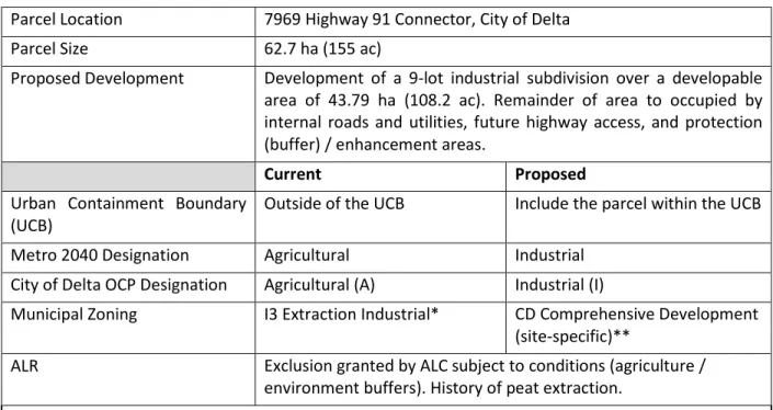
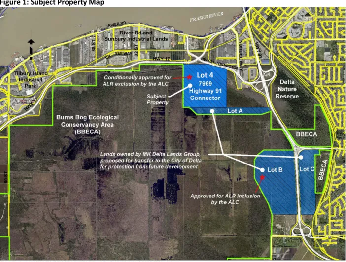
Subject: Metro 2040 Land Use Direction Amendment Request from the City of Delta – MK Delta Lands. Metro 2040 Land Use Direction Amendment Request from the City Impact – MK Delta Lands Regional Planning Committee Regular Meeting Date: 5 April 2019 Page 4 of 9.
CREATE A COMPACT URBAN AREA
The proposed Metro 2040 amendment also creates the need for a revised regional context statement of the City of Delta so that the mapping in the City's OKP, the RCS and Metro 2040 will be consistent. Metro 2040 Land Use Directive Amendment Request from the City Impact – MK Delta Lands Regional Planning Committee Regular Meeting Date: 5 April 2019 Page 5 of 9.
SUPPORT A SUSTAINABLE ECONOMY Strategy 2.2: Protect the supply of Industrial land
PROTECT THE ENVIRONMENT AND RESPOND TO CLIMATE CHANGE IMPACTS Strategy 3.1: Protect Conservation and Recreation lands
Metro Vancouver staff recommends that additional information be sought from the City of Delta regarding potential impacts and planned mitigation efforts for the addition of fill. Staff also recommends that the City of Delta consult with the Burns Bog Science Advisory Committee regarding these potential impacts.
SUPPORT SUSTAINABLE TRANSPORTATION CHOICES
Metro 2040 Land Use Designation Change Request from the City of Delta - Regular Meeting of the MK Delta Lands Regional Planning Commission Date: April 5, 2019 Page 6 of 9. That the MVRD Board deny the proposed change for the MK Delta Lands and notify the City of Delta of the decision.
Urban Containment Boundary and General Urban Areas
Industrial and Mixed Employment Areas
Local Centres, Hospitals and Post-Secondary Institutions
Promote land development patterns that support a diverse regional economy and employment close to where people live
This privately owned land is currently located outside the Burns Bog Ecological Conservation Area. A covenant will be registered on the property in question which will require implementation and monitoring of the proposed mitigation measures. A fence will be placed at the top of the slope to prevent public access to the buffer areas and the adjacent Burns Bog.
A regional TOAH fund is a financing tool that supports regional policy goals on integrating transit and affordable rental housing
A regional TOAH fund is a financing instrument that supports regional policy objectives related to the integration of transit and affordable rental housing.
Given high land costs, land acquisition would likely be a limited component of a regional TOAH fund in Metro Vancouver
The non-profit housing sector would likely benefit from a regional TOAH fund
Transit-Oriented Affordable Housing Study Phase 2 – Key Findings Regional Planning Committee Regular Meeting Date: April 5, 2019 Page 3 of 9. Transit-Oriented Affordable Housing Study Phase 2 – Key Findings Regional Planning Committee Regular Meeting Date: April 5, 2019 Page 4 of 9. Partnerships, Simple Governance Structure , professional fund management and adaptable scope are best practices for a regional TOAH fund.
Partnerships, simple governance structure, professional fund management, and adaptable scope are best practices for a regional TOAH fund
A regional champion(s) is required to take the next step
Use lands under public or non-profit ownership strategically for transit-oriented affordable rental housing
Transit Oriented Affordable Housing Study Phase 2 – Key Findings Regional Planning Committee Regular Meeting Date: April 5, 2019 Page 5 of 9. Continue to use increases in allowable density for market housing to achieve supply of new housing for affordable rent.
Continue to use increases in the allowable density for market housing to achieve new affordable rental housing supply
Use housing agreements to ensure long term affordability of rental housing units
Residential rental tenure zoning can be applied for rental preservation and, in specific situations, protect the opportunity for new affordable rental housing supply
Transit Oriented Affordable Housing Study Phase 2 – Key Findings Regional Planning Committee Regular Meeting Date: April 5, 2019 Page 6 of 9.
Weigh ownership and location options of privately developed affordable rental housing units
New advances in land use, affordable rental housing, and transit planning are required
Transit-Oriented Affordable Housing Study Phase 2 – Key Findings Regular Meeting of the Regional Planning Committee Date: April 5, 2019 Page 7 of 9. A regional TOAH fund shows promise as a financial instrument that could incrementally improve the delivery of affordable rental housing in transit. oriented locations. Transit-Oriented Affordable Housing Study Phase 2 – Key Findings Regional Planning Commission Regular Meeting Date: April 5, 2019 Page 9 of 9.
A regional TOAH fund is a financing tool that supports regional policy goals on integrating transit and affordable rental housing
Given the high cost of land, land acquisition would likely be a limited component of the TOAH Regional Fund in Metro Vancouver. The TOAH Fund could help open up opportunities for the non-profit housing sector in the region by serving as an additional source of rapid response and low-cost financing. Metro Vancouver could continue to convene necessary parties to explore opportunities for the TOAH Fund and help identify potential interested champions.
Acquire lands strategically when planning for transit and / or redevelopment along the Frequent Transit Network
Use publicly owned or nonprofit lands strategically for transit-oriented affordable rental housing. Creative approaches are possible (and necessary) to make better use of existing lands that are controlled by public or non-profit entities, especially along the Frequent Transit Network. One potential synergy is to provide qualified nonprofit housing developers with the right of first refusal to develop these surplus public lands.
Continue to use increases in the allowable density for market housing to achieve new affordable rental housing supply
On private (ie, previously undeveloped or vacant) lots, parcels with uses of currently low economic value, or parcels transitioning from institutional to residential, the application of zoning for residential rental rights will remove strata development pressures and can increase sustainability for market/affordable rental housing projects. If the current use on a privately owned parcel has an economic value that is greater than a new market or a new affordable housing project, then the underlying parcel may simply become a holding property, which is no longer available for redevelopment in the short term. In general, unless accompanied by increased market housing density, current rental zoning authority is unlikely to facilitate the creation of new affordable rental housing supply.
New advances in land use, affordable rental housing, and transit planning are required
Subject: Land value capture and opportunities for regional transport and transit-oriented low-cost rental housing. Land value capture and opportunities for regional transport and transit-oriented low-cost rental housing Regional planning committee regular meeting date: 5 April 2019 Page 2 of 5. Land value capture and opportunities for regional transport and transit-oriented low-cost rental housing Regional planning committee Regular meeting date: 5 April 2019 Page 3 of 5.
DRAFT
Regional Long-Range Growth and Transportation Scenarios
SUMMARY REPORT
APRIL 2019 ATTACHMENT 2
Executive Summary
What Sort of Future Are We Planning For?
25 external forces considered
What is Scenario Planning?
Scenario planning in Metro Vancouver
Current economic, growth and development trends continue. Automation-induced job losses and emigration result in a regional economy in decline. Barriers to global trade encourage a more self-sufficient regional economy. Automation is driving a new economic boom, led by new creative and knowledge sectors.
The Four Scenarios
Climate Change
More extreme rainfall events, especially in the wettest parts of the year, increase the risk of localized flooding in streets, businesses and homes. An increased number and duration of summer fires will affect air quality in the region, affect community health and may reduce the desire to walk and cycle. Of the climate change impacts expected in this region, flooding will have the greatest potential to affect land use and transportation systems.
Understanding the Scenarios
Four Possible Futures Compared--2050 Scenarios
Indicator Today SCENARIO A SCENARIO B SCENARIO C SCENARIO D
In the region by 2050, automation is common in repetitive, labor-intensive jobs such as farming, primary manufacturing, and in many retail and service industries. Improved productivity from automation and continued growth in consumer demand overseas is leading to increased global trade through the Metro Vancouver Gateway. Overall, the region continues to focus growth in urban centers and corridors, in line with current regional and local plans.
Current economic, growth and development trends continue
People choose or are forced to seek housing outside the region and commute longer distances. The region remains an attractive place to live, but the cost of living and housing remain high, especially in urban centers. Population continues to grow in flood-prone areas increasing vulnerability during flooding from rivers and due to sea level rise.
Automation-driven job losses and outmigration result in a regional economy in decline
There is less travel throughout the region, but some individuals have to travel much more. There are more automated trucks on the road as there is still significant movement of goods from the companies that have automated their supply chains. In the region by 2050, there is greater pressure to diversify the economy, as the region previously relied on international trade for many goods and services.
Barriers to global trade spur a more self-sufficient regional economy
Impacts of climate change may further stress the ability to produce food and threaten food security in the region. In the region of 2050, Metro Vancouver remains an attractive place to live relative to much of the world and is sought after for its livability. There is also more (non-work related) discretionary travel as a result of the increased prosperity in the region.
Automation drives a new economic boom led by new creative & knowledge sectors
It is common to live in one region while working for a company elsewhere in the world. While population and employment both increase significantly as a result, much of the primary work people do is for larger knowledge and creative sector companies headquartered elsewhere in the world. Global workers work in different time zones for companies headquartered elsewhere, reducing peak travel congestion in the region but also requiring more 24-hour services.
Next Steps
Employment is declining in many sectors across the region due to automation displacing jobs, including retail, service and knowledge-based jobs. MORE CONCENTRATED The growth of retail, service and knowledge-based jobs is increasing the demand for workers in urban centers and corridors. The unemployment rate remains relatively stable as new jobs replace those lost to automation.
Appendix A: Detailed Scenario Summary Table
There is densification in urban centers and along corridors, and enough mix for more suburban and rural living. With less commuting, there is less incentive to live near job centers and hubs. More people are working from home, cafes or co-working spaces, and there is a shift away from office towers and business parks among the professional class.
Appendix A: Detailed Scenario Summary Table (continued)
SOV: ↑↑
Housing affordability and income equality are not improving because of the widening wage gap between professional workers and lower-income workers. There has been a huge reduction in business travel and the length of most journeys, with more people working from home or nearby. Due to the lack of global investment and limited production of AVs in Canada, the use of AVs is lower.
Appendix B: Key Facts Supporting Scenario Development
Automation
Global Trade and Economy
Transportation
Housing
Endnotes
The travel question presented today reflects the results of the 2011 TransLink Regional Travel Diary (2017 Regional Travel Diary results were tabulated at the time of writing). The mode share values presented for today reflect the results of the 2011 TransLink Regional Trip Diary (the 2017 Regional Trip Diary results were tabulated at the time of writing). The values presented for today reflect the results of the 2011 TransLink Regional Travel Diary (2016 Regional Travel Diary results were tabulated at the time of writing).
Evaluation and research (Spring 2019)
A consultant will be retained to investigate how environmentally sensitive areas are defined in regional growth strategies from other areas and how they include connectivity language, maps, regional green infrastructure planning, urban green spaces and services. ecosystem. This consultant will also investigate and report on a range of tools and mechanisms and governance structures that have been used to deliver tangible results.
Policy forum (Summer 2019)
Policy options exploration (Winter 2019 – Summer 2020)
The region's diverse open space in mountainous, coastal and riverine areas provides recreational and healthy living opportunities for residents and visitors. Protecting these natural features increases the region's ecological health and resilience in the face of climate change and natural hazards. Designating conservation and recreation land uses is intended to help protect important environmental and recreational areas throughout the region.
Protect the Environment and
Together, the region's forests, fields, riparian and intertidal areas, wetlands, and watercourses form an integral part of a network of habitats for fish and wildlife. The strategies and actions recognize the importance of providing connectivity across the region that links important natural features and emphasize the joint efforts needed to protect and enhance natural assets. The regional growth strategy's most important contributions to climate change mitigation will be achieved through a continued focus on urban retention and land use patterns that support sustainable transport and reduce energy consumption.
Respond to Climate Change Impacts
A strategy in this section also addresses climate change, noting that greenhouse gas reductions will be achieved in large part through actions included in the Regional Growth Strategy and through actions in other Metro Vancouver management plans. Climate change adaptation policies, such as the protection of high-risk coastal floodplains, are included. The strategy also addresses other natural hazards such as floods, mudslides, interfacial fires and earthquakes.
ATTACHMENT
Many of Metro Vancouver's ecosystems are of global importance, providing internationally important fish habitat and key feeding and resting areas for migratory birds along the Pacific Flyway. The natural environment is important for habitability and sustainability, as well as for our sense of space.
Protect Conservation and Recreation lands
Conservation and Recreation Areas
Protect and enhance natural features and their connectivity
The region's natural assets are present within all regional land use designations and include globally significant mudflats and intertidal marshes. These features provide a variety of services such as habitat, biodiversity, stormwater management, flood protection, air and water purification and recreation.
Encourage land use and transportation infrastructure that reduce energy consumption and greenhouse gas
Note: Figure for reference only, see section 6.13.2 The figures relate to the appropriate strategy in the Regional Growth Strategy.
Encourage land use and transportation infrastructure that improve the ability to withstand climate change
That the Regional Planning Committee receives for information the report of 12. March 2019 with the title "The manager's report". A Regional Food System Support Plan was adopted by the MVRD Board in April 2016. The Regional Food System Action Plan (RFSAP) focuses on what local governments are doing to support a sustainable food system and where future action and collaboration is warranted.