Fold distribution and multilayer properties, a case
study from the Lurestan province of Iran
E. C
ASCIELLO1*, J. V
ERGÉS1, D. W. H
UNT2ANDE. B
LANC31Institute of Earth Science ‘Jaume Almera’ - CSIC, Lluís Solé i Sabarís s/n 08028, Barcelona, Spain.
2StatoilHydro, Research Center, Sandsliveien 90, NO-5020 Bergen, Norway.
3StatoilHydro, Exploration, Drammensveien 264, Vækerø¸ N-0246 Oslo, Norway.
*e-mail: [email protected]
Abstract: The characteristics of folds of the southern Lurestan province have been studied in terms of wavelength and axial-length distribution. The large variability of these parameters occurs in relation to facies changes within the Cretaceous Bangestan group which acts as the competent carbonate unit that governs bucking in this region. Disharmonic folding of the overlying Asmari formation occurs where the thickness of the interposed incompetent units exceeds a critical thickness that leaves the Asmari limestone outside of the zone of contact strain of the Bangestan buckles.
Keywords: Zagros, folding, wavelength, axial-length, thickness measures.
The Zagros mountain range is a NW-SE trending seg-ment of the Alpine-Himalayan suture originated from the Late Cretaceous-Cenozoic convergence of the Arabian and the Eurasian plates, which led to the clo-sure of the Neotethys Ocean and to plate collision (Golonka, 2004). The southwestern margin of this suture, in Iraq and Iran, is occupied by the Simply Folded Belt, an elongated region extending almost 2000 km with spectacular trains of folds developed in a thick multilayer of Paleozoic to Cenozoic sediments (Fig. 1a). These folds contain a large proportion of the Middle-East oil reserves and have therefore attracted the attention of structural geologists since the begin-ning of oil exploration. Because of their size, their spa-tial arrangement and the lack of major thrusts, these anticlines were originally interpreted as detachment folds generated by the buckling of competent units above a weak detachment at the base of the sedimen-tary cover (Colman-Sadd, 1978; Price and Cosgrove, 1990; Sattarzadehet al., 2000). However, further stud-ies conducted in the Fars region and in the central
Zagros (Sherkati et al., 2005; Carruba et al., 2006; Sepehret al., 2006) indicate that more than one mech-anism is responsible for the growth of these structures, and that their geometry, size and distribution is inti-mately related to the mechanical properties of the folded multilayer. The characteristics of folds in the Pusht-e Kuh Arc (Fig. 1a) have been analysed in terms of fold shape and amplitude (Vergès et al. submitted); in this contribution we analyse fold characteristics in map view and integrate these data with the facies dis-tribution and other relevant stratigraphic parameters to better understand the relation between folding and mechanical stratigraphy.
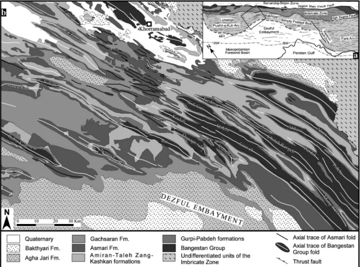
Fold patterns in the Pusht-e Kuh Arc
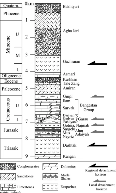
Bakhtyari culmination, marked by a rapid change in the level of exposure along the folds trend. This change in exposure level allows comparing, across a relatively short distance, the characteristics of folds developed within the two carbonate units that form the upper and lower reservoir units throughout the Zagros, i.e. the Bangestan group and the Asmari for-mation. It must be noted that these two carbonate units represent the major competent units in a strati-graphic succession that is otherwise dominated by clastic deposits, shales, evaporites and subordinate pelagic limestones (Fig. 2). The parameters used to analyse fold distribution are the axial length and the wavelength of anticlines, measured from their axial traces. These were obtained from geological maps published by NIOC (National Iranian Oil Company; 1:100 000 scale) and were successively integrated and modified through the analysis of 3D stereo (Spot5) satellite images and field surveys. Axial traces were then sorted in two groups according to the competent carbonate unit in which the fold developed, i.e.
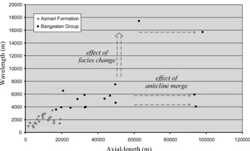
Bangestan group anticlines and Asmari formation anticlines. For each group wavelengths were measured averaging the distance between adjacent axial traces and were then plotted against axial lengths (Fig. 3).
Characteristics of folds in the Bangestan group
link together with the modalities described by Sattarzadeh et al.(2000), generating twists or saddles in the axial traces. By contrast, the few anticlines located to the SW of the Soltan-Rit anticline, namely the Chenareh and Kabir-Kuh anticlines, appear widely spaced and with an axial length above the average of the
main cluster in figure 3. The Soltan-Rit and Kabir-Kuh anticlines also present evidence of thrusting along their forelimbs (Fig. 1), however, field analysis and section construction indicate that the amount of displacement along these faults is very limited, generally inferior to 1 km and not exceeding 2 km (Vergés et al., submitted).
Characteristics of folds in the Asmari formation
The Asmari limestone is an erosion resistant unit that forms the outer shell, or carapace, of many of the folds in the selected area (e.g. Chenareh, Maleh Kuh anticlines). In general a good coupling is observed between the Bangestan group level and the Asmari formation, which is to say: the two units fold har-monically with a parallel style. This is documented, for example, by the deep, pinched synclines that bound on each side the Sardab anticline (Fig. 1). Nevertheless, in the area located to the northwest of this latter fold, the Asmari formation is deformed by tight folds with wavelengths as small as 870 m (aver-age: 2 km) and axial lengths shorter than 20 km (Fig. 3), and by few thrust faults. The presence of short wavelength Asmari folds along the prolongation of large Bangestan group anticlines with a wavelength in excess of 5 km indicates that in this specific area the folds of the Asmari level are decoupled from that of the Bangestan group.
Discussion
The large variability of wavelength and axial lengths displayed by the anticlines of the competent Bangestan group (Fig. 3) can be understood by analysing the Cretaceous facies distribution. Field sur-veys and published paleo-facies maps (Koop and Stoneley, 1982) indicate that the northeastern flank of the Soltan-Rit anticline represents a facies boundary, separating a carbonate platform to the SW from a pelagic area to the NE, with an associated reduction in thickness, of approximately 200 m, from platform to basin. The short wavelength of the anticlines locat-ed to the NW of the Rit anticline reflects, therefore,
the reduced competence and thickness of this pelagic facies and the higher degree of anisotropy induced by the smaller bed thickness and frequent shale partings. Conversely, the greater thickness and higher compe-tence of the carbonate platform facies are reflected by a higher spacing between anticlines and the develop-ment of thrust structures. Furthermore, the higher anisotropy of the pelagic facies influences also the shape of anticlines which frequently display a ‘bullet’ shape (Sepehr et al., 2006), i.e. subvertical, near-iso-clinal fold limbs, with a pointed crest region. This fold shape implies necessarily the existence of a detachment horizon in the Lower Cretaceous Garau shales underlying the Bangestan group (Fig. 2). Regarding the variation in behaviour of the Oligocene Asmari limestone, from perfectly coupled with the Bangestan group to completely decoupled, two hypotheses can be made. One possibility is that a local, shallow detachment exists in the units underly-ing the area of short wavelength Asmari anticlines; the other is that the two competent units fold disharmon-ically due to an increase in the thickness of the incom-petent units separating them, causing the Asmari for-mation to exit the zone of contact strain of the Bangestan group (Price and Cosgrove, 1990). To test this second hypothesis over 300 thickness measure-ments where conducted on the stratigraphic units interposed between the two carbonate units. Thickness measures were carried out using 2.5 m res-olution Spot images and a 25 m resres-olution DEM. Field based control measures indicate that these remotely sensed measures have accuracy in the range of 5-15 %. The stratigraphic unit displaying the largest thickness variations is the Amiran formation, a clastic wedge formed by shales and sandstones derived from the erosion of obducted ophiolite and
ite nappes (James and Wynd, 1965; Homke et al., in press). The Amiran isopach map constructed with this thickness database indicates that the largest thickness-es, in excess of 1100 m, are reached in the area corre-sponding to the short wavelength Asmari folds. On the other hand, the hypothesis of a local detachment underlying the area of short wavelength Asmari folds appears unlikely for two reasons. Firstly, for of the lack of suitable lithologies (e.g. shales, evaporites) in the units immediately underlying the Asmari lime-stone (Fig. 2), and secondly, because the coincidence of the hypothetic detachment with the area of docu-mented increase of the Amiran thickness appears improbable.
Conclusions
Fold patterns of the southern Lurestan region, expressed in terms of axial-length and wavelength distribution, reflect the characteristics of the
sedi-mentary multilayer in which they formed. Within the carbonate deposits of the Bangestan group the transition from pelagic to neritic facies determines a threefold increase in anticline spacing and may be associated with the development of thrust struc-tures in the forelimb of anticlines. The shape of anticlines within the pelagic facies indicates that the underlying Garau shales behave as a detach-ment horizon. The Oligocene Asmari formation folds harmonically with the Bangestan group, except in the areas where the Paleocene Amiran for-mation exceeds 1100 m of thickness. In these areas the Asmari limestone displays short wavelength folds indicating a complete decoupling from the folds of the Bangestan group. It is suggested here that this decoupling occurs because the summed thickness of the incompetent units which separate the two competent units exceeds the thickness of the zone of contact strain of the Bangestan group folds.
References
CARRUBA, S., PEROTTI, C. R., BUONAGURO, R., CALABRÒ, R., CARPI, R. and NAINI, M. (2006): Structural pattern of the Zagros
fold-and-thrust belt in the Dezful Embayment (SW Iran). Geol. Soc. Am. Spec. Pap., 414: 11-32.
COLMAN-SADD, S. P. (1978): Fold development in Zagros simply folded belt, southwest Iran. AAPG Bull., 62: 984-1003.
GOLONKA, J. (2004): Plate tectonic evolution of the southern
margin of Eurasia in the Mesozoic and Cenozoic. Tectonophysics, 381: 235-273.
HOMKE, S., VERGÉS, J., GARCÉS, M., EMAMI, H. and KARPUZ, R. (2004): Magnetostratigraphy of Miocene–Pliocene Zagros foreland deposits in the front of the Push-e Kush Arc (Lurestan Province, Iran). Earth Planet. Sc. Lett., 225: 397-410.
HOMKE, S. J., VERGÉS, J., SERRA-KIEL, G., BERNAOLA, M., GARCÉS, R., KARPUZ, I., SHARP, M., GOODARZI, H. and VERDÚ, I. M. (in press): Late Cretaceous-Paleocene formation of the early Zagros foreland basin: biostratigraphy and magnetostratigraphy of the Amiran, Taleh Zang and Kashkan sequence in Lurestan Province, SW Iran. Geol. Soc. Am. Bull.
JAMES, G. A. and WYND, J. G. (1965): Stratigraphic Nomenclature of Iranian Oil Consortium Agreement Area. AAPG Bull., 49: 2182-2245.
KOOP, W. J. and STONELEY, R. (1982): Subsidence history of the
Middle East Zagros Basin, Permian to Recent. Philos. T. Roy. Soc. London, Ser. A, 305: 149-168.
NATIONALIRANIANOILCOMPANY(1966): Geological compilation map; Sheet No. 20825E: Kuh-e Asmari, scale 1:100 000. Geology and Exploration Division, Tehran, Iran.
PRICE, N. J. and COSGROVE, J. W. (1990): Analysis of Geological Structures. Cambridge University Press, 502 pp.
SATTARZADEH, Y., COSGROVE, J. W. and VITA-FINZI, C. (2000): The interplay of faulting and folding during the evolution of the Zagros deformation belt. In: J. W. COSGROVEand M. S. AMEEN
(eds): Forced folds and fractures, Geol. Soc. London Spec. Publ., 169: 187-196.
SEPEHR, M., COSGROVE, J. W. and MOIENI, M. (2006): The impact of cover rock rheology on the style of folding in the Zagros Fold-Thrust Belt. Tectonophysics, 427: 265-281.
SHERKATI, S., MOLINARO, M., FRIZON DE LAMOTTE, D. and LETOUZEY, J. (2005): Detachment folding in the Central and Eastern Zagros fold-belt (Iran): salt mobility, multiple detach-ments and late basement control. J. Struct. Geol., 27: 1680-1696. VERGÉS, J., KARPUZ, R., EFSTATHIOU, J., GOODARZI, H.,