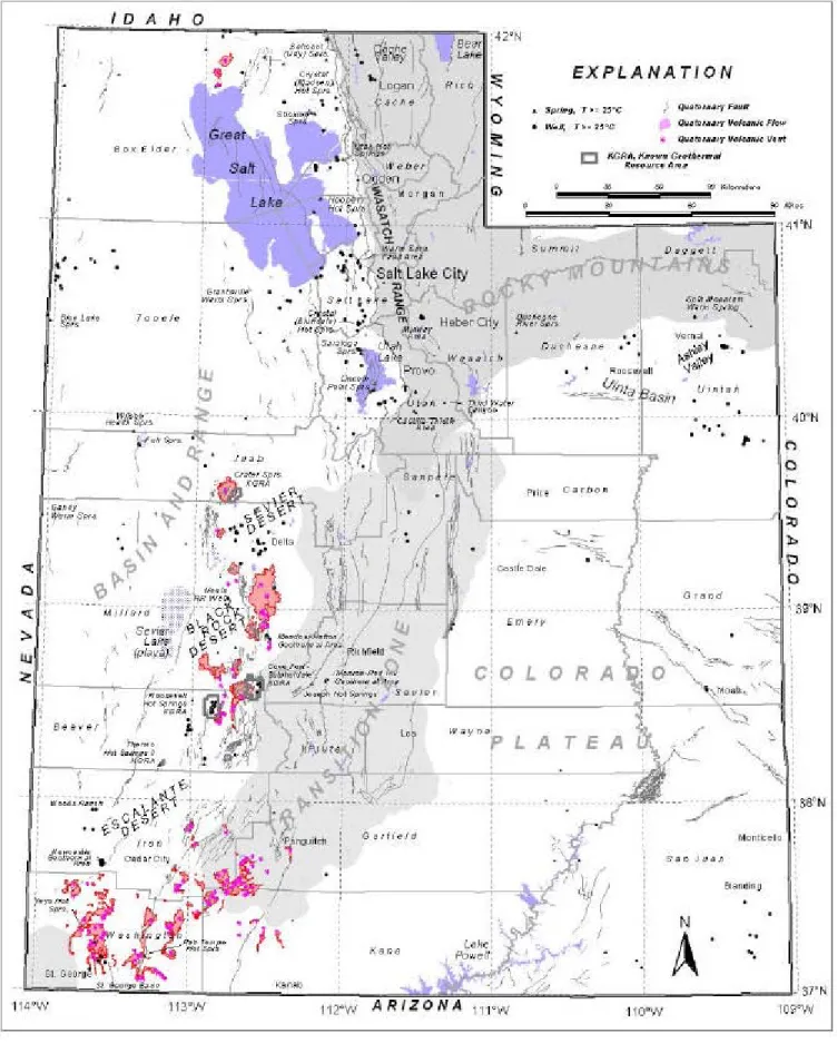
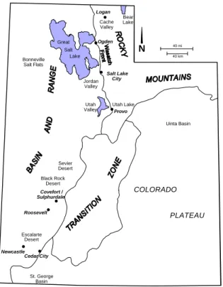
Essentially, the extensive tectonics of the Basin and Range are superimposed on the adjacent, contemporaneous, uplifted blocks of the Colorado Plateau and the Middle Rocky Mountains. The application of the Na-K-Ca geothermeter in thermal areas of Utah and the Imperial Valley, California. Geothermal, v.
CLEANED UP AND CLEANED OUT
RUINED HOT SPRING RESORTS OF UTAH -
The Washington County Water Conservation District pipeline runs through the Virgin River near the hot springs. Historic photograph of the LaVerkin (Tempe) Hot Spring Pool (above; used by permission of the City of LaVerkin).

ELECTRIC POWER GENERATION IN THE ROOSEVELT HOT SPRINGS AREA
THE BLUNDELL GEOTHERMAL POWER PLANT -
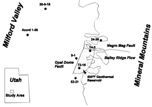
The waters are described as dilute sodium brine, and analyzes of samples from wells and springs indicate that they originate from a common reservoir. Groundwater is mainly supplied to the geothermal reservoir by runoff and snowmelt (meteor water) from the western slopes of the Mineral Mountains. Over these faults, upward flow occurs at the highly fractured intersection of the Opal Dome and Negro Mag grabens and other low-angle faults, providing a geothermal fluid reservoir.
UP&L first generated commercial electricity in 1981 using a 1.6-MWe two-phase turbine research unit installed on one of the wells. The brine layer on the inner wall of the rotary separator passes through holes to an outer fluid turbine whose shaft is connected to a generator. A photograph of the slide-mounted unit installed at the Blundell site is shown in Figure 6.
A hydrothermal model of the Roosevelt Hot Springs area, Utah, USA." Proceedings of the 15th New Zealand Geothermal Workshop, Vol. Conceptual geological model and native state model of the Roosevelt Hot Springs hydrothermal system." Proceedings of the 16th Workshop on Geothermal Reservoir Engineering, Stanford University, Stanford, CA. An overview of the geology and geochemistry of the Roosevelt Hot Springs Geothermal System, Utah, in "Utah in Cenozoic Geology and Geothermal Systems of Southwestern Utah." R.

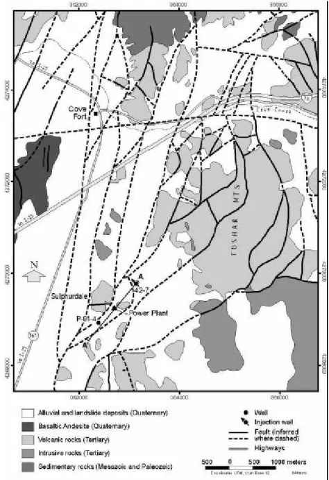
THE COVE FORT-SULPHURDALE, UTAH GEOTHERMAL FIELD
The CFS KGRA lies near the junction of the Pavant Range and Tushar Mountains on the eastern edge of the Basin and Range Province (refer to Figures 1 and 2). The sedimentary rocks of the CFS area are part of a broad, north-trending thrust belt that was deformed during the Late Cretaceous Sevier Orogeny. Simplified geologic map of the Cove-Fort-Sulphurdale area (modified from Steven and Morris (1981) and Ross and Moore (1985)).
Thrust faults can be widely distributed at depth in thermal zone reservoir rocks. Continued activity is indicated by fault scarps in the alluvial and lava flows of the Cove Fort basalt field (Steven and Morris, 1981) and by a high level of microearthquakes in the vicinity of Cove Fort (Smith and Sbar, 1974). Here, in Sulphurdale, and along the western border of the Pavant range, the trends of.
All production wells and all but one of the thin holes produced steam from the Talisman quartzite. Geology of Cove Fort-Sulphurdale KGRA, "University of Utah Research Institute, Earth Sciences Laboratory, Report 18. Geologic Map of the Fort Cove Quadrangle, West-Central Utah," United States Geological Survey, Report of open file, 81-1093 .
CRYSTAL HOT SPRINGS - SALT LAKE COUNTY
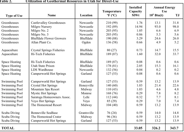
To provide space heat in winter, wastewater from approximately 140EF (60oC) is reheated using natural gas boilers to approximately 180EF (82oC) and circulated through that additional space before being discharged on its way to Hi-Tech Fisheries further downstream. Hi-Tech is a contract operator on behalf of Utah Corrections Industries, a company of the state prison system. Hi-Tech Fisheries uses runoff from Bluffdale Flowers and from the prison's geothermal facility to feed Crystal Pond, which is also supplied by artesian springs.
The discharge water from Bluffdale Flowers leaves that facility at approximately 140EF (60oC) and travels through an 8-inch succession. 20cm) pipes, open ditches and periodic ponds before arriving at Hi-Tech at an acceptable temperature of approximately 80EF (27oC). In the past year, Hi-Tech also reports that combined inflows into Crystal Pond have fallen by approximately 50 percent from average years, resulting in the. As a result, Hi-Tech currently recirculates its own drain water back into Crystal Pond to maintain an adequate supply to the aquariums.
Currently, approximately 200 gpm (13 l/s) of geothermal outflow from the prison goes directly to Hi-Tech. Approximately 450 gpm (28 l/s) of geothermal runoff flows from Bluffdale Flowers to Hi-Tech, although an unknown amount is lost to evaporation and seepage along that path. Hi-Tech does not directly measure the combined total of inflows into Crystal Pond from these various sources.
MILGRO GREENHOUSES NEWCASTLE, UTAH
Geothermal fluid reaches 125EF (52oC) at a church building in Newcastle, located on the eastern edge of the geothermal resource, circulating geothermal water for space heating. Studies have defined a shallow, unconfined aquifer that channels the outflow of geothermal fluids into the subsurface of the Escalante Valley. A maximum temperature of 266EF (130oC) was measured in a 1981 geothermal exploration well that penetrated the upper edge of the geothermal aquifer outflow plume.
Long-term decline of the water table may have accelerated during drought conditions now in their sixth year. If so, regional drought conditions may indeed account for much of the 90 ft (27m) total head lost since 1990. The Utah Geological Survey (UGS) was unable to install monitoring equipment in any of the existing Milgro wells. wells due to potential entanglement of cables and probes.
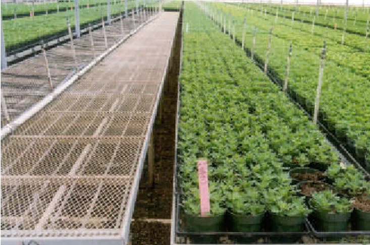
Additional study would be required to determine the size of the reservoir and the permeability of its structure. The initial design of the greenhouse production system was based on the use of plate heat exchangers to isolate the radiant heating pipe from the geothermal fluid. Similarly, maintenance of the shade fabric system is carried out in winter when shading requirements are low.
CASTLEVALLEY GREENHOUSES, NEWCASTLE
Two smaller minima of -44 mV and -36 mV were also mapped to the southwest, above the buried Antelope Range fault. Numerical models of dipole-dipole drag profiles resolve nearly vertical bodies of low drag (4 ohm-m) interpreted as updraft zones. A low resistivity layer (4 ohm-m) at a depth of about 45 m in the alluvium extending northwestward is interpreted as the geothermal outflow plume.
A case study of the Newcastle geothermal system, Iron County, Utah. Utah Geological Survey Special Study 81, 30 p. Thermal regime of the Escalante Desert, Utah, with an analysis of the Newcastle geothermal system. Journal of Geophysical Research, v. Determination of Flow Plume and Fluid Outflow by Resistivity and Self-Potential Data, Newcastle Geothermal Area, Utah." Transactions of the Geothermal Resources Council, v.14, p.
BELMONT (UDY) HOT SPRINGS
Geothermal Investigations in Selected Thermal Systems of the Northern Wasatch Front, Weber and Box Elder Counties, Utah.” Utah Geological and Mineral Survey Report of Investigations 141, Salt Lake City, UT.
UTAH HOT SPRING AND
ALLAN PLANT COMPANY GREENHOUSES
The hot springs were on the Hensley/Salt Lake Cutoff emigrant route used in the 1850s. Special trains were run from Salt Lake City and Ogden to the resort while it was in use. They are deep red from the iron oxide that precipitated from the water. Water, at a rate of approximately 100 gpm (6.3 L/s) is collected at this point for the greenhouses operated by Allan Plant Company.
Water enters the greenhouses at about 135oF (57oC) and supplies heat to the plants through PVC pipes under the tables, then exits at about 90oF (32oC). This radiant heat keeps the greenhouses at the desired 60 to 65oF (16 to 18oC), and the heat is needed year-round, as the sand beds need heat in the summer for seed propagation. Due to the high iron content in the water, special connectors are installed at the bottom of the heating pipes.
Determination of uranium in source rocks using radium at Crystal Springs, Great Salt Lake Area, Utah. US Geothermal Investigations in Selected Thermal Systems of the Northern Wasatch Front, Weber and Box Elder Counties, Utah.” Utah Geological and Mineral Survey Report 141, Salt Lake City, UT. Surface Geologic Map of the Brigham City Segment and Adjacent Portions of the Weber and Collinston Segments, Box Elder and Weber Counties, Utah,” U.
CRYSTAL (MADSEN) HOT SPRINGS
Geothermal Investigations at Crystal Hot Springs, Salt Lake County, Utah.” Utah Geological and Mineral Survey Report of Investigation 139, Salt Lake City, UT.
MIDWAY AREA, WASATCH COUNTY
The large travertine mound is 17 meters high and has a diameter of 17 meters by 122 meters, with a large hole in the top, which was the original entrance - just like a volcano. It was originally used for irrigation in 1890, and for hot tubs made from railway sleepers by boring an 8-inch drainage tunnel through the 110-foot-thick walls. This drainage stopped the formation of the cone - which was originally called 'Schneitter's Hot Pot' after the original Swiss family who settled there in 1864.
Ownership changed hands over the years, and in 1995 a large tunnel was built to allow the 65-foot (20 m) deep pool at 95°F (35°C) to be used as a SCUBA diving certification site. Water draining from the pool through the 8-inch (20 cm) diameter pipe drains into a fish pond adjacent to the Homestead Resort where koi fish are raised. This geothermal area started as a homestead in the Midway area, became a business in 1875 and a resort in 1890; making it one of the oldest resorts in the state.
Geothermal water is used directly in the pools, where the water is changed twice a week. Geology, Characteristics, and Resource Potential of the Low-Temperature Geothermal System Near Midway, Wasatch County, Utah.”.
MONROE-RED HILL HOT SPRINGS - MYSTIC HOT SPRINGS RESORT -
The Monroe-Red Hill Hot Spring area is located 10 miles south of Richfield in Sevier County. The owners have named the resort "Mystic Hot Springs" and offers a geothermally heated swimming pool, therapeutic baths, camping facilities and tropical fishing ponds. Monroe and Red Hill Hot Springs issue at about 170°F (77°C) near the surface trace of the Sevier fault adjacent to the Sevier Plateau.
Geothermal water flows from travertine mounds behind the Mystic Hot Springs Resort at 168oF (76°C) and 200 gpm (13 L/s). The resort offers campsites, RV hookups, pioneer cabins, and typical and tropical fishing ponds. Six tropical fish ponds are maintained at 75oF (24°C) annually, where Koi, Mollies, African cichlids and fancy guppies are raised.
High-temperature geothermal resources of Utah, Utah Geological and Mineral Studies Bulletin 123, Salt Lake City, UT. Moore (editors), Cenozoic Geology and Geothermal Systems of Southwestern Utah, Utah Geological Society Publication 23, Salt Lake City, UT.
ST. GEORGE BASIN GEOTHERMAL AREA