Required Metro Infrastructure in a Fragmented City
The case of Villa el Salvador and its Metro Station
A Thesis submitted in the Partial Fulfillment for the Requirement of the Degree of Master of Science in Integrated Urbanism and Sustainable Design
by Hector Flores
Supervised by
Prof. Dr. Yehya Serag Professor of Urban and
Regional Planning Ain Shams University
Prof. Dr. Leonie Fischer Professor of Landscape Planning and Ecology University of Stuttgart
Prof. Ing. Carlsten Vellguth Professor of Integrated Urban
Planning and Design Ain Shams University
August 2020
Examiners Committee Title, Name & Affiliation
Prof. (external examiner) Professor of (…) University of (…) Prof. (Title/Name) Professor of (…) University of (…) Prof. (Title/Name) Professor of (…) University of (…) Prof. (Title/Name) Professor of (…) University of (…)
08/30/2020
Signature
required Metro Infrastructure in a Fragmented City
The case of Villa el Salvador and its Metro Station
A Thesis submitted in the Partial Fulfillment
for the Requirement of the Degree of Master of Science in Integrated Urbanism and Sustainable Design
by Hector Flores
Supervised by
Prof. Dr. Yehya Serag Professor of Urban and Regional Planning Ain Shams University
Prof. Dr. Leonie Fischer Professor of Landscape Planning and Ecology University of Stuttgart
Prof. Ing. Carlsten Vellguth Professor of Integrated Urban Planning and Design
Ain Shams University
This dissertation is submitted to Ain Shams University (ASU) and University of Stuttgart - Faculty of Architecture and Urban Planning (USTUTT) for the degree of Integrated Urbanism and Sustainable Design (IUSD), in accordance to IUSD-ASU regulations.
The work included in this thesis was carried out by the author during the period from February - August 2020.
The author confirms that the work submitted is his/her own and that appropri- ate credit has been given where reference has been made to the work of others.
Any disputes regarding the copy right of the content is the sole responsibility of the author.
Ain Shams University holds the right to publicly distribute this thesis in the current university standard format. The author holds the right to publish the content in any other format.
08/30/2020 Hector Flores
Signature
I want to start thanking my family, without them this company would have been impossible to realize. Thank each of my friends, who in every conceivable way have shown me their support and accompanied me in this adventure to give all our efforts to improve the future.
To my supervisors, Prof. Dr. Yehya Serag, Prof Dr. Leonie Fischer and Prof.
Ing. Carlsten Vellguth, for all their advices and guidance to develop the starting problem. I would like to mention my professors and urban specialists from Lima, since without them I would not have chosen this path, Dr. Mariana Alegre and Arch. Enrique Alegre, thank you for your training from work and studies, as you helped me form the beginning of this urban experience. To all those I met while conducting this research in Villa el Salvador, since they supported me by sharing their stories and perspectives in very difficult times for the country. Also to Prof.
Michel Azcueta for his time and to continue his struggle for this great district that makes up the capital of Peru. At the same time, I would like to thank all the team that composes IUSD, in Germany and Egypt, for their constant assistance and lessons.
Finally, I want to thank all of us at Intake 8, thank you for each of the discussions, agreements and experiences and for your continued help and support throughout this program. Thank you for all the moments we shared and looking forward to seeing what comes next.
The current situation in Lima according as what we can read in the news and charts is very promising. Reduction of poverty level, a new politic panorama, social movements asking for reforms on the streets. This scenario presents an active country that is considering its difficulties for its progress. Nowadays, cities are measured by their economic strength, but the city’s protagonists, the people, are often left out.
In Lima there is a diversity of cultures and individuals settled in an unequal space, and the solution is not clear since only extensive and complicated solutions are sought. Focusing on particular problems and not transversal ones that affect each fragment. Neighbourhoods are the roots of the city and strengthening their interaction is necessary to clarify their impact. It is here that the new subway system assumes significant responsibility. After 34 years of struggle, Lima has now one line running that is joining two very populated and important parts of the city. Giving the opportunity for this fragments, to coherently work together or to negate one from another. This master thesis aims to find the impact and further scenarios of the metro system and its metro stations around the fragmented city of Lima. Taking a sociological approach, it will encourage the analysis of other fragments in the city. Taking into account the correlation and the autonomy of the actors under study. Also this research would attempt to glimpse an integrative solution for districts that comprise Lima, a city loaded with different nuances and specific visions that must be taken into account for their development. This proposal longs to be constantly discussed and debated by the city’s actors, as a tool to reinterpret the ongoing and future challenges of disparity and disaggregation on the centralized capital of Peru.
Keywords: scale, neighbourhood, city, fragmentation, polarization, mobility, infrastructure, vision, impact, urban transformation, metro
1 1.1 1.2 1.3 1.4 1.5
2 2.1 2.1.1 2.1.2 2.1.3 2.2 2.2.1 2.2.2 2.2.2.1 2.2.2.2 2.3
3 3.1 3.2
3.3 3.4 3.5
17 19 21 22 23 25
27 27 29 30 31 34 34 36 36 37 38
41 42 49
58 62 67 Introduction
Problem statement
Research aim and objectives Research questions
Research methodology Limitations
Theoretical Framework on Mobility infrastructure Infrastructure conceptualization
Infrastructure, a continuous political problem The role of transport infrastructure
Reinterpreting urban mobility City fragmentation
Individual identity formation
Plurality of identities in urban development Participation involvement
Connectivity interaction
Infrastructure fragmentation relationship
City review
City scale, a larger interpretation of Lima
District scale, an interrelation between the government and the neighbourhood
Urban mobility in the city development
Corona virus pandemic sharpens informality and lack of mobility infrastructure
Towards a new interpretation in the city
4.1 4.2 4.3 4.3.1 4.3.1.1 4.3.1.2 4.3.1.3 4.3.1.4 4.3.2 4.3.3 4.4 4.4.1 4.4.2 4.4.3 4.4.3.1 4.4.3.2 4.4.3.3 4.5
5 5.1 5.2 5.3 6
69 70 74 74 74 77 79 83 84 87 88 88 90 94 94 95 98 101
105 105 106 107
109 Data presentation
General characteristics of the sample Social Facts
Outcomes of living in the district Relationship level
The best aspects in the district
What is currently affecting the district Saving capacity
The problem of insecurity
Good relationship vs very insecure perception Infrastructure impact
Infrastructure presence in the district Requirements in the district
Metro system perception in the district Mobility in the district
Relations of the Metro de Lima and the district improvement Improvements required in the Metro de Lima
Vision in Villa el Salvador
Discussion
Infrastructure refreshed interpretation An articulated system for urban mobility Identity interaction
Conclusion
18 20 24 38 39 42 44 45 48 49 50 53 57 60 61 63 65
70 71 72 73 75 76 77 79 Figure 1
Figure 2 Figure 3 Figure 4 Figure 5 Figure 6 Figure 7 Figure 8 Figure 9 Figure 10 Figure 11 Figure 12 Figure 13 Figure 14 Figure 15 Figure 16 Figure 17
Figure 18 Figure 19 Figure 20 Figure 21 Figure 22 Figure 23 Figure 24 Figure 25
Estimations of travels in the Metro Line 1 in rush hour Metro Line 1 in the city scale and in the district scale Research methodology plan
An interactive model of (social) identity formation Users as transformers to decide their future
Rivers and channels that formed the development of Lima Highways and main streets in Lima
From informal settlements to districts that form Lima Current distribution of metropolitan Lima
Push and Pull factors that motivated the migrants First invasion and resettling of the community
From the first settlement to the current status of the district Stages of the community through the decades
How the citizens of Lima mobilize to their work Urban movements for work using motorized means
Socio-economic strata in Villa el Salvador and negative outcomes due to Covid-19 pandemic
Epidemiological traffic light according to the weekly number of positive cases
Gender and age groups percentages Education level
Civil state status
Working and residency status and its presence in the district How is the relationship formed with the district
Good relationship according to the status of residence The best features recognized by the community New facilities in Villa el Salvador as perceived
83 84 85 87 88 89 93 94 96 97 100 102 107 Figure 27
Figure 28 Figure 29 Figure 30 Figure 31 Figure 32 Figure 33 Figure 34 Figure 35 Figure 36 Figure 37 Figure 38 Figure 39
Saving capacity level of the respondents in the district Insecurity perception levels in the district
Highest insecurity level according to general characteristics Strategic objective to deal against insecurity
Highest insecurity perception against good relationship Facilities that residents find closest to home
The requirements shared by the residents for Villa el Salvador Hours expend in commuting per day
Metro improvement level in the district
In district improvement VS fragmentation improvement Requirements to improve the Metro for the district Visions shared by residents in Villa el Salvador
3 steps to reinforce the vision, to develop the fragments of the city
Picture 1 Picture 2
Picture 3 Picture 4 Picture 5
Picture 6 Picture 7
Picture 8
Picture 9 Picture 10
Picture 11 Picture 12 Picture 13 Picture 14 Picture 15
Picture 16 Picture 17 Picture 18
District culture movement and the metro line in the background The metro passing above a commercial area in the centre of Lima
The bridge of the discord that attempts to unify but avoids the connection between two districts in Lima
Combis in Lima respond to a necessity to move in an affordable mode to drivers
Resident placed a wood workshop infrastructure on the street Arrival of public lighting to the district of Villa el Salvador Huatica channel taking part to the community of Barrios Altos in the centre of Lima
Informal settlements, a opportunity for the development of the city
Arrival to the assigned land in Tablada de Lurín
Boulevard del Cuero, located on the avenue that leads to Villa el Salvador metro station
Variety of commercial activities in IPD area House located in CDD area
Centre for Care and Isolation Covid-19 in Villa el Salvador Sidewalk in front of the metro station
The side facing the industrial park of Villa el Salvador metro station
Informality around Villa el Salvador
Mototaxis around Villa el Salvador metro station
Panels in the subway station in Lima Centre providing knowledge about dangers in their use
16 26 31 33 35
40 43 46
51 54
56 56 66 68 82
91 104 108
Villa el Salvador
Metro de Lima
Metro system
Line 1
Invasion
This term refers to the entire current district with emphasis on the population within the district. Villa el Salvador belongs to South Lima and is one of the 51 districts that make up the current city of Lima. Its name means people of the savior, it has a religious connotation where the savior is Jesus Christ, from the Catholic vision.
This phrase refers to the subway that is in operation (line 1) and involves all the future extension of the following lines to be built. It is a holistic definition of the whole project, as its material form that is recognized by the users.
This refers to the metropolitan railroad system that covers the city of Lima. It directly involves the entities in charge of its operation. In turn, the basic network of the Metro de Lima, which makes up the legal framework that allows the development of studies to raise the following lines.
Line 1, is the only line that is in operation of the Metro de Lima.
It runs from the centre of Villa el Salvador (South Lima), to the centre of the city and to the district of San Juan de Lurigancho (located in East Lima).
It refers to the informal settlements that occur in the city of Lima, starting with an illegal occupation of the land. They lack basic services and urban infrastructure (Habitat III definition)
Currently, cities around the world are constantly struggling to excel each other.
An important factor in improving and achieving a better citizen’s position is and has always been infrastructure. Such infrastructure, in all its presentations, appears as a necessary and perennial element to guide the development of each city, with a complex system that reflects the city where it is located (Graham, 2009). Although sometimes this factor does not benefit all city residents. The infrastructure that enables social and economic mobility, in many cities has acted in different ways. In some parts of the world, infrastructure systems are applied with the function of enabling the activities of economic agents to develop, promoting growth that benefits society (Buhr, 2013). However, in Lima, the opposite has happen. While the city has developed, without planning, in a large desert area conditioned only by its hills, Peruvian resourcefulness has always been set as a self-sustaining solution for communities. This has naturalized a distancing from the government with its inhabitants, conditioning that the population is not taken into account. Therefore, a future vision becomes a transversal problem of rulers and city, where the former do not pose one and the latter are not heard for an urban transformation.
Taking into account that the functionality of cities depends largely on urban mobility, in which the movement of resources and the economy takes place.
The Covid-19 pandemic, which so far the way to combat it is through social distancing and quarantine, makes Lima’s future uncertain. A city that has grown up disjointed for decades is affected to a greater extent since many of its activities depend on urban mobility. It is precisely in the city that an unequal confrontation with this virus is observed, while mobility has been reduced, making it necessary to reinterpret activities and recover the neighborhood scale (Espinoza, 2020).
In Peru, Lima is currently the epicentre of the pandemic, and
while in the consolidated parts of the city it is possible to stay at home and work in virtually all of the fragmented city, this is not possible. People living from day to day life now find themselves deciding between dying from the virus and dying from hunger, where an estimated 70% of the population lives this way (Clarin, 2020). Since the World Health Organization declared the global pandemic on 11 March this year (WHO, 2020), the disease has been consistently minimized by much of the population in Peru. The collapse of the health system in the country has led to a late realization of the consequences of this outbreak. And this is a problem that reflects the disconnection between society and the experts.
A city with better infrastructure and more connections, is presented as a more competitive place and that consequently will host a better quality of life. However, in the global south, cities have to choose between a better economic status and improving their quality of life. In these cities, subway services are being promoted that try to integrate and reorder the city, joining the Latin American ecosystem of
Figure 1. Estimations of travels in the Metro Line 1 in rush hour. Source: author based on data presented in the Master Plan for Urban Transport in the Metropolitan Area on Lima and Callao (PMTU 2025).
mass transport (Albiser, 2020). Lima presents the same idea, but in a particular way. The only functioning metro line in the city connects two fragmented districts that currently have the highest number of trips in rush hour, according to future projections to 2025 (JICA, 2013; PMTU Master plan for urban transport in the metropolitan area on Lima and Callao, 2005).
Although these two districts have many similarities like those mentioned above, they also have several particularities that mark social differences in the city (both districts have problems of citizen insecurity and are considered popular districts that grew due to internal migrations because of the economical crisis in the country). Villa el Salvador is one of the first districts with its development due to community self-management. Although since its beginnings, the community has managed its own development, at present there is a growing sense of not feeling part of the city, due to the low socio-economic status and the remoteness of central and developed Lima.
1.1 Problem Statement
These disjointed districts are the components that have formed the city of Lima in its years of history and irregular growth. The disjointed districts are the components that have formed the city of Lima in its years of history and irregular growth, becoming a norm in the expansion of the city. This heterogeneity has complicated a comprehensive understanding of the city. To date, Lima has 50 districts, each with its own mayor and urban policy, making integrated city planning difficult. At the same time, different nuances appear conditioning a disintegrated development. The city is densifying at great speed recently, and this growth is occurring to a greater extent in the areas away from the city centre or cardinal Lima. Places where there is less infrastructure and more poverty.
After a difficult journey, Lima now has a metro system, of which one line is
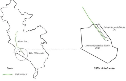
running in the city. This metro is an important opportunity to connect different parts of Lima. But considering the scale of this project, this district was never prepared to receive this improvement which was stopped for many years, leading to an uneven development of the two segregated parts. The upper part of the district (IPD) has developed a strong economy due to the industrial zone that has been connected to Pachacutec Street, an important artery that connects all the southern districts of Lima. Having now a part of the district with a diverse economy; while the lower part of the metro line (CDD) has not developed as well, finding a district that requires a long road for development.
A current problem is that Lima is not prepare to face the lack of infrastructure currently affecting the city. Mainly due to underestimating the requirement of the people that this master thesis tries to reveal from the visions of the people. Lima has been accustomed to fix problems. Taking away from the city a necessary vision that can sustainable manage its upcoming challenges. The measures only fix the present, overlooking the immediate problems to come. From here we recognize the transversal problem that involves all areas of the city, the lack of vision in the city.
Figure 2. Metro Line 1 in the city scale and in the district scale. Source: author.
Now in Lima, a new normality is proposed to be taken after the pandemic is overcome.
This is where urban mobility has to be rethought in order to function in these new circumstances, while a structured informality extended across the city should be included. In the case of Villa el Salvador and many other parts of Lima, transportation is still largely informal. This informal or unregulated transport is the main agent that allows urban mobility in the city. While formal urban transport where its use can be controlled still does not represent more than 10% of use in the whole city (Lima Cómo Vamos, 2019).
1.2 Research aim and objectives
As mentioned, Lima is now in the process of implementing an integrated subway system throughout the city. To date, the first line of the Metro de Lima is in operation, while its functionality for the population has not been fully understood. This is why it is relevant today to understand the social impact of the integrated transport system in one of the fragments that form the country’s capital. The research is aimed at understanding the different factors that involve the infrastructure in a fragmented city, as well as what is missing for people to leave the comfortable informality and involve the formal system in their lives. At the same time, the research also intends to discover different challenges that will appear soon, taking into account that this transportation system will integrate different parts of the city that may have certain similarities with Villa el Salvador.
Leading this research while the Covid-19 pandemic continues to spread around the world, where it is observed that it is sharpening the inequalities present in the city, makes this precise moment to take a stand on this problem that has been living for years normalized in Lima.
To reinforce the focus of the research, it is proposed to investigate the issue by reviewing the literature and collecting field data, for which the following objectives will also be addressed.
- To rethink the uneven development of the city and its consequences in a district affected by different layers,
- Understanding the fluctuating Metro de Lima implementation process and factors to be considered,
- To build a framework to be capable of analyzing future challenges in fragmented areas,
- To understand people’s vision and their relationship with the metro system to be implemented in the city,
- To explore the underlying factors and consequences for the future of young towns in Lima,
- To reinterpret the panorama of the city, according in the requirements and visions of the people,
- To recommend strategies to address problems in fragmented areas by taking advantage of the metro infrastructure.
1.3 Research questions
The scope of this research begins by questioning: How will the required metro infrastructure impact the already fragmented city of Lima? Several internal and external aspects arise that involve its planning, execution and most importantly, how it could be used as a tool for development.
To investigate the nuances of the research, the following questions are formulated.
- How is the infrastructure in the city’s fragments working?
- Why does the infrastructure not work well with self-managed neighbourhoods?
- How does stagnant infrastructure exacerbate uneven development in fragmented neighbourhoods?
- What are the reasons that determine the distance from the plan with the population?
- How could an integrative strategy for sustainable mobility be generated in the city?
- How can an integrated transport system help combat the pandemic?
1.4 Research methodology
This research begins by conceptualizing the infrastructure and the fragmentation situation in cities belonging to the global south. It takes into account the problems experienced in the city of Lima for all the components that imply urban development.
After determining the problem, one has to ask what one wants to find in the city and what are the deficiencies in these areas. This implies, given the situation, a constant rethinking according to what can be obtained as indicators.
Proceed with the collection of data, which will be mainly through digital questionnaires to understand the current situation, as well as the relationship with the Lima metro.
Once the results are obtained, they have to be complemented with indicators already studied, in terms of the number of trips, mobilization patterns in Lima and the prevailing relationship with citizen insecurity.
Analise the results obtained, and superimpose them with the social and mobility surveys carried out in the city. To be able to understand which are the gaps, incompatibilities and relations with the concepts raised. This analysis will take into account mainly the relationship between the infrastructure and the citizen.
Define recommendations to reinforce the structural plans in the city so that they can be appropriate for their users, ensuring their maintenance and improvements for the population. In turn, it will take into account how this formal system can be addressed to reactivate the city, giving it a safe and sustainable option for the city, which for many years has had to grow at its own pace.
Figure 3. Research methodology plan. Source: author.
1.5 Limitations
The main limitation found while conducting this research has been found in the people, the reaction of the country to control the pandemic is stop the mobility.
This means for many residents in the city now being able to work for the day and many people is currently struggling to produce the money.
Not everyone have the possibility to do home office, a large amount of people travel many hours from their homes to the workplace, so this new normality has sharpen more the inequalities rooted in Lima.
This are the main limitations found while doing the research:
- Interviews to experts have been limited to phone calls and emails.
- People’s response to online surveys have also been limited. The responses have been brief since not conversation has been possible.
- Another related problem is that as a complex context is occurring, the responses may not reflect the real impact of the transport infrastructure in the city. The most serious problem now in the country is the insufficient health infrastructure and loss of jobs for the population.
- Complementary data had to be obtained from studies and articles that address the same issue but on a broader city scale.
infrastructure
In order to compete in this globalized world, cities must be in constant motion.
Lima is not far behind in this respect, positioning itself as the next megalopolis that will host a large percentage of Latin American economic activity. Cities around the word required to improve their infrastructure to embrace all their activities. This current scenario leads cities is leading cities in LA to improve their transport infrastructure.
This investigation begins by reviewing some concepts, revealing in each one the gaps they may have when investigating them in the Lima context. Aiming to construct a theoretical framework to conduct this research and that allows to comprehensively analyze the problem in the research.
2.1 Infrastructure conceptualization
Infrastructure is a constantly changing term and has received several meanings over the years. As Alehashemi says, Williams defines it with this phrase:
“Infrastructure, like technology, turns out to be a recent term and promiscuous term”, showing the conceptual adequacy of this word (Alehashemi et at, 2017
; Williams, 2002). By understanding this conceptual function in continuous variation, a sense of dependence is interpreted. If we analyze the word by its composition, infra comes from the Latin prefix, below and structure has reference to construction, meaning the foundations or roots of a building that ensure its functionality. If we overlay these two perspectives, a correlation becomes uncertain since foundations do not have a sense of dependence, but rather provide the necessary support to erect a building.
In cities, the function of a city’s foundation is not necessarily provided by its infrastructure. In some cases in LA we have examples of cities that have reinvented themselves through their new structural systems for mobility, gas production or mining (Cáceres, 2016). Of all these examples, it is the users and the activities that remain in place to ensure their functioning. Infrastructure is the starting point while the service is achieve when the users require it to achieve their plans (Cavallo et al, 2020).
Nowadays that the world is urbanizing in a fast pace, the complexity of this object is getting difficult to comprehend (Graham, 2009). Graham also points that the infrastructure are immobilized and always working for the city, under this perspective them can be interpreted as an asset for a city that is there to work for it. That notion can be interpreted when is already placed and working, but it does not explain what happen when it comes after the requirement and is tamper by dissimilar actors. In cities from the global south, where the disturbances and disorders describe the city and where there is a constant requirement to improve (Graham, 2009). Taking this notion of Graham and applying this to the context in Lima, becomes very relevant. Infrastructure improvements have a history of corruption where different stances battle each other continuously. In another hand, the city never had a proper plan to develop. Infrastructure provisions by the government appears as a tool enforce economic growth that also have lead to bribery. Access to infrastructure is determined by the socio-economic status and proximity to urban centres, which in turn increases the price of land according to its proximity to infrastructure (Cavero, 2018; Boullon, 2012). This implies that the infrastructure adheres to its concept a determining factor in the configuration of the city.
In terms of what can be achieved, the infrastructure marks socio-economic strata according to what a certain population can achieve. Isolating categories as opposed to integrating systems for the city.
2.1.1 Infrastructure, a continuous political problem
A tool can range from utensils for mastering a craft to the military’s ability to fight a war, such as a strategy used by the United States in World War II to develop their economy. According to Buhr, the infrastructure is a task for the state and the different actors involved. But nowadays public-private attempts are in motion to facilitate its implementation. Infrastructure has always being a political function (Buhr, 2003). In Peru, infrastructure is a very delicate topic. A wide number of the infrastructure already in the city has been made under corruption or weak materials. But the main problem is the continuity of it. Normally when a new government is set into office, the promised projects at campaign time start to delay. And until the last years, they start to be constructed and never ended by the next government that normally is against the previous political party. That is exactly what happened with the metro system in Lima. Struggles between political actors for insubstantial reasons set aside the requirements of the city and focus only on winning elections, denying promised projects and constantly depriving continuous and focused development.
It is necessary to take into account the determining role that infrastructure represents in urban policies, since these are generated to benefit the requests of the population (Monstadt & Coutard, 2019). But this is difficult in a city like Lima, where there are 50 districts governed by different entities that generate a dis-articulation in integral solutions for the city.In Chile, the Ministry of Housing and Urban Development, since the 90s, bet on a national plan to encourage and support the construction of housing has promoted that they settle in peripheral territories where prices are more accessible and can generate more disintegration (Heinrichs et al, 2013). In Peru, these integral plans have not occurred, and rather, territorial occupation has been determined by self-managed decisions such as invasions and informal settlements (Wiese, 2016; Cole, 1956).
2.1.2 The role of transport infrastructure
The transport system has function over the years as a key player to develop cities across the world. Transport infrastructure plays a major role in development, De Grange captures the impact of the metro system on the number of jobs in cities with and without a rail transport system. Where we see a 15% growth in jobs in cities with a transport system (De Grange, 2010; Partridge, 2007). This is in line with what Vuk verified, which in its analysis of the origin of users who adopt the metro system, indicates that there is 15% new user demand, while the other 85%
is due to mode migrations (Vuk, 2015). According to these notions, the transport infrastructure takes on an important role as a developer of cities, since by changing the system it adds new users. It is not only a change of mode but it gives a new vision to the users. Moreover, due to the homogeneous cost throughout the population allows it to be used by people regardless of their affordability status, improving economic efficiency in the city due to better connectivity and generating more activities by bringing together new economies by agglomeration (De Grange, 2010). It is important to add the role that O’Conell tells us, where people prefer to reside near subway stations, even if these are not used by them, thus there is a relationship not well defined (O’Connel, 2015).
But it must be taken into account that the infrastructure conceives a positive role at its initial point and this can change when it is in operation. This can be seen in the centre of Lima, two districts are now divided by a bridge that tried to unify them providing a public space to the city. But bad municipal management between these two districts has led to it now being called “the bridge of discord”
because of the new fence that restricts free pedestrian traffic (LA Network, 2020).
In this case, the infrastructure began with a clear role and objective, but due to administrative, political and citizen factors, its function contrasted completely. It is imperative to take into account the stakeholders and their respective intentions with the infrastructure in order to manage it and really benefit the citizens.
2.1.3 Reinterpreting urban mobility
Through all this time, mobility is framed as the movement from point to point.
Focusing just on the physical movement, push cities to look in the efficiency of the action. Taking the motorized transport as the most important aspect to focus. But mobility is so much more. As cities have developed and enlarge their dimension, moving from place to place is not more a defined task. According to Vega-Centeno, the complexity of the urban form gives to the city a new setting and frames the time as a crucial element in this activity (Vega-Centeno, 2003).
Nowadays, the activities and vital functions are dispersed in the city, forcing to mobilize in an automobile to cross these new city nodes.
Framing a holistic meaning may be impossible as mobility has many interpretations. According to Costa, Morais and Bertolde, mobility is the ability to move around the city while helping to fulfill a social function in it (Costa et al, 2016). If we take into consideration the complexity that the city is currently
Picture 3. ‘The bridge of the discord’ that attempts to unify but avoids the connection between two districts in Lima. Source: LA Network, 2020.
gaining as mentioned above, moving freely with wide access around the required places can be difficult. Movement in the city requires technology to be more operational and efficient to make this activity real and constant.
Today, Lima is in seventh place in the traffic range of cities around the world.
With an average congestion level of 57% that can reach over 120% at peak hours (Tomtom 2020 traffic data), it appears to be one of the most congested cities and a great challenge to work on. One of the main reasons for the city’s traffic is uneven development. Lima is made up of several parts, which can be characterized in two groups: modern Lima and the urban cones that are unrelated to the former.
This generates daily excess of motorized trips since there is a need to be formed by work and education that normally is in the centre. According to Vega-Centeno, mobility is strongly related to proximity. And this can delimit the use of space by having to include important displacements that demand time and resources (Vega-Centeno, 2003). While Ramirez emphasizes that this is due to the reticular structure that has emerged in an already built city, it has been imposed. Ramirez also characterizes Lima as a dual city, which implies a concentration of resources and services in one sector (Ramirez, 2006). Leaving remote areas lacking the same opportunities. As implied later in his article, spaces that do not constitute nodes and do not generate interest for profit are excluded from the system.
Moreover, in 2017, he emphasizes that it must be taken into account that Lima has been urbanized in a large percentage through informal and illegal occupation.
An occupation system that requires the presence of the state to be established (Ramirez, 2017). The mobilization in the city, therefore, has been done to a greater extent by political actors. And these, in turn, require the citizen mobilization of neighbours to form the social base necessary to strengthen political projects.
Within this framework, Ramirez invites us to have this other perspective. The mobilization is highly related to political projects, which must be integrated from
Given the above, it is understood that common activities are local and a district may not belong to a city system by only moving locally. Now that the city is growing with the vision of becoming a megalopolis, movements have to take place on a new scale that mixes these different existing neighbourhood scales. At the same time, Ramirez takes up Vega-Centeno’s interpretation that the metropolis is a social phenomenon from its base, where centralities are articulated in a network of centres that form the city (Ramirez, 2006). Changing the systems on presented on a city already used to informal transportation can have unexpected consequences.
the beginning. And in this, the levels of the city’s actors concerning their mobility will be affected by their role.
Picture 4. ‘Combis’ (little white buses) in Lima respond to a necessity to move in an affordable mode to drivers and convenient for users since more of these units give more places to reach. Source: Andina, 2020.
2.2 City fragmentation
The term fragmentation is used to refer to various characteristics of a city. Is has been mean to explain the necessity of a new approach for architecture in the city (Martuccelli, 2018), making clear the intrinsic requirement for a new interpretation due to fragmentation. This is a problem of many countries in LA, where they have in common that the cities facing fragmentation are the capitals of these. If we define it from a natural point of view, the fragmentation of habitat has always been present throughout history and in turn, has been required for the species that inhabit the planet, but in a city, it acts differently. Fragmentation is the separation of parts in a common space that is now affecting the environment, making it more difficult to recover (Mullu, 2016 ; Fischer and Lindenmayer, 2007). In a natural environment, fragmentation usually occurs due to human activities and the consequent destruction of the ecosystem. While in the city, fragmentation occurs due to several reasons. In this sense, this research needs to understand the reasons why a city fragments itself. In order to understand social fragmentation we are going to review it on two scales, from individuality and plurality recognizing its problems and reasons for sustaining it. One of the main factors is how to involve different actors in the same vision, as in an urban development project. Another important factor is the requirement of interaction to form a common identity that responds to urban fragmentation.
2.2.1 Individual identity formation
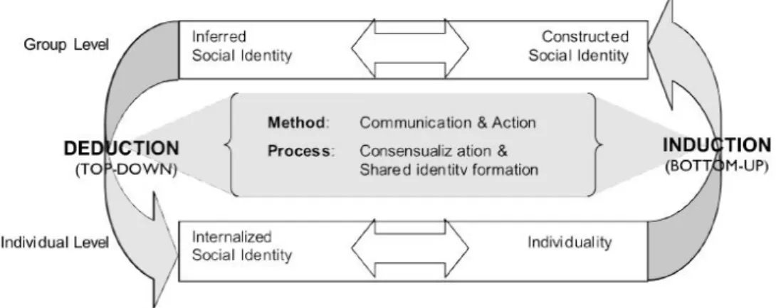
The identity has been formed over the years mainly by the movement of the masses, this occurs in two directions: a vertical one that holds the history and tradition that identifies each individual and a horizontal direction that is determined by the interaction and collective understanding of social reality (Postdem et al, 2006). It can be assumed that identity is formed according to the sense of collective destiny that is achieved through interaction. While history and
tradition are the engines of identity, common vision and issues would be the fuel that feeds the identity. The horizontal factors are a constant need for an identity to be maintained, the context is a determining factor to achieve it. Moreover, it is necessary to underline the importance of the contrast created between the different identities, which is given by human nature to try to differentiate itself from others. According to these notions, we can interpret that a city already differentiated between its parts already conveys different identities already formed, where individuality does not go hand in hand with group mobility. And within this individuality, identity develops through an exchange of horizontal influence that is generated in the relationship with other individualities. There are two ways of understanding identity. It can be conceptualized through the autonomous analysis of individualities, while if one seeks to understand its management, it is preferable to compare it with other similar groups that are understood through social interaction and mobility (Cinoglu et al, 2012).
Picture 5. Resident placed a wood workshop infrastructure on the street near metro station in Villa el Salvador, converting it to a family business. Source: author.
In natural environments, fragmentation has been due to natural factors such as mountain chains or lakes. But in a city like the one analyzed in this research, the reason cannot be natural since Lima is homogeneous in territory, only limited by mountain chains that are now being populated. This research will focus on analyzing a district where there are no natural factors that can determine its fragmentation. Therefore the generation of incompatible identities is due to sociological factors, where the interaction is vital to be able to weave them.
2.2.2 Plurality of identities in urban development
One of the main challenges for urban planning in the future is to balance the needs of the population without compromising environmental sustainability and the resources needed for survival. An important actor in the environment is the people and their differences can be apart from the challenge, their solution.
Professional approaches have always been directed towards proposing a novel solution, contrary to the problem. But as we can understand in medicine, vaccines are created by modifying the virus, using the actor.
2.2.2.1 Participation involvement
Social identity begins with the personal, and these are each of the nuances that form the culture. Although it is individual, it is formed from the collectivity, since it is through the reflection of contrasting ideas in a society that identity is generated (Abrams, 2001). These benefit personally and therefore provide collective benefits to society (Jeannotte, 2003). To ensure these benefits it is important that an interaction between the individual identities takes place.
Social interaction is not achieved with the new infrastructure, since it does not necessarily imply access to it. What can be achieved as a direct consequence is education, capacity building and new opportunities, but more elements are needed
for social interaction. Since infrastructure entails more opportunities for personal development, we can stipulate that this is more related to the approach in which the generation of infrastructure is directed. According to the International Initiative for Impact Assessment (IIIE) report, communities with infrastructure lose interest as the project is located, in what the report calls the attrition funnel. Citizen awareness in the stages of a community development project begins at more than 60 percent in terms of recognition of the idea and progressively decreases to less than 10 percent awareness of its cost. This means that by the time the project is carried out, there is no knowledge of it. The detachment to new projects for the city becomes usual, generating the sensation of not feeling part of the change. Where participation is mainly conditioned by the need that frames the project. If there is no need, it ends up being an infrastructure project disconnected from oneself. The emphasis ends up being on the object but not on the user. Therefore, from this perspective, the use of the object can only be measured when the object is affected, leaving aside the actor and his identity, who uses it and interacts with it. The relationship between need and individual benefits mentioned above becomes relevant in order to reinterpret this synergy between change projects and beneficiaries.
2.2.2.2 Connectivity interaction
The interaction takes place in the urban space, which are spaces that circumscribe the different actors in the city in a group level as passing from an individual level, which is a loop builds knowledge through communication and action (Postdem et al, 2006). This urban space depends on the infrastructure to be able to function integrally for all the inhabitants. This interaction requires the functioning of the city, understanding that a city without infrastructure will have difficulties in doing so. It is also understood that the interaction is generated by its inhabitants since they are the ones who have generated through the years social processes for its improvement (Sousa, 2018).
In the case of Bogotá, the capital of Colombia, which now has a bus system that connects the city, this is an example of how to repair an already fragmented city that was experiencing various social difficulties. Generating a city with the possibility of healing itself through new social interaction This was achieved by not determining the solution of parts, but a comprehensive vision of the city that generated an integral system for all its residents. (Cesafsky, 2017; Castro and Echevarrí, 2011). But it should also be noted that connectivity does not necessarily induce integration. In a city like Lima with so many social differences and an innate need to seek to differentiate oneself from others, integration is limited.
And it is here that the above-mentioned point becomes relevant.
2.3 Infrastructure and fragmentation relationship
The fragments are the result of a whole that contained them. To reintegrate them again, a structure is needed to keep them unified. The infrastructure and the fragmentation present a direct relation to amend and give a platform for social interaction. The role of infrastructure is necessary to set a direction for development. Infrastructure can encourage different reactions apart from urban mobility, in some cases it can stimulate population growth, as well as generate gentrification.
Figure 4. An interactive model of (social) identity formation. Source: Postdem et al, 2006.
While a study conducted by CityLab concluded that metro infrastructure does not necessarily stimulate population growth, because unlike cities in the global south, the urban growth occur before car use and when these cities where at the beginning of their expansion (Florida, 2016). Nowadays, cities like Lima are dependent on the automobile, generating a relationship with the infrastructure after the initial challenge, which is its growth. Having to adapt to it and redraw its development since this factor was not present for its initial development.
Perhaps then, the relationship of the mobility infrastructure is with the activity, as more opportunities for movement are generated more economic activities in the city and around the stations. Possibly, the more mobility axes are attached to Lima, this can generate an economic growth and cultural and urban knowledge exchanges, generating a city that functions as a network, where it determines its growth through information and technological improvements (Castells, 2006).
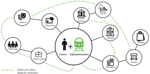
In this sense, users are a key element and the starting point for these growths to occur. Since the users are the generators of the activity, from this perspective it is imperative to delve into what the future visions are and how they can be related to urban mobility (See Figure 5).
Figure 5. Users as transformers to decide their future. Source: author.
This research attempts to tell the story of Lima on two different scales, and while merging these two establishing the perception of the city that this master’s thesis seeks to address. Cities are made by the actors that perform in it, the resources, institutions and economy are the tools but the one that uses it is the people. As years pass by, we are accustomed to measure the city in its economical level or the infrastructure it has, rather than noticing the players that are driven the development in it. Lima is a city without infrastructure that continuously lacks of it. Having different parts that do not relate to each other makes more difficult to address and aim towards its development. Lima is today full of problems, where each of these is reflected in an attempt at solution with little impact. This causes improvements to be inhibited on a smaller scale where this in turn cannot propagate or increase their impact. Normally the city has been thought of from a larger scale in demographic levels while urban studies in social sciences have always focused on the neighbourhood scale. At the same time, this neighbourhood scale is given the prominence in a more complex scenario than the neighbourhood itself. I always try to extend it to higher levels so that isolated strategies are obtained that do not converse with the other sectors of the city.
This master’s thesis will take these two stories at different scales, seeking to relate from a sociological point of view to the different actors who swarm the city.
3.1 City scale, a larger interpretation of Lima
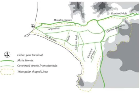
The capital of the country was first conceived to be settled in the valley of Jauja, belonging to the department of Junín. A city in the central highlands of Peru very rich in minerals and culture, where more than 30% of the city’s territory is granted to a mining company. Then being a city in a high altitude, the capital of the country was rethink to be in Lima (Mayma, 2018). As it is located in better conditions in the coast, with a moderate climate, next to the sea for commerce purposes and protected by its cliffs against sea attacks. Lima in its beginnings settled down like a walled city, it was located between three valleys annexing to the Rimac River mainly. This river is born in the altitudes of the Huarochirí region, generating an industrial and mining axis that now connects and establishes the type of Peruvian economy. Lima being a desert had to take advantage of the Rimac River to generate a network of channels aiming to sustain a desert city ensuring agricultural production (this channels began to be built about 2’000 years ago; Lizarzaburu, 2015), which were defining what now the main streets of the city are (See figure 6). Nowadays, the remaining channels still irrigate green areas in the centre of Lima.
Figure 6. Rivers and channels that formed the development of Lima. Source: author based on Canziani publication (Ciudad y Territorio en los Andes: contribuciones a la historia del urbanismo, 2009).
After the fall of the wall, the formation of new districts and the need to set up a better scenario, the development of the city was not planned and was form from several illegal occupations (Facho, 2018; Calderon, 2005). Most politicians came from a military coup without strong ideas of planning or how to structure the challenge (The state’s capacity was overwhelmed in the face of strong migratory waves). Between provisional governments, weak democracies, military reforms and the internal armed conflict, the city was never able to implement a defined north for its development. But governments did agree to some extent, extracting natural resources from the altitudes and selling them abroad (Henrich, 2000). Therefore the Rimac River took a strong protagonism in the future of the country. Two main axes were marked by the city’s traverse system which in turn determined a triangular- shaped city. One of the axes followed the line of the river taking an industrial character converting the resources before being exported. While the other one went to the south, it took a residential character, to become in the future the commercial and business axis that is the engine of the economic development of the city.
Picture 7. Huatica channel taking part to the community of Barrios Altos in the centre of Lima, first half of the 20 century. Source: Image from book ‘Haciendas y pueblos de Lima’ of Flores Zúñiga, 2018.
Then for various reasons a migratory movement began from different parts of the country seeking new opportunities and to address in order to mitigate internal problems of the country. Lima presented itself as a new opportunity for many people.
With a mat under their arm they gradually populated the other valleys and other parts of the desert. Where the use of this material became an emblem of poverty in the city (Giraldes, García & Roch, 2010). From these facts it is relevant to take into account how nature has played an important role in the growth of the city, by defining its infrastructure and its first city base.
At the beginning, these migrations settled in the city without any plan in mind, while the government gave no options for their integration into the developed triangle of the city (Zucchetti, 2019). While nowadays this system has become a corrupted way of settling for many migrants through the sale of land without drainage. The unplanned
Figure 7. Highways and main streets in Lima. Source: author.
After these urban axes were strengthened and the urban triangle of the city centre was consolidated, the tramway system was canceled. The city became more and more oriented to the particular use of the car. Setting a grid of highways and streets guiding the city towards the commercial port of the country (See Figure 7).
location of the migrants generated a dispersion and the sense of not belonging that led the city to fragment unrestrainedly, without a horizon of integration. The politicians of the moment did not give importance to this new scenario, taking it as an external development, since the main axis of resource extraction continued to work for the country’s economy. Informal settlements began to be seen as an easy vote to get (Fernandes, 2011; see Figure 8). Year after year, the presidential candidates took them into account during the campaign, promising each of the needs they required, while once elected they looked the other way. Over the years, Lima became an unequal city, where the economy is the priority, leaving aside the actors that shape it.
Figure 8. From informal settlements to districts that form Lima. Source: author.
In this new scenario, the real estate development has not played hand in hand with the growth of the city, the young neighborhoods have determined many problems that today suffocate the city (Fernandes, 2011). Health risks due to settlements in risk areas, citizen insecurity due to the lack of opportunities and the presence of poverty. It is important to emphasize that each of these settlements, which are now large districts, have a particular vision and identity (According to the citizen survey conducted by Lima Como Vamos in 2008, the district identity is stronger in the districts of southern Lima and the socioeconomic sectors D/E, more than 50%). All these factors determine a great challenge for the city, to build a comprehensive and sustainable planning that integrates the 50 districts that now conform Metropolitan Lima. This means 50 different visions that make it difficult to find the same direction for Lima (Lizarzaburu, 2018; Alegre, 2018). Thus, a planning that not only provides a solution to the present but also serves as a tool for the future.
Picture 8. Informal settlements, putting aside their problems, present themselves as a opportunity for the development of the city. Source: Image ‘Fiesta y fútbol’ from Cuadros, 2015.
One of the most relevant problems in the city, which is the main focus of this research, is that they generate a lot of traffic in the city (Lima Como Vamos, 2019), which will be further analysed in the following points of this chapter. Perhaps one of its main reasons is due to the centralism of the city that for decades provided the central triangle with infrastructure for its development, and the prevailing need of the population to go to the centre daily for study and work activities. Various sources were taken to propose a metro system to unify Lima. This will, on the one hand, alleviate the city’s traffic, but social unification in the city is still uncertain.
As previously mentioned, Lima is currently composed of 50 districts, which are led by different political entities that make a first level of fragmentation in the city. Where although there is a restructuring in the city returning to a polycentric model, there is still a strong dependence on the central activity of the city (Avellaneda, 2008). This amount of districts that conform Lima, now are divided in 5 sectors decided by their geographic location. The triangular Lima that was indicated in the previous paragraphs now composes the Centre Lima, where the districts are located but developed at the moment and with greater population density, where the majority of services and work places are concentrated generating the dependency before mentioned (INEI National Institute of Stadistics and Information ‘A glance to metropolitan Lima’, 2014). While the construction of high-rise buildings is more encouraged in Centre Lima, it is recommended that other sectors of the city also adopt this idea for their development (CAPECO, study ‘The Urban Building Market in Metropolitan Lima and Callao 2013’; Wiese et al, 2016). While this approach is necessary for district regulation, it also implies that districts must be prepared to integrate these plans into their development.
In this research, we will focus on the district of Villa el Salvador that belongs to South Lima, where the highest percentage of poverty is found in the entire city (INEI Provincial and District Poverty Mapping, 2013), but the lowest population density in the city, which may be due to the large percentage of green areas and uninhabitable
Figure 9. Current distribution of metropolitan Lima with averages of density and percentage of poverty by sector. Source: author based on different sources from municipal data to INEI publications, 2013.
land in the sector. Also, Villa El Salvador does not have a large territorial extension compared to its neighbours in the sector, so its population density must be particular (see Figure 9). These inaccuracies in the data invite us to review this district in more depth in the following point.
3.2 District scale, an interrelation between the government and the neighbourhood
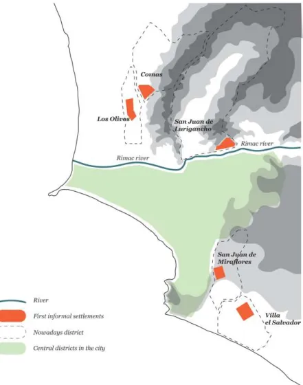
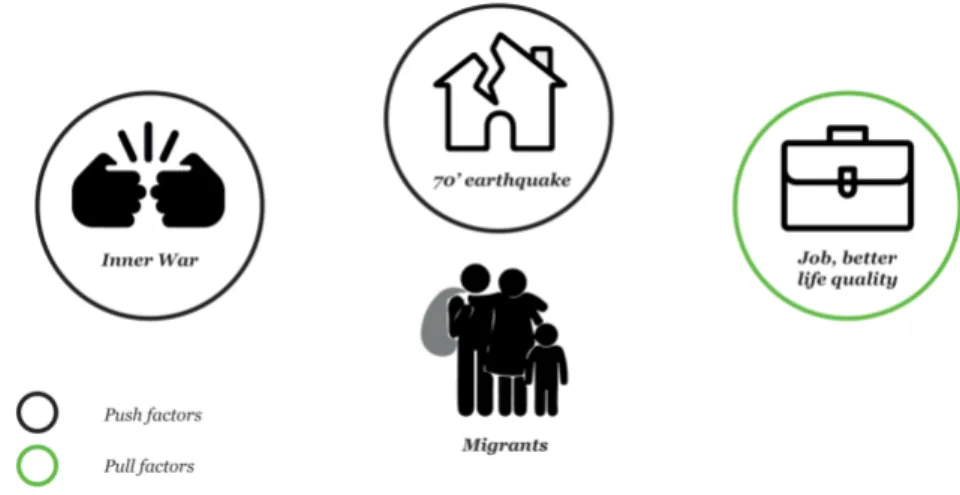
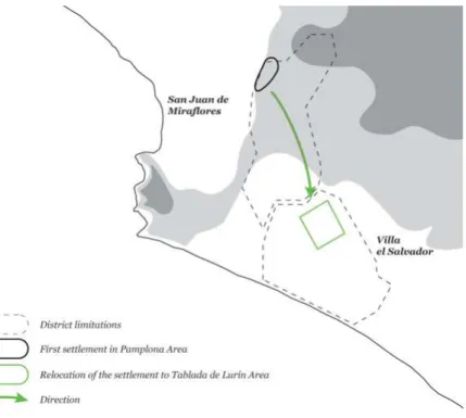
In the 70’s, a big earthquake occur in the country, forcing the people to move from their cities to a more stable place. Apart from that the inner war that started to take more relevance in the highlands, a strong search for new opportunities and a better life start moving a huge number of people to the capital (Noel, 2009; see Figure 10), this determined two types of migration movements, by push and pull factors, at present the most important factor that remains in the city is the pull factor due to the globalization of the city and the need for labor (Stanojoska et al, 2012). They did not find a place to settle in the city so they settled on the slopes of some hills at the back of the city, a place that is now Pamplona Alta (See Figure 11). This terrain to date is an area of risk, of loose terrain prone to collapse from rain and tremors. This led the government to enact Law 13517, which conceptualized the invasions as slums or marginal neighbourhoods (Ramirez, 2006). And it also gave an alternative to eviction, they had to relocate to the outskirts of the city and without any infrastructure.
Somehow, this helped migrants in the beginning, not to move to risk-prone areas, but it stigmatized the popular neighbourhoods, which may be one of the initial reasons for the polarization of the city.
Figure 10. Push and Pull factors that motivated the migrants. Source: author based on Ramirez, 2003.
The community of Pamplona had to relocate to a deserted area south of the city.
Forming the young town of Villa el Salvador (see Picture 9). As the initial community felt isolated from the city and unable to be included in it (Vulliamy, 2016), a social cohesion was generated which strengthened the participatory processes that directed their neighbourhood progress (conceptualized as the willingness of the community in order to survive and prosper; Stanley, 2003). From the beginning the district had a complete vision of the city, defining spaces for roads, small businesses and commercial activities (Abbot et al, 2016). The early district was planned through residential groups comprising 16 blocks around a free zone for communal use, thus ensuring that the future district would be occupied in a planned manner (Ramirez, 2003). This is an interesting factor that differentiates it from the other young towns in the city, the migrants found a land previously defined by the state, generating a positive synergy of state and community. The country’s Ministry of Housing had already planned the expansion of the city towards the south since before the previous settlement in Pamplona, making it possible to carry out an urban habilitation project for the capacity of 250,000 people (Sinamos, 1974).
Figure 11. First invasion and resettling of the community. Source: author based on Ramirez, 2003.
However, the community, considering the upcoming shortage, left spaces to facilitate the supply of water to the young city. A development plan was defined through agreements with the government and the local community. All these internal improvements were taken as examples for various informal settlements in the city.
Villa El Salvador owes its progress to its own local actors. When the armed conflict arrived in the city, the district was one of the first places to be taken over by terrorists.
Other actors defended the district which could never be appropriated as a rebel base due to its erroneous ideology which did not agree with the poor class of Lima.
To facilitate the attention of these preventions the communal organization CUAVES, Urban Self-managed Community of Villa El Salvador was formed in 1973, which generated plans that integrated the community and placed them as the main actors in its growth and organization (Montoya, 2010). This methodology for the Peruvian political conjuncture at that time, since it did not look for to be in any extremist side of the
Picture 9. Arrival to the assigned land in Tablada de Lurín. Source: Photo from Amigos de Villa, side website from the Documentation Centre of Villa el Salvador.
political spectrum, but rather raised an own identity by means of the active citizen participation that was rejected at its moments (Marañon, 2016), something that is a common denominator in the national policy in front of the new urban ideas.
The following are the 4 pillars mentioned above that erected the said organization, gathered from the CUAVES statutes, (published in ESTATUTOS CUAVES, 1973 by a general assembly).
- To seek human and social development according to the solidarity values of freedom and justice,
- To generate a productive base and economic support, by means of communal and social property enterprises of production and services,
- Improve their mechanisms of local self-government as a revolutionary expression of a social democracy of full participation,
- To contribute permanently, to achieve and consolidate a socialist, humanist and solidarity-based society.
In the ‘80s, the self-managed community became distracted. It began with this the construction of infrastructure necessary to be able to position itself as a district where Professor Michel Azcueta was elected as the first mayor (see Annex 02). This mayor led a good relationship between the institution and the community, signing an agreement between them that was inscribed with the slogan ‘Ley comunal es ley municipal’ (Communal law is municipal law; Municipalidad de Villa el Salvador, 2008). Construction began on basic requirements such as schools and pharmacies, having 3 main axes: health, education and food supply. It is important to point out that at the end of 1983 FEPOMUVES was created in sector 3. This is the popular women’s federation of Villa El Salvador, and it was the municipality and CUAVES that were the main promoters of its social development and district growth. After its development and position as an example district in the city, it was awarded the Prince of Asturias Award in 1987, where it is recognized as a messenger city of peace by the United Nations (Municipalidad de Villa el Salvador, 2008).
Figure 12. From the first settlement to the current status of the district. Source: author based different sources and Obsevatorio Urbano Desco, 2005.
The ‘90s began as a sad time in the district and much of the country. The internal war had come to Lima and shook the stability of the district (Kruijt et al, 2013). All these acts of social and political violence generated in turn a response of integration and cohesion in the district. In 1992, the district signed a twinning agreement with the Miraflores district (which is part of Lima Centre) as the districts most affected by the internal war.
Another symptom that the inner war was the lack of work in the city and alongside
several parts in the country (Limanchi, 2017). Lima had a lot of people as residents but no production, making the economy unstable and weak. Moreover, this economy cannot be sustainable under just an extractive perspective. Apart from that, the internal expenses that caused the internal conflict, deteriorated the productive level of the capital. This scenario prompted the government to establish an industrial park that would serve the southern cone and the city, determined to be large and medium scale. This idea were originated since the 70’, the project started on a neighbourhood scale to now be a sector known throughout the city for its furniture manufacturing (Alvarado et al, 2019). At the same time this industrial park diversified, now has metal mechanical companies, some shopping centres and has become an area of strong economic development attracting investment (Abbot et al, 2016; see Picture 10). While the other side of the district still lacks infrastructure and development, becoming mostly residential with low quality housing and a local economy.
Picture 10. ‘Boulevard del Cuero’ (Leather Boulevard), located on the avenue that leads to the Villa el Salvador metro station in the industrial park.. Source: Photo from Stereovilla.pe website.