That the Regional Planning Board receive for its information the report dated August 24, 2020, entitled "Manager's Report". That the Regional Planning Board receive for its information the report dated May 25, 2020, entitled "Manager's Report".
Metro Vancouver Planning Committee LATE DELEGATION REQUEST
TRANSFORMATIONAL ACTIONS
Require all new large buildings to be carbon neutral, resilient to local climate change impacts, and located in Urban Centres or in appropriate locations along the Frequent
Staff recommends that the Regional Planning Committee endorse the 2020 Declaration on Resilience in Metro Vancouver Communities and forward it to the COVID-19 Response Task Force for consideration and endorsement. Staff recommends Alternative 1 that the Regional Planning Board endorse the 2020 Declaration on Resilience in Metro Vancouver Communities and forward it to the COVID-19 Response Task Force for consideration.
2020 Declaration for Resilience in Metro Vancouver Communities
Require all new buildings that are government-owned (federal, provincial and municipal) or built with public funds to be carbon neutral over their lifetime. Require all new large commercial, institutional and residential buildings to be carbon neutral, resilient to the local impacts of climate change and located in city centers or in suitable locations along the frequent transit network.
Updating the 2020 Declaration for Resilience in Canadian Cities to Reflect Metro Vancouver Context / Priorities
- Include a Frequent Transit Corridor Network map to simplify the use of the FTDA tool. This map would help make it simpler for member jurisdictions to identify new FTDAs in their
- Strengthen Compact and Complete Development Policies to Support Climate Change Mitigation and Adaptation and other Regional Priorities. This would better reflect new and
- Clarifying the Frequent Transit Development Area tool: Adding a Frequent Transit Corridor Network map into Metro 2050 will help member jurisdictions in identifying preferred
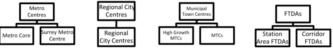
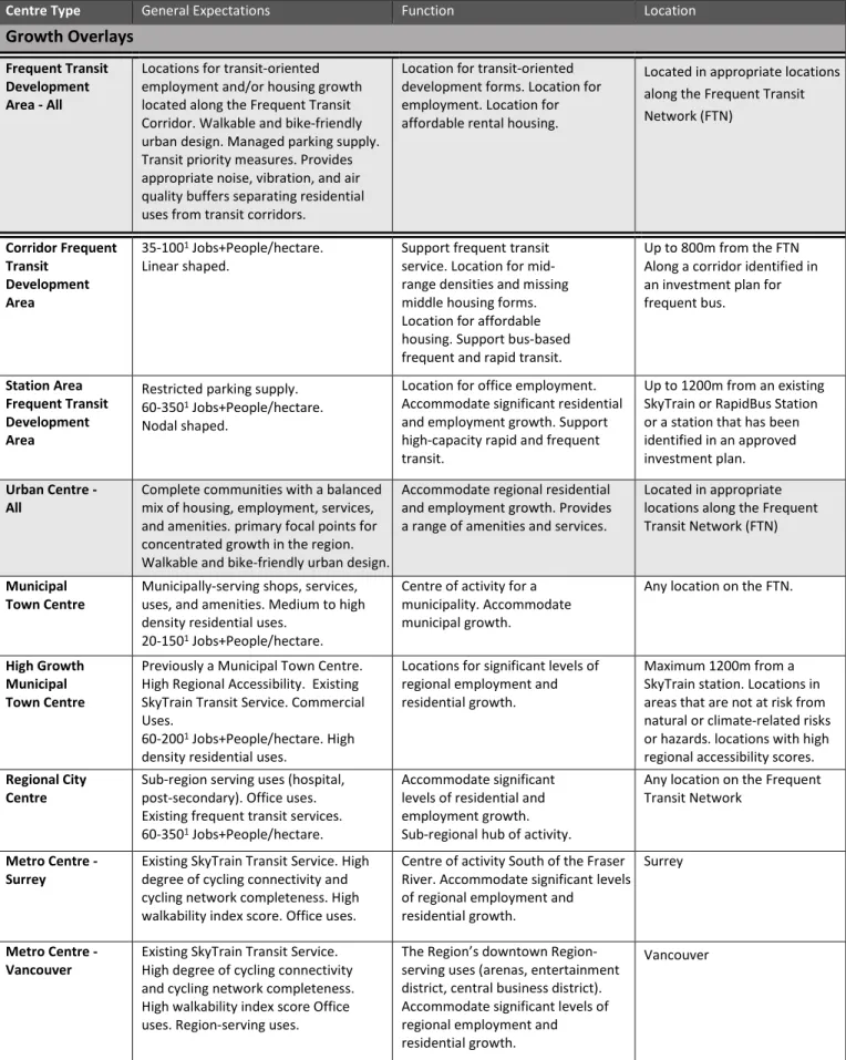
- Additional differentiation: By dividing Municipal Town Centres and Frequent Transit Development Areas into subtypes, the degree of variety within the centre types will be
- Specifying growth expectations: By refining the Urban Centre and FTDA growth targets to include sub-regional or municipal-level growth targets, the growth expectations for each
- Climate action: With the addition of regional accessibility measures, the updated growth framework will better support focusing growth in areas with a high degree of transit
- GHG modelling: Regional Planning is partnering with Metro Vancouver’s Air Quality and Climate Change Division to model potential policy changes with a view to considering how
- Consider social equity and resiliency: The second phase of the Social Equity in Regional Growth Management study is underway, and will develop a social equity framework that can
Metro 2040 Urban Center and FTDA Policy Review Recommendations Regional Planning Committee Regular Meeting Date: September 11, 2020 Page 5 of 7 Metro 2040 Urban Center and FTDA Policy Review Recommendations Regional Planning Committee Regular Meeting Date: September 11, 2020 Page 7 out of 7.
INTRODUCTION
KEY CONCEPTS
Transit Oriented Development (TOD): an urban development best practice that concentrates residential, commercial, and recreational development within walking distance of public transportation with the goal of maximizing the number of riders with access to high-quality transportation. Transit-oriented communities: Transit-oriented communities in Metro Vancouver are places that make walking, cycling and transit use convenient and desirable, and that maximize the efficiency of existing transit services by focusing development around transit stations, stops and interchanges. TransLink encourages the development of transit-oriented communities close to transit through the Transit-Oriented Communities Design Guidelines (Reference 13).
Activity density: Activity density is a measure of the average number of residents plus the number of workplaces per person. hectares within a given geography (Jobs+People/hectare). Activity Density is used by many regional and transportation planning agencies, including TransLink to support land use and transportation planning for urban centers (Reference 14).
POLICY REVIEW BACKGROUND AND SCOPE
ENGAGEMENT AND RESEARCH KEY LEARNINGS
Multiple issues have been identified with the FTDA tool
Meanwhile, there is a strong desire for the identification of FTDAs to be paired with transportation funding programs and more certainty around increased transit service. However, the region should avoid identifying additional urban centers as far as possible in order to avoid degrading the existing urban centres. Stakeholders want clearer, quantifiable criteria and more refined targets to help set expectations for urban centers and FTDAs and to support the integration of growth and transport planning.
There is a need for additional Urban Center and FTDA planning guidance relating to urban design and community amenity provision. This is a reflection of the fact that the region is maturing and becoming more complex. 11. Regional service providers, including TransLink and Metro Vancouver utilities, need better and long-term growth planning information from member jurisdictions and from First Nations to support long-term capital planning.
RECOMMENDATIONS
Monitor transit-oriented growth: The FTCN will be used to monitor transit-oriented housing and employment growth along the FTN. Following each census, a customized data assignment will be submitted to Statistics Canada and population and employment growth in this region will be reported through Metro Vancouver commissions and other reporting structures. Growth will be reported as the share of total housing and employment growth in the region that occurs within the FTCN.
Growth monitoring in this geography will be done in addition to growth monitoring related to Urban Center growth targets. Recurring updates to FTCN geography are consistent with the iterative updates to city center boundaries and FTDAs that member jurisdictions regularly adjust. By defining a clear baseline geography, the FTCN makes it easier to understand the range of locations where FTDA could potentially be identified.
Recommendation #2: Update the Urban Centre and FTDA Typology
Only existing urban centers or development areas with frequent public transport can be considered for reclassification to a different center type. New urban centers (where no growth overlay previously existed) would continue to require a Type 2 amendment, while new Frequent Transit Development Areas (FTDAs) would remain a Type 3 amendment (both status quo in Metro 2040). Adjusting employment and housing growth targets for urban centers and areas along the FTN to support regional and municipal targets.
This could include lowering employment growth targets for urban centers to reflect market trends. Continue to develop walking and cycling infrastructure programs that are linked to the growth framework and that prioritize improvements in urban centers and FTDAs. Metro Vancouver will also be responsible for updating implementation guidelines to support member states' planning efforts around urban centers and FTDAs.
BENEFITS AND LIMITATIONS OF RECOMMENDED CHANGES
Clarifying the Frequent Transit Development Area (FTDA) tool: Integrating the Frequent Transit Corridor Network geography into Metro 2050 will help signal to member jurisdictions
Additional differentiation: By dividing Municipal Town Centres and Frequent Transit Development Areas (FTDAs) into subtypes the degree of variety within a centre type will be
Specifying growth expectations: By refining the growth targets to include sub-regional or municipal-level growth targets for Frequent Transit Development Areas and Urban Centres
Additional integration with regional transportation planning: Using the Jobs+People / hectare “Activity Density” metric as a defining component of the growth framework helps to
Climate action: With the addition of regional accessibility measures the updated growth framework will better support focusing growth in areas with a high degree of transit
NEXT STEPS
Development of Regional Accessibility measures: Regional Accessibility will be an important new component guiding the update to the centre typology, updated growth targets, and the
GHG Modelling: Regional Planning is partnering with the Metro Vancouver’s Air Quality and Climate Change Division to model potential policies alternatives to reduce GHG emissions in
Development of Climate Risk map(s): Spatial analysis of areas with higher degrees of climate change and natural hazard risk are required to guide the update to the centre typology,
Application of a Social Equity Lens: The second phase of the Social Equity in Regional Growth Management study will develop a ‘social equity lens’ that can be used to evaluate and ensure
APPENDIX A
TransLink workshop and other comments: On April 8, 2019, staff organized a workshop for TransLink staff on the topic of Urban Centers and FTDAs. Participants questioned the need for plot-based maps of urban municipal centers and the need to identify freight movement routes to, from and within Urban Centers and FTDAs in RCS. Utility planners would like information on growth for areas within and outside Urban Centers and FTDAs.
TransLink staff recommended that the new Town Center and FTDA criteria be aligned with the TransLink Service Guidelines and the “6Ds of Transit-Oriented Communities” wherever possible. Metro Vancouver Utilities Feedback: Utilities staff suggested that it would be beneficial for Metro Vancouver to report growth rates in various urban centers and FTDAs. Metro 2040 Climate and Natural Hazards Policy Review Feedback: The Climate and Natural Hazards Policy Review Team reviewed and provided comments on the Urban Center Policy Guidelines and FTDA to ensure they support the region's climate change adaptation and mitigation goals.
APPENDIX B
Evaluation and Research
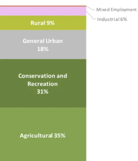
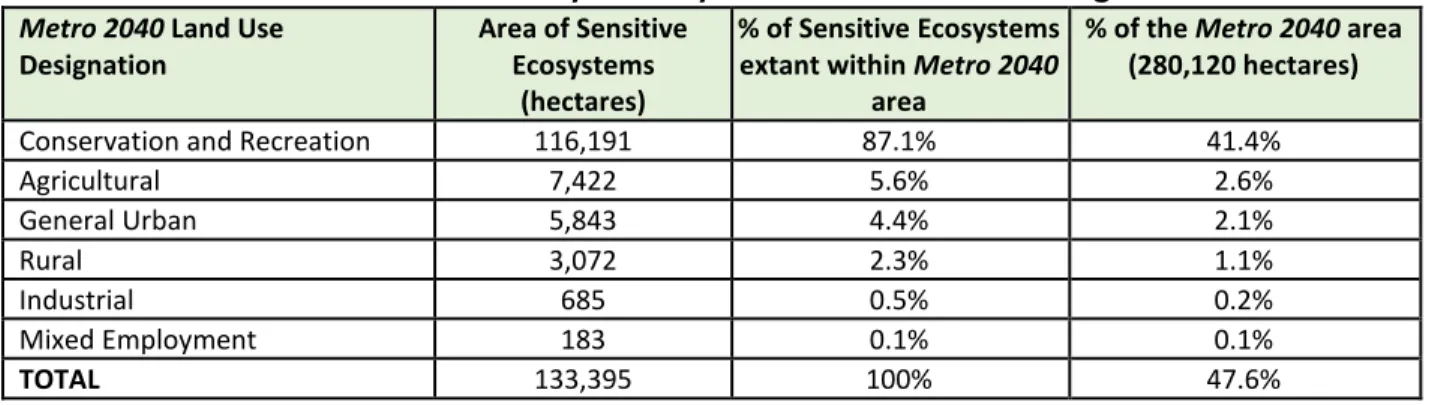
To inform policy directions, Regional Planning: reviewed past regional growth strategies; conducted a scan of members' regional context statements and official community plans; compared lands designated in the region for Conservation and Recreation (Con/Rec) with the Sensitive Ecosystem Inventory;. An analysis of significant ecosystem losses from 2009-2014 was presented to the Regional Planning Committee at its meeting on 13 September 2019.
Environmental Land Use Policy Forum
Policy Ideas and Options
- Clarify the definition of uses and activities for the regional Conservation and Recreation (Con/Rec) Land Use Designation
- Include a new regional vision by setting aspirational regional targets for protecting, enhancing and restoring ecosystems
- Add policy actions that support a regional green infrastructure network. Several member jurisdictions have adopted green
- Integrate the Sensitive Ecosystem Inventory (SEI) and add supportive policy actions. The SEI was not available in 2011
- Add policy actions that support equitable access and exposure to green space in urban areas. Local health authorities and
Metro 2040 lacks content on some of the current environmental land use priorities in member jurisdictions. As part of the Metro 2050 update, Regional Planning is undertaking 11 policy reviews to support revisions within the current Regional Growth Strategy. That the MVRD Board approves the recommendations of the Metro 2040 Environment Policy Review as presented in the report dated August 21, 2020, entitled "Metro 2040 Environment Policy Review Recommendations" as the basis for Metro 2050 environment-related policies.
That the Regional Planning Committee receive for its information the report dated August 21, 2020 entitled "Recommendations for the Metro 2040 Environmental Policy Review". The Metro 2040 Land Use Environmental Policy Forum and the consultant study completed as part of the policy review cost approximately $4,000 and $10,000 respectively. Policy language for Metro 2050 will be prepared in late 2020 based on other recommendations from the Metro 2040 policy review, including work being done on social equity, climate change and resilience.
ATTACHMENT
20 Recommendation No. 6: Add new policy actions that support equitable exposure and access to green space in urban areas.
EXECUTIVE SUMMARY
Therefore, staff recommends adding policy measures to protect sensitive ecosystems inside and outside conservation and recreation areas, as well as policy measures for Metro Vancouver to assist member jurisdictions with data, information to help prioritize and create best practices. The inclusion of SEI-related policy measures in Metro 2050 will strengthen the scientific basis for ecosystem protection and restoration. Add policy measures that support equitable access and exposure to green spaces in urban areas.
During the policy review consultation process, several member jurisdictions expressed the need for a guidance document for the implementation of Goal 3, similar to those for other Metro 2040 policy areas, to support the understanding and implementation of environmental policy measures in the regional growth strategy. Metro 2040 includes several policy actions for Metro Vancouver, member jurisdictions and other levels of government to protect important ecosystems, but these policy actions were developed without a consistent, science-based ecosystem inventory. This report provides an overview of the process Metro Vancouver staff took to review environmental policy measures in Metro 2040 and describes the recommended revisions under consideration for Metro 2050.
BACKGROUND, PROCESS AND SCOPE
Policy forum (Summer 2019)
On June 6, 2019, Regional Planning hosted a policy forum with key stakeholders (including RPAC members, RPAC-Environment subcommittee members, provincial staff, academics and other Metro Vancouver staff) to solicit feedback on existing policy gaps and challenges in implementation. The results of this forum were shared with the RPAC in July 2019 and the Regional Planning Committee in September 2019.
Policy options exploration (Fall/Winter 2019 – Summer 2020)
WHAT WE DID AND WHAT WE LEARNED
- Locations of sensitive ecosystems
- Recent sensitive ecosystem losses
- Other uses on lands with the regional Conservation and Recreation designation
- Improve alignment of the Conservation and Recreation Regional Land Use Designation with its intended purpose
- Develop a regional vision and aspirational targets for ecosystem protection, enhancement and restoration
- Explore a regional green infrastructure network
- Integrate the Sensitive Ecosystem Inventory
- Support equitable access and proximity to green space in urban areas to maximize health benefits
It was not previously available to help determine which lands could be included in a regional conservation and recreation designation, nor is it referenced in the Metro 2040 policy measures. Most, but not all, regional context statements include maps that show land use designations for Metro 2040 Conservation and Recreation and applicable policy measures. Discuss with member jurisdictions whether policy measures on ecosystem connectivity should also be included in Metro 2050.
Subsequent step taken: As part of Phase 2 of this Policy Review, Regional Planning discussed with stakeholders whether urban green space policy actions should be included in Metro 2050. Including the Sensitive Ecosystem Inventory and related policy actions in Metro 2040 and Official Community Plans. Recommendation #3: Add policy actions that support a local green infrastructure network Several member jurisdictions have adopted green infrastructure/ecological network plans to improve ecosystem connectivity.
BENEFITS AND LIMITATIONS OF RECOMMENDATIONS
FURTHER WORK
That the Regional Planning Commission receive for information the August 20, 2020 report entitled “Engaging and Recognizing First Nations in Metro 2050.”. First Nations are identified as one of four core target groups in the Metro 2050 Engagement Plan (Reference 1). First Nations have been identified as one of four target groups in the Metro 2050 Engagement Plan (Reference 2).
Engage and Recognize First Nations in Metro 2050 Regional Planning Committee Regular Meeting Date: September 11, 2020 Page 3 of 5 First Nations in Metro Vancouver may participate in other opportunities to engage with Metro 2050 that are open to a wider range of audience groups. Engage and Recognize First Nations in the Metro 2050 Regional Planning Committee Regular Meeting Date: September 11, 2020 Page 5 of 5.
KPU ~